Stuff I wrote in 2018

I was busy on a keyboard this year, even though there were long gaps between posts on this site. In case you missed them, here are the posts that I wrote for explore.org in 2018. They are listed in the order they were posted. My personal favorites include “How does a bear family breakup,” “How many salmon will a bear eat,” “Bearcam live chat surprise,” and “Living with Bears in Churchill.”

  • Brooks River Bear Mating Season: In June, food isn’t the only thing on a bear’s mind.
  • 2018 Bearcam Stories: 503: Emancipated from his adopted mom in the spring of 2016, bear 503, also known as Cubadult, has quickly grown into an energetic and often playful young adult.
  • Early June at Brooks Falls:  Standing at the falls from early to mid June is an exercise in patience and an opportunity to reflect on the changes soon to come.
  • 2018 Bearcam Stories: The Elders of Brooks River: Their longevity of Brooks River’s oldest bears demonstrates a level of individual success few bears achieve.
  • The Mouth of Brooks River: The lower river cams provide expansive views, colorful sunrises and sunsets, as well as the opportunity to see many yearly and seasonal changes.
  • What to Look for 2018: The Bear Hierarchy: Watching the ebb and flow of the hierarchy allows us to at least partly understand the conflict and challenges faced by bears.
  • Bear 856: On Top Again: Bear 856 appears to be big enough and healthy enough to show the river’s other adult male bears he’s ready to compete once again.
  • Death of a Bear Cub at Brooks River: As the smallest and most vulnerable of all bears, first year cubs (also called spring cubs or cubs-of-the-year) face significant risks and challenges, not the least of which are larger bears.
  • Dumpling Mountain Hike: Rising over 2000 feet above Brooks River, Dumpling Mountain offers anyone a quick escape from the hustle and bustle of Brooks Camp. Each time I hike on it, I get an opportunity to see the land in a new way.
  • Four Cubs for 402 Again: No matter this family’s fate, we can marvel at 402’s determination to follow her maternal instincts in an attempt raise another generation of Brooks River’s bears.
  • How Does a Bear Family Breakup? Until somewhat recently, I stated that 402 had “abandoned” her yearling (now known as 503). While this might be true in a sense, I no longer think that this is an accurate way of describing the event. After reading more about the emancipation process, I’ve come to believe 402 didn’t abandon her yearling in 2014. She emancipated him.
  • How Many Salmon will a Bear Eat? We often observe bears partake in marathon fishing sessions at Brooks Falls, so how much can they eat in a day or season? Quite a lot.
  • Salmon on the Underwater Bearcam: The calmer, deeper water near the outlet of Brooks River provides salmon with a temporary refuge that is relatively safe and costs them little energy.
  • 451 and Her Yearlings: 451 is currently raising her second litter, and it’s easy to see that the family is skinner than many of the other bears on the bearcams.
  • Bearcam Line of Sight: Where are the bearcams and where, specifically, do they look?
  • Brooks Falls Trail: Simply walking to Brooks Falls can be an exciting and memorable experience and allows great opportunities to explore a changing habitat.
  • Mid Summer Change at Brooks River: Are fewer bears at Brooks River a sign of change?
  • An Exceptional August: Regarding bear activity at Brooks River, August 2018 has been exceptional.
  • Fishing By Snorkeling: Efficient and effective, snorkeling is one of the best strategies to scavenge fish.
  • Can a Bear be Too Fat? When you see bears whose stomachs appear to drag on the ground, one wonders if a bear can grow too fat for its own good.
  • Bearcam Live Chat Surprise: “This being a live broadcast it’s entirely possible…a bear could walk through the screen at any time. So if we have to exit or end the broadcast abruptly that’s probably why.”
  • Fat Bear Week Quarterfinal Preview: The competition just keeps getting bigger.
  • Mike Fitz’s Favorite Bearcam Moments of 2018: Here are a few of my favorite bear cam moments for 2018.
  • Evidence of Rapid Change in Katmai: the Ukak and Savonoski Rivers spill across a broad, 1.5-mile wide delta. In a landscape often defined by change, this is one of the most dynamic places in Katmai National Park.
  • 2018’s Top Ten Bearcam Moments: the people have spoken! Bearcam viewers have chosen the top ten bearcam moments of 2018. Each moment is unique and significant for a different reason.
  • Living with Bears in Churchill: The confluence of bears and people in this remote community has created a special set of challenges, which can only be met through the town’s willingness to tolerate the largest four-legged predator on Earth.

Vote on Climate

In my last post, I explored the origins of an alpine lake in North Cascades. The news cycle was especially terrible the day I wrote it, so I decided to leave out details about the causes and consequences of glacial retreat in North Cascades. But honestly, the causes and consequences are too great to ignore. It is no small irony that my insight and enjoyment into the formation of an alpine lake was inadvertently provided by people through human-caused climate change.

All glaciers in North Cascades are retreating and they’ve collectively lost over 50% of their mass during the last 100 years. This is directly due to a warming climate, a product of burning fossil fuels like coal and oil.

before and after photos of glacier.

Banded Glacier in 1960 (left) and 2016 (right) in North Cascades National Park.

Unless you’ve been living under one of those glaciers for the past century, you might’ve heard there’s an election next week and voting has begun in many states. While casting our votes, we have an opportunity to elect representatives who will work to mitigate climate change. But, we shouldn’t vote to combat climate change just because glaciers are receding in North Cascades National Park.

We should act on climate, because glacial melt water moderates summertime drought. Millions of people depend on glaciers for drinking water.

We should act on climate to lessen the risk from extreme weather events like drought, hurricanes, floods, and heat waves.

We should act on climate to ensure supplies of fresh water are not overly taxed by humanity’s increasing demands. Who wants reliable access to clean fresh water? All of us.

We should act on climate to help reduce the spread of invasive species, many of which are finding easier footholds where ecosystems are already stressed and fragmented.

We should act on climate to prevent the loss of arctic sea ice, a habitat that helps cool the planet by reflecting sunlight into space, forms the basis of a complex polar food web, and is one necessary for the survival of polar bears.

We should act on climate so coastlines aren’t flooded by sea level rise.

We should act on climate to mitigate ocean acidification, which can impact marine food chains. A lot of us eat seafood and even if we don’t, we like animals that eat seafood (whales, bears, etc.). What would Katmai National Park, my favorite place, be without abundant salmon? An impoverished place, that’s what.

I could go on, but I think you get the point.

We have a moral responsibility to stave off the worst climate change impacts, because this is a human-caused issue. Collectively we can do it, but we have to take the threat seriously. We, as a nation, didn’t vote to combat climate change during the 2016 election. Thankfully, we have another chance now, but time is running out to slow and eventually halt what is one of the most pressing issues facing humanity. That’s why I’m voting for initiatives to mitigate climate change and only for candidates who take climate change seriously.

photo of Washington State ballot showing yes selected for Initiative 1631

In Washington, Initiative 1631 would authorize the first carbon tax in the U.S. This is my ballot.

I’ve been fortunate enough in my life to explore active glacial environments in many parts of North America. In Katmai, I’ve walked on pumice-covered glaciers to reach volcanic calderas, numbed my feet in icy glacial runoff, and eaten freshly calved ice (if you’re wondering, it was clean tasting but a little gritty). In the North Cascades I explored the margins of the region’s still active ice. To find an advancing glacier in modern times, however, is rare. Melting glaciers are one of our most conspicuous symbols of global warming.

Glaciers have come and gone in the past, of course. I grew up in a region of Pennsylvania where Ice Age glaciers terminated their last advance, leaving behind eskers and sand quarries. I lived near Lake Chelan, a remarkable inland fjord carved by glaciers. Katmai was also completely overrun by ice. Modern glacial retreat is different though, because we’re the primary cause. Climate change isn’t a hoax or some deep-state conspiracy. It’s real, it’s here, and humans are causing it. There is no scientifically plausible alternative theory that explains the changes to Earth’s climate observed since the Industrial Revolution.

I still find beauty in the ice, but each time I see a glacier I also am reminded of one of Aldo Leopold’s many maxims,

“One of the penalties of an ecological education is that one lives alone in a world of wounds. An ecologist must either harden his shell and make believe that the consequences of science are none of his business, or he must be the doctor who sees the marks of death in a community that believes itself well and does not want to be told otherwise.”

The community is not well, because we’ve wounded it. Let’s step up and act. When you vote, only vote for those who take climate change seriously and, more importantly, will actively work to reduce its impact. The status quo got us here, but the status quo is no longer good enough.

Pebble Mine Scoping Comments

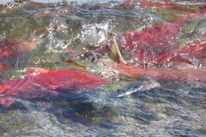
Recently, I wrote about an impending threat to Bristol Bay’s salmon: Pebble Mine. The mine, if developed, will have significant effects across some the richest salmon and brown bear habitat left on Earth.

Salmon remain the ecological and cultural heartbeat of Bristol Bay. This mine will create billions of tons of semi-fluid toxic waste, which must be treated and prevented from entering the watershed indefinitely. Impacts from development are never completely restricted to the development’s footprint either. Roads fragment habitat and vehicle traffic displaces wildlife.

When I was born, Pacific and Atlantic salmon fisheries in the Lower 48 states were already significantly degraded. Nearly 40 years later, many salmon stocks in New England, California, Oregon, and Washington remain threatened or endangered. Only a small fraction of fish return to these areas compared to historic levels. I’m not about to let this story repeat itself in Alaska, nor should you. If the mine is developed, future generations will inherit its legacy, and I predict they won’t look upon us fondly for repeating the same mistakes that killed salmon runs in the past.

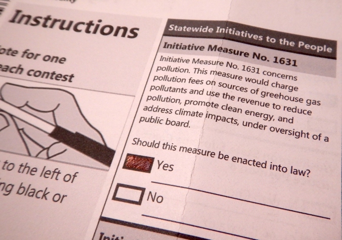
Please comment during the scoping period on the Army Corps of Engineers’ Pebble Mine Environmental Impact Statement (EIS) and send those comments to your congressional representatives as well. Below you’ll find my scoping comments for the proposed mine. Feel free to copy and personalize them as you see fit. State your concerns now, so when the Army Corps of Engineers writes the EIS it will fully evaluate the mine’s impacts. Don’t let Bristol Bay’s salmon disappear because of our lust for copper and money.

The Corps is accepting comments through June 29, 2018.

salmon jumping at waterfall

Comment to the U.S. Army Corps of Engineers (submitted May 23, 2018):

The proposed Pebble Mine and its associated infrastructure poses a substantial threat to salmon and wildlife across the Bristol Bay region. Pebble Mine will straddle the watershed divide between two of Bristol Bay’s most important salmon spawning and rearing areas. I remain very concerned with the mine’s potential to negatively impact the area’s fisheries and wildlife through its wastewater, tailings, and infrastructure.

The EIS must answer one question: can Pebble Mine be developed without significantly degrading water quality and fisheries? The Corps’ has authority to deny permits under section 404 of the Clean Water Act if a proposed action will significantly degrade water quality and fisheries. This EIS should evaluate and quantify, not just identify, the mine’s potential to significantly degrade water quality and fisheries over short and long-term timespans. The EIS can begin this evaluation by appropriately defining its purpose.

A recent environmental impact statement from the Army Corps of Engineers, the Donlin Mine EIS, merely stated the purpose of the mine and the Corps’ authority to permit it (Donlin Mine Final Environmental Impact Statement – Chapter 1, pg. 1-4, 1-6). The purpose and need of the Pebble Mine EIS should be not be to simply define the project’s purpose (to mine ore) and define the Corps’ regulatory authority. It should be, as I propose, to:

  • Identify the short-term and long-term ecological effects of the proposed Pebble Mine,
  • Evaluate the mine’s and its infrastructure’s impacts on wildlife, including fish, in order to
  • Determine whether the mine’s safeguard can prevent all degradation to water quality, salmon habitat, and wildlife habitat indefinitely.

Even at very low concentrations, dissolved copper is particularly toxic to salmon, interfering with their ability to navigate and avoid predators. Its effects can manifest over minutes or hours and persist for weeks (Hecht 2007). Can the mine’s wastewater treatment plan adequately remove dissolved copper and prevent it from entering the watershed?

The mine’s tailings also pose a great risk to fish. Any accidental discharge from the pyritic tailings ponds will significantly degrade salmon habitat. Open pit mines, even within the United States, have a poor record containing their toxic tailings. Most tailings dam failures occur at operating mines and 39 percent of such failures worldwide occur in the United States, significantly more than in any other country (Rico 2008). Earthquakes and flooding hazards increase the risk of a tailings pond dam failure in the Bristol Bay region, and tailings ponds cannot be drained in the event of flooding or dam failure due to their toxic contents. The probability of a M8+ earthquake, for example, is low from year to year but remains real at any given time. Therefore, the EIS must also evaluate whether the tailings ponds can be engineered to withstand the greatest potential earthquakes and floods expected over the next several thousand years.

After the mine’s 20-year active phase, the mining company proposes to store toxic pyritic tailings indefinitely under water in the former open pit. This seems to create the potential for acid mine drainage to leach into the watershed over hundreds or thousands of years. What geologic studies suggest this is a feasible long-term plan to store the tailings? Even if subaqueous storage in the former open pit prevents the tailings from oxidizing, what safeguards will prevent dissolved copper and other toxic metals from entering groundwater to eventually oxidize and acidify as it nears the surface in a different part of the watershed?

The mine’s supporting infrastructure also creates risks for salmon and wildlife. Although salmon can navigate and migrate through streams with high sediment loads, they do not spawn in these habitats. Erosion of sediments into streams can irritate the gills of fish, smother eggs, alter feeding habitat for salmon fry, and bury spawning habitat. The effects of road construction and vehicle traffic (estimated by the mining partnership to be 35 round-trip truck trips per day) on wetlands and fisheries should also be evaluated.

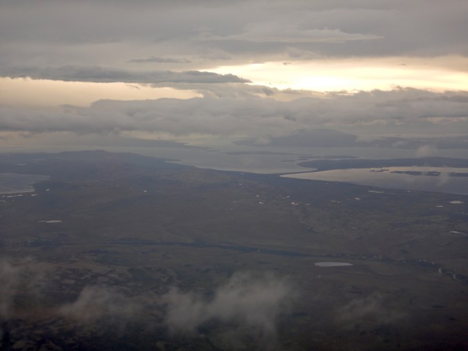
The road servicing the proposed Amakdedori Port and the port itself will fragment what is now an unspoiled region of coastline on Cook Inlet. McNeil River State Game Sanctuary is one of the most important brown bear refuges on Earth, home to the largest annual congregation of bears yet observed. The road and port have the potential to displace bears moving to and from the McNeil River and Katmai National Preserve areas. Frequent work and dredging at the port area will also displace wildlife in an area that now experiences very little human activity. Other alternatives to transport ore should be evaluated.

Finally, the EIS needs to address more than the 20-year operational phase, because the mine’s waste legacy will threaten salmon for thousands of years. Tailings stored in the former open pit won’t become benign in the near future and wastewater must be treated indefinitely. Also, the possibility of an expanded mine operating over a long time frame increases the threat to salmon, other wildlife, and clean water.

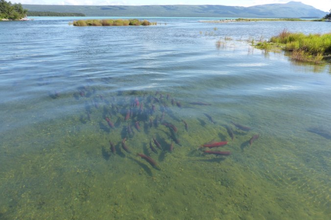
Combined, the Nushagak and Kvichak rivers support about 40% of Bristol Bay’s sockeye salmon. In 2017 alone, over 56 million sockeye salmon returned to Bristol Bay and over 19 million returning to Nushagak River, the largest in the river’s history. Salmon fishing in Bristol Bay is a billion dollar industry. While commercial fisheries generate the bulk of the salmon’s economic value, the area’s tourism is almost entirely based on salmon as well. Bristol Bay is home to dozens of premier sport fishing destinations, which harbor abundant populations of rainbow trout, Dolly Varden, arctic char, northern pike, lake trout, and grayling. The Bristol Bay area also hosts some of the densest populations of brown bears ever measured. Salmon are the most important food source for these animals, and the vast majority of people who visit Katmai National Park come to watch brown bears (Strawn 2015). After spawning, dead salmon fertilize the ecosystem with nutrients derived from the ocean, boosting the productivity of otherwise nutrient-poor area.

Considering the overwhelming economic and ecological value of salmon to the Bristol Bay region, Pebble Mine could displace thousands of workers and tourists if its safeguards fail to protect salmon. Without the energy and nutrients provided by consistently large runs of anadromous salmon, Bristol Bay’s freshwater and terrestrial ecosystems will quickly transition from one of richness to poverty. In many ways, this cycle is a positive feedback loop. The productivity of the area is reliant on large runs of salmon.

We’ve seen, repeatedly, salmon populations in the Pacific Northwest and New England decimated by habitat loss and pollution. Now we’re on the brink of repeating the same mistake in Bristol Bay. Pebble Mine should not be developed. It’s in the greatest interest of Bristol Bay’s fishing industry and culture, watersheds, salmon, and wildlife for the Corps’ EIS to fully evaluate the mine’s near and long-term effects. A failure to contain the mine’s toxic tailings and wastewater would directly impact two of Earth’s most productive salmon producing watersheds. The EIS must address potential groundwater exchange in the abandoned open pit, and whether the mining company can eliminate the risk of acid mine drainage. It must address whether the embankments for tailings ponds can withstand high magnitude earthquakes. It must address whether it’s even appropriate to build a mine whose wastewater will need to be treated indefinitely. It also must critically evaluate the mine’s supporting infrastructure, as it will potentially disrupt the world’s largest seasonal congregation of brown bears. In sum, the EIS must evaluate a worst-case scenario for salmon and other wildlife, since the possibility can’t be completely, or even reasonably, eliminated.

References:

Hecht, S. A., et al. March 2007. An overview of sensory effects on juvenile salmonids exposed to dissolved copper: Applying a benchmark concentration approach to evaluate sub-lethal neurobehavioral toxicity. National Marine Fisheries Service.

Rico, M., et al. 2008. Reported tailings dam failures: A review of the European incidents in the worldwide context. Journal of Hazardous Materials 152: 846–852.

Schindler D. E., et al. 2003. Pacific salmon and the ecology of coastal ecosystems. Frontiers in Ecology and the Environment. 1(1): 31–37.

Strawn, M. and Y. Le. 2015. Katmai National Park & Preserve Visitor Study: Summer 2014. Social and Economic Sciences Research Center, Washington State University, Pullman, WA.


Addendum: My comment was apparently too long for the Corps’ comment portal on the Pebble EIS website. So if you use my comment in full, you might receive an error message. To work around it, you can attach the full comment as a PDF or Word document.

The Worst Place in the World for a Mine

“This is the jewel in the crown of America’s fisheries resources – these salmon. If you don’t think this is worth saving, what is? To me, if you don’t draw a line in the sand here, there’s none to be drawn anywhere.”

Thomas Quinn
Professor, University of Washington and author of The Behavior and Ecology of Pacific Salmon and Trout

After more than a decade of controversy, Pebble Mine is inching closer to reality, and from the perspective of salmon, we couldn’t choose a worse place for an open pit mine.

red salmon swimming in shallow water

If you’re unfamiliar with Bristol Bay, its salmon, or Pebble Mine, please watch this 2012 overview on the Pebble Mine controversy, keeping in mind the mine’s currently proposed size and mineral processing plans are different than those outlined in the video.

Pebble Mine is a proposed open-pit copper, gold, and molybdenum mine at the headwaters of some of the last intact and most productive salmon habitat on Earth. Before any development of the mine can begin however, it must be permitted, and before it can be permitted, it must undergo an extensive environmental review. This is where we stand currently: the environmental impact statement (EIS) process for Pebble Mine has begun.

An EIS goes through several stages before a “record of decision” is finalized. Right now, the Pebble EIS is only at the scoping level. If you’re unfamiliar with the EIS process, public scoping is basically a brainstorming step. It’s the public’s opportunity to help define the breadth of the EIS to the lead agency, which in this case is the Army Corps of Engineers. (Read more about the scoping process.) During public scoping, if people don’t express concerns for the ecosystem-wide impacts of Pebble Mine and its infrastructure then the Corps’ EIS will not address them. Therefore, we must comment during the scoping period and demand that the alternatives in the EIS address the mine’s full environmental impact—which will sprawl across southwest Alaska and threaten the last great sockeye salmon run in North America.

The Bristol Bay area is exceptionally special and unique. Its landscape remains largely undeveloped and un-engineered. The major factors that decimated salmon elsewhere—habitat loss, dams, and pollution—are absent and salmon runs reach tens of millions of fish annually. Bristol Bay is where we can imagine the richness of fish that used to flood into the Columbia River or New England. It remains home to one of the most valuable and sustainable fisheries on Earth, one of the few remaining places where the full potential of the ecosystem is realized.

salmon jumping at waterfall

Salmon fishing boats in Naknek

Salmon fishing boats sit idle on a late winter day in Naknek, Alaska. The 2017 Bristol Bay salmon harvest was worth $670 million.

The Pebble EIS must address the mine’s potential, worst-case scenario effects on Bristol Bay’s salmon. A failure to contain the mine’s toxic tailings and wastewater would directly impact two of Earth’s most productive salmon producing watersheds. (The Kvichak River watershed, where part of the mine will be located, is home to the single largest salmon run in the world.) It must address potential groundwater exchange in the abandoned open pit, and whether the mining company can eliminate the risk of acid mine drainage. It must address whether the embankments for tailings ponds can withstand high magnitude earthquakes. It must address whether it’s even appropriate to build a mine whose wastewater will need to be treated indefinitely. It also must critically evaluate the mine’s supporting infrastructure, as it will potentially disrupt the world’s largest seasonal congregation of brown bears.

Map outlining Nushagak and Kvichak watersheds. Red star marks location of Pebble Mine.

Pebble Mine will straddle the divide between the Nushagak and Kvichak watersheds, two of Bristol Bay’s riches salmon producing areas.

By law, the EIS process must identify the least environmentally damaging practicable alternative. Common sense implies the least damaging alternative in this case is no mine at all, but the National Environmental Policy Act does not require agencies implement it. If we don’t demand the Corps critically evaluate the myriad impacts from the mine, then the Corps will merely focus on holes in the ground, “alternatives” of natural gas versus diesel to power the mine, how wide the service roads will be, and the size of the ports. The scope of the EIS will be so narrow to be useless for the protection of salmon. (For an idea of what this might be, look no further than the Donlin Mine Final EIS, whose purpose and need is: “produce gold from ore reserves from the Donlin deposit using mining processes, infrastructure, logistics, and energy supplies that are economical and feasible for application in remote western Alaska. The applicant’s stated need for the project is to provide economic benefits to Donlin Gold, Calista, and TKC shareholders; and to produce gold to meet worldwide demand.”)

I recognize a sad irony—or hypocrisy, if you prefer—of using a computer, which contains gold and copper, to type this post. I understand there’s a hole in the Earth, perhaps filled now with toxic water, where the metals in my machine were once trapped in rock. If you, like me, think Pebble Mine is irresponsible, then voice your opposition not only through the EIS process and with your votes at the ballot box (politicians who support Pebble Mine will not receive my vote), but also by reducing your consumption of products that use gold and copper. We, as consumers, need to say enough is enough. Our addiction to ever-higher levels of consumption brought us here. It’s not really sufficient to say “I’m opposed to Pebble Mine” then go out and buy the newest iPhone even though your old phone works just fine.

Everything we use, everything we make, has a cost. We’re at a point in history when surging human population growth and mass consumption are pushing ecosystems and species to their breaking point, creating an ecologically impoverished planet. In New England, wild Atlantic salmon are nearly extinct, and on the U.S. west coast only a tiny fraction of Pacific salmon return compared to historic levels. Don’t kid yourself: This sad story can repeat itself in Alaska.

We lose salmon one impassible culvert, one dam, one levee, one mine at a time, leaving us to suddenly wonder, where did all the fish go? In Bristol Bay we have a chance, maybe our last chance, to save large runs of wild salmon. If the mine is built and its proposed safeguards fail, we risk losing a significant portion one of the world’s last great sustainable fisheries. Future generations won’t be celebrating our decision if we develop this mine. They’ll criticize us for not learning from the mistakes of the past. Are we really willing to let hyper-consumerism and the promise of short-term profits potentially destroy the last great salmon run?

It looks like we’re on track to do so, unless enough people step up and say no.

Through June 29, 2018, you can submit scoping comments on the Pebble Mine EIS. I’ll share my scoping comments in a forthcoming post when they are finished.

Update May 23, 2018: My scoping comments can be found here.

747 should be your choice for Fat Bear Week

There are small and fat bears, old and fat bears, young and fat bears, just plain fat bears. But none, NONE I say, are as fat as 747 in 2017. He has earned my official endorsement in the 2017 Fat Bear Week tournament.

fat bear walking in shallow water near grass

747 displays his massive silhouette near Brooks Falls on September 6, 2017.

747 is a mature adult male in the prime of his life. He has gained at least as much and probably more weight than all others. In my opinion, 747 is the biggest and fattest at Brook River.

Compare 747’s overall size in late spring…

Large brown bear

747 in mid June 2017. Photo courtesy of David Kopshever.

…with his fatness in early September.

Fat bear walking in grass

747 is so fat, his belly almost touches the ground.

Still not convinced? Then watch this video of 747 from September 6, 2017.

Since then, 747 has gained even more weight.

Too much fat is unhealthy for humans, but fat is essential to the survival of brown bears. It is a savings account against famine. Without ample fat, bears do not survive hibernation. In spring, often a season of starvation for bears, females with cubs will metabolize fat into milk to nurse their growing cubs, and adult males will use their fat to fuel their pursuit of mates.

747 won’t be rearing any cubs next spring as male brown bears play no role in raising offspring. During a season when almost no high calorie foods are available to bears, 747 will use his fat to roam the landscape for mates instead.

747 faces some tough competitors in this year’s tournament, but don’t fall for any other fat bear propaganda from the fake news mainstream leftwing socialist progressive liberal media. 747 is larger and fatter than any other bear at Brooks River. He’s huge, tremendous, and will win “bigly.”

2017 Fat Bear Week bracket with 747 as champ

This is my 2017 #FatBearWeek bracket. I look forward to seeing your bracket and campaign posters in the bearcam chat on explore.org.


My Trip to Brooks Camp 2017: Day One

Late last July, after watching bearcam for a month, I got the itch to visit Brooks Camp where I had worked and lived for many summers. During an extended break from work recently, I spent a couple of nights camping there to binge watch bears. I had originally planned to spend three nights at Brooks Camp, but weather conditions conspired to alter my plans.

On September 3, during the final approach on my flight from Anchorage to King Salmon, I felt pangs of excitement and eagerness as I caught glimpses of Naknek Lake, Dumpling Mountain and much of the rest of western Katmai National Park.

Aerial view of land, lake, and clouds.

Naknek Lake and Katmai National Park. (Pro tip: Never sit in row two on PenAir’s Saab 2000 airplanes as there is no window. I usually try to sit in rows 3-4 and 14-16 for the most unobstructed views of the landscape. To see Katmai, weather permitting, on flights from Anchorage to King Salmon sit on the left side of the plane.)

I arrived in King Salmon to mostly cloudy skies and a strong northeasterly wind. Situated at the head of the Alaska Peninsula, King Salmon and Katmai National Park often experience windy conditions, so I didn’t think much of it.

After checking in with Katmai Air, I patiently waited to board one of their small floatplanes, which would take me the final thirty miles to Brooks Camp. The wind increased in strength as I waited for my flight. Travelling via plane, rail, or bus usually stimulates mild anxiety in me, not because I fear a crash but because I don’t want to deal with delays. After the first Katmai Air flight left, I sat patiently for the plane to return so I could head to Brooks Camp. As it turned out, I would have to wait for nearly 24 more hours.

About 45 minutes after it left, the Katmai Air Otter returned with the same passengers. When I saw them exit the plane, I knew the chances of reaching Brooks Camp were slim that day.

Satellite image of storm

A strong low pressure system centered over Kodiak Island brought gale force winds to the northern Alaska Peninsula on September 3, 2017.

Katmai lies at the head of the Alaska Peninsula, a northeast-southwest trending arc of land jutting into the North Pacific. The peninsula’s location and orientation expose it to the vast majority of storms bred from the Aleutian Low, a semi-permanent low-pressure system originating near the outer Aleutian Islands. The peninsula’s mountains represent a major topographical barrier to these northeast-tracking storms. When winds funnel through mountain valleys along the Aleutian Range, they often come with great force. Through Katmai Pass, winds are strong enough to hurl large pieces of pumice through the air, scouring the upper Valley of Ten Thousand Smokes. (In Chapter XVII of The Valley of Ten Thousand Smokes, Robert Griggs describes weathering a violent wind storm that destroyed his camp near Katmai Pass in 1919.)

scalloped edge of wood and nails on building

Nails on the Baked Mountain Huts in the Valley of Ten Thousand Smokes are one of the few things on the building that can withstand abrasive, wind-driven pumice.]

barren area with pumice. Large piece of pumice at lower right.

Rocks near Katmai Pass show signs of abrasion from blowing pumice. The strongest winds through the pass blow from south to north (right to left in the photo).

Although Brooks Camp and Brooks River lie at a much lower elevation than Katmai Pass, the area remains exposed to easterly winds driven through the Iliuk Arm of Naknek Lake. On my travel day, while conditions were never too windy to keep planes grounded in King Salmon, Brooks Camp was experiencing a gale.

Screen shot of weather graph. Verticle line indicates time with highest wind gust recorded on September 3 2017.

On September 3, 2017, the highest wind gust recorded at Brooks Camp was 60 miles per hour (97 kph) at 12:27 p.m.

Around noon, two hours after I was supposed to reach Brooks Camp, Katmai Air cancelled all day trips to Brooks River due to unsafe landing conditions and a lack of time. The faces of those on day trips expressed genuine disappointment. They left dejected. Knowing just how amazing Brooks River is, I don’t blame them. I felt my own bit of disappointment through the afternoon and evening. I would not reach Brooks Camp that day.

I had two more nights planned, thankfully, so I could wait out the storm and reach Brooks Camp (I’ll chronicle my experience there in forthcoming post). While flights to and from Brooks Camp are occasionally delayed, it’s rare for them to be canceled due to weather. Every few years though, a strong windstorm prevents safe landings and departures on Naknek Lake and Lake Brooks. In 2009, 60 people, who had only planned to spend one day at Brooks Camp, were stranded due to strong winds. No one who knows the area well would ever say the weather there is benign.

Brooks River Water Temperature

Alaska is often described as a cold place, and justifiably so. Winters are long. Summer temperatures, especially on the Alaska Peninsula, are often damp and cool. It’s easy to imagine Brooks River’s water as bone-chillingly cold. But, just how cold is the water in Brooks River, the scene of bearcam? Brooks River is never very warm, but its temperature varies more than you might think. These temperature shifts can impact spawning salmon, but salmon are adapted to avoid the risk.

Staff from the National Park Service’s Southwest Alaska Network are tasked with monitoring the long term water quality in Katmai. During the summer, they install a data logger at the outlet of Lake Brooks where it drains into Brooks River to record water temperature. When the water temperature data is compiled into a graph, it displays quite a bit of variability.

Graph of water temperatures at the head of Brooks River. Verticle axis is degees in fahrenheit. Horizontal axis is time.

This graph plots water temperatures for the head of Brooks River from mid June to late August 2015. The blue line is a daily average of hourly temperature readings. The horizontal red, yellow, and orange lines represent State of Alaska water temperature threshold standards for fish habitat. Data courtesy of the National Park Service Southwest Alaska Network.

During the height of summer, Brooks River’s temperatures can rise well into the 60˚s F (15-20˚ C). Temperatures also drop rapidly, sometimes as much as ten to fifteen degrees in a few days. The maximum temperature recorded in 2015 was 69 °F (21˚ C) on August 2 at 5 p.m. and the minimum temperature was 44 °F (6.7˚ C) on July 5 at 8 a.m. What explains this variability?

Weather and the underwater topography of Lake Brooks drive the rise and fall of the river’s temperature in summer. Brooks River drains Lake Brooks, a large glacially carved basin. Lake Brooks is filled with crystal clear water, and most of the lake is very cold so we could expect Brooks River to remain cold too if it weren’t for a shallow shelf of sediment extending a few hundred yards offshore from the lake’s northeastern shoreline. Over the shelf, the water is only a few feet deep at most.

Screen shot from Google Earth. Text on page reads "Lake Brooks" and "Beginning of Brooks River." Eye altitude is 4623 feet.

Near the head of Brooks River, a shelf of sediment extends far out into Lake Brooks. In this Google Earth image, the shelf is outlined in blue.

view of lake and mountain

Brooks River begins at the northeast corner of Lake Brooks. The beginning of the river can be seen at center right.

When summer’s long days (Katmai experiences almost 19 hours of daylight at the summer solstice) combine with stretches of clear and sunny weather, the water above this shelf is warmed considerably. When cool, cloudy weather covers the region, the water over the shelf drops in temperature. Wind across Lake Brooks can also help stir the lake, perhaps even breaking the thermocline between warm water on the surface and the cold water underneath. Even a rough comparison of weather and the river’s water temperature shows a clear correlation.

Water temperature graph (top) and weather data graph (bottom).

On the weather graph (bottom), the red line represents the daily maximum temperature, the blue line represents the daily minimum temperature, and the green line represents the dew point. Peaks in the river’s water temperatures roughly correspond with long stretches of warm weather. Weather data graph courtesy of wunderground.com.

While warmer water temperatures may not affect bears, salmon are sensitive to it. If water temperatures exceed certain limits, then dissolved oxygen levels in the water can drop, increasing mortality rates for adults salmon, fry, and eggs, or altering the timing of migration and spawning. Importantly, water temperature drives incubation time for salmon eggs. Incubation rates for salmon eggs are slower in cold water and faster in warmer water. If the sockeye salmon in Brook River spawned in July, for example, then warmer water would decrease the incubation period for the newly spawned eggs, potentially causing them to hatch too early when no food is available for the fry. These temperatures would also increase egg mortality. Sockeye and coho salmon egg survival plummets when water temperatures reach 14˚C (57˚ F). (See pages 9-15 in ADF&G’s Technical Report 91-1).

Vertical axis represents survival % from 0-100. Horizontal axis represents temperture in degrees Celcius from 0-15. Caption on figure reads "Figure 8. Survival of coho and sockeye salmon eggs from Fertilizations to hatching at different temperatures. Data from Murray and McPhail (1988).

This graph displays sockeye and coho egg mortality compared to water temperature. Graph courtesy of the Alaska Department of Fish of Game.

The sockeye salmon that spawn in Brooks River avoid this risk by delaying their spawning until late August and September. Notice how water temperature on the graph plateaus then begins to decrease by the end of August.

Graph of water temperatures for Brooks River in August 2015. Verticle axis is degees in fahrenheit. Horizontal axis is time.

By late summer, day length has shortened by many hours. With less sunlight available to warm the water near the outlet of Lake Brooks, temperatures eventually dip well within ideal thresholds for spawning and egg incubation. The river’s salmon take advantage of these conditions by delaying their spawning until late summer and fall when cooler water temperatures, which continue to drop as fall wanes into winter, slow the salmon eggs’ incubation time. They don’t hatch until very late winter, and the fry don’t emerge from the stream gravel until spring when water temperatures begin to rise again and more sunlight supports more plankton, which feed the young salmon.

Brooks River is a dynamic place. No one week, no one year is the same as the last. Salmon, at least genetically, understand this. They “know” spawning in July would be risky business and probably unsuccessful. Their spawning cycle is timed to avoid the warmest and most variable water temperatures. In this way, every year, Brooks River’s salmon demonstrate their adaptation to variable conditions.

school of salmon in water with lake and mountains in background

Chunk Didn’t Displace 856

A few days ago, bearcam viewers alerted me to an interesting interaction at Brooks Falls where 32 Chunk appeared to displace 856.

I’ve taken some time to review bearcam footage of the subordinate bear in the video above, and I don’t think he is 856. The bear looks like an adult male, based on his size and the presence of scars around his face. I don’t recognize him, but I am willing to say it is not 856. Here’s why…

856 is a large adult male with blond ears and a long neck. This year he returned with a noticeable limp and sports a shed patch on his rump.

856 will fish at several different places in the falls—the jacuzzi, in the far pool, and near the rocks in between. When he sits at the rocks, he does so in a fairly distinctive manner.

When 856 fishes the jacuzzi, he’ll often leave that spot to eat near the island, almost sitting and facing away from the cam.

In contrast to these behaviors, the bear displaced by 32 Chunk doesn’t appear to be limping (and I’ll admit that bears can heal quickly, so the limp may not be very pronounced now). Both 856 and the unidentified bear may have similar wounds or scars on their face, the ears of the bear displaced by 32 Chunk are darker. The contrast between the unidentified male bear’s front quarters and hind quarters is also more apparent than 856. His muzzle appears blockier than 856, and 856 is very unlikely to play with 89 Backpack.

bear standing in water near waterfall

This is a screen shot of the unidentified adult male who displaced by 32 Chunk.

bear standing on grass near water

856 walking on the island near Brooks Falls in July 2015.

So was this a changing of the guard at Brooks Falls? Probably not. In my opinion, 32 Chunk displaced a full grown adult male, but the subordinate bear was not 856. However, in the absence of other large males like 856 and 747, 32 Chunk may be the most dominant bear on the river. Chunk clearly asserted his dominance over the unidentified male.

Almost every year, a new and fully mature adult bear shows up at Brooks River. Bears are creatures of habit, but they also remain flexible, changing their behaviors when necessary. The unidentified male may have never visited Brooks Falls before and never encountered 32 Chunk. His life up until now is a mystery, but these events are one reason why the story of Brooks River’s bears is so fascinating. This is a constantly evolving story. It will never become static.

View more photos of 856 from 2015 and 2016.
(Thanks to bearcam fan stmango for compiling many videos for me to review.)

Alaska vs the Feds: Predator Control on National Wildlife Refuges

Should Alaska be permitted to implement predator control measures on Alaska’s national wildlife refuges? The feds say no, but a bill in the U.S. House of Representatives, H.J.R. 69 and its equivalent in the Senate, S.J. 18, will rescind U.S. Fish and Wildlife Service regulations that prohibit predator control methods on national wildlife refuges in Alaska, specifically:

  • Taking black or brown bear cubs or sows with cubs (exception allowed for resident hunters to take black bear cubs or sows with cubs under customary and traditional use activities at a den site October 15-April 30 in specific game management units in accordance with State law);
  • Taking brown bears over bait;
  • Taking of bears using traps or snares;
  • Taking wolves and coyotes during the denning season (May 1-August 9); and
  • Taking bears from an aircraft or on the same day as air travel has occurred. The take of wolves or wolverines from an aircraft or on the same day as air travel has occurred is already prohibited under current refuge regulations.

Alaska and the Alaska congressional delegation contend the state should continue to manage wildlife harvest on refuges. Rep. Don Young, H.J.R. 69’s sponsor, argues that the USFWS regs are an unacceptable federal overreach. He believes wildlife management should be left to the state of Alaska. (H.J.R. 69 already passed the House of Representatives by a 225 to 193 vote.)

However, national wildlife refuge managers in Alaska determined the “hunting” practices adopted by the state of Alaska are predator control, which is an unnecessary and prohibited manipulation of ecosystem processes on national wildlife refuges. The state has said the Feds can’t prove it’s predator control, but the hunting methods and the species they target are designed to reduce predator populations. By allowing those methods, the Alaska Board of Game forced the USFWS’s hand, as well as that of the National Park Service who manages national preserves in Alaska.

Compared to the USFWS regs, the NPS has very similar regulations on the books for hunting in national preserves. The NPS regs will not be affected by H.J.R. 69 or S.J. 18, although Alaska has sued the NPS over it. Here’s why the NPS justifies the prohibition:

“In the last several years, the State of Alaska has allowed an increasing number of liberalized methods of hunting and trapping wildlife and extended seasons to increase opportunities to harvest predator species.

“These practices are not consistent with the NPS’s implementation of ANILCA’s authorization of sport hunting and trapping in national preserves. To the extent such practices are intended or reasonably likely to manipulate wildlife populations for harvest purposes or alter natural wildlife behaviors, they are not consistent with NPS management policies implementing the NPS Organic Act or the sections of ANILCA that established the national preserves in Alaska. Additional liberalizations by the State that are inconsistent with NPS management directives, policies, and federal law are anticipated in the future.”

Here’s the U.S. Fish and Wildlife Service’s justification in a nutshell:

“The different purposes of State and Federal laws and the increased focus on predator control by the State have resulted in the need for FWS to deviate, in certain respects, from applying State regulations within refuges. This is because predator-prey interactions represent a dynamic and foundational ecological process in Alaska’s arctic and subarctic ecosystems, and are a major driver of ecosystem function. State regulations allowing activities on refuges in Alaska that are inconsistent with the conservation of fish and wildlife populations and their habitats in their natural diversity, or the maintenance of biological integrity, diversity, and environmental health, are in direct conflict with our legal mandates for administering refuges in Alaska under ANILCA, the Improvement Act, and the Wilderness Act, as well as with applicable agency policies (601 FW 3, 610 FW 2, and 605 FW 2).

“In managing for natural diversity, FWS conserves, protects, and manages all fish and wildlife populations within a particular wildlife refuge system unit in the natural `mix,’ not to emphasize management activities favoring one species to the detriment of another. FWS assures that habitat diversity is maintained through natural means on refuges in Alaska, avoiding artificial developments and habitat manipulation programs, whenever possible. FWS fully recognizes and considers that rural residents use, and are often dependent on, refuge resources for subsistence purposes, and FWS manages for this use consistent with the conservation of species and habitats in their natural diversity.”

As Don Young contends, this is a state versus federal rights issue. However, he doesn’t attempt to disprove the U.S. Fish and Wildlife Services justifications for the regulations (which, again, prohibit the state’s predator control practices on national wildlife refuges). The congressman’s efforts through H.J.R 69 is an attempt to limit the authority of U.S. Fish and Wildlife Service in Alaska. (Alaska’s senators, Sullivan and Murkowski, sponsor S.J. 18, the Senate equivalent of H.J.R. 69.)

This bill isn’t just about killing bear cubs and wolf pups, although that’s how a lot of click bait portrays the issue.

It’s really about whether predator control should occur in national wildlife refuges. Its about states’ rights versus federal authority. Personally, I believe the prohibited hunting methods are nothing more than thinly veiled predator control, which should not be allowed on land managed in the national interest.

If you’re concerned about predator control on wildlife refuges in Alaska, then you should oppose these bills.  The House resolution has already passed, so any efforts should be focused on the Senate version, S.J. 18.

Edit: The Senate passed H.J.R 69 by a 52-47 vote. The President is expected to sign it into law.