Alaska is often described as a cold place, and justifiably so. Winters are long. Summer temperatures, especially on the Alaska Peninsula, are often damp and cool. It’s easy to imagine Brooks River’s water as bone-chillingly cold. But, just how cold is the water in Brooks River, the scene of bearcam? Brooks River is never very warm, but its temperature varies more than you might think. These temperature shifts can impact spawning salmon, but salmon are adapted to avoid the risk.
Staff from the National Park Service’s Southwest Alaska Network are tasked with monitoring the long term water quality in Katmai. During the summer, they install a data logger at the outlet of Lake Brooks where it drains into Brooks River to record water temperature. When the water temperature data is compiled into a graph, it displays quite a bit of variability.

This graph plots water temperatures for the head of Brooks River from mid June to late August 2015. The blue line is a daily average of hourly temperature readings. The horizontal red, yellow, and orange lines represent State of Alaska water temperature threshold standards for fish habitat. Data courtesy of the National Park Service Southwest Alaska Network.
During the height of summer, Brooks River’s temperatures can rise well into the 60˚s F (15-20˚ C). Temperatures also drop rapidly, sometimes as much as ten to fifteen degrees in a few days. The maximum temperature recorded in 2015 was 69 °F (21˚ C) on August 2 at 5 p.m. and the minimum temperature was 44 °F (6.7˚ C) on July 5 at 8 a.m. What explains this variability?
Weather and the underwater topography of Lake Brooks drive the rise and fall of the river’s temperature in summer. Brooks River drains Lake Brooks, a large glacially carved basin. Lake Brooks is filled with crystal clear water, and most of the lake is very cold so we could expect Brooks River to remain cold too if it weren’t for a shallow shelf of sediment extending a few hundred yards offshore from the lake’s northeastern shoreline. Over the shelf, the water is only a few feet deep at most.

Near the head of Brooks River, a shelf of sediment extends far out into Lake Brooks. In this Google Earth image, the shelf is outlined in blue.
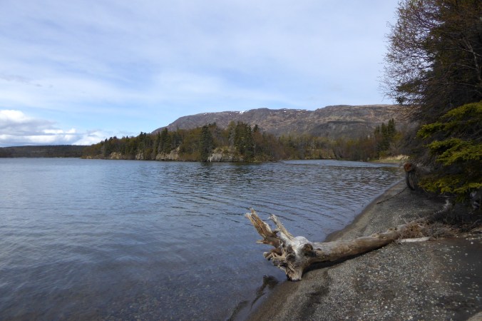
Brooks River begins at the northeast corner of Lake Brooks. The beginning of the river can be seen at center right.
When summer’s long days (Katmai experiences almost 19 hours of daylight at the summer solstice) combine with stretches of clear and sunny weather, the water above this shelf is warmed considerably. When cool, cloudy weather covers the region, the water over the shelf drops in temperature. Wind across Lake Brooks can also help stir the lake, perhaps even breaking the thermocline between warm water on the surface and the cold water underneath. Even a rough comparison of weather and the river’s water temperature shows a clear correlation.
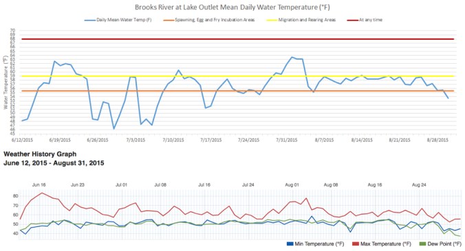
On the weather graph (bottom), the red line represents the daily maximum temperature, the blue line represents the daily minimum temperature, and the green line represents the dew point. Peaks in the river’s water temperatures roughly correspond with long stretches of warm weather. Weather data graph courtesy of wunderground.com.
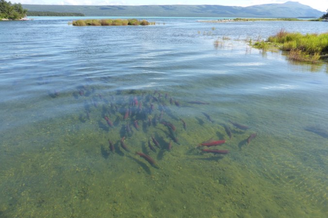
While warmer water temperatures may not affect bears, salmon are sensitive to it. If water temperatures exceed certain limits, then dissolved oxygen levels in the water can drop, increasing mortality rates for adults salmon, fry, and eggs, or altering the timing of migration and spawning. Importantly, water temperature drives incubation time for salmon eggs. Incubation rates for salmon eggs are slower in cold water and faster in warmer water. If the sockeye salmon in Brook River spawned in July, for example, then warmer water would decrease the incubation period for the newly spawned eggs, potentially causing them to hatch too early when no food is available for the fry. These temperatures would also increase egg mortality. Sockeye and coho salmon egg survival plummets when water temperatures reach 14˚C (57˚ F). (See pages 9-15 in ADF&G’s Technical Report 91-1).

This graph displays sockeye and coho egg mortality compared to water temperature. Graph courtesy of the Alaska Department of Fish of Game.
The sockeye salmon that spawn in Brooks River avoid this risk by delaying their spawning until late August and September. Notice how water temperature on the graph plateaus then begins to decrease by the end of August.
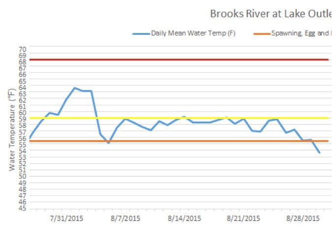
By late summer, day length has shortened by many hours. With less sunlight available to warm the water near the outlet of Lake Brooks, temperatures eventually dip well within ideal thresholds for spawning and egg incubation. The river’s salmon take advantage of these conditions by delaying their spawning until late summer and fall when cooler water temperatures, which continue to drop as fall wanes into winter, slow the salmon eggs’ incubation time. They don’t hatch until very late winter, and the fry don’t emerge from the stream gravel until spring when water temperatures begin to rise again and more sunlight supports more plankton, which feed the young salmon.
Brooks River is a dynamic place. No one week, no one year is the same as the last. Salmon, at least genetically, understand this. They “know” spawning in July would be risky business and probably unsuccessful. Their spawning cycle is timed to avoid the warmest and most variable water temperatures. In this way, every year, Brooks River’s salmon demonstrate their adaptation to variable conditions.

Thank you Mike Fitz for that interesting and detailed explanation as to how and why the water temperatures vary prior to feeding into the Brooks River. Likewise, nice seeing the up close photos of the area around Lake Brooks that one doesn’t get to see from the cam views on top of Mt. Dumpling.
LikeLike
Pingback: Katmai National Park Water Temperature: Exploring the Factors and Impacts - nationalparks.tours