Many years ago, inspired by the complicated and fascinating intersection of bears, salmon, and people at a most unique place, I conceived the idea of a book that captured the story of Brooks River in Katmai National Park.
Part one of The Bears of Brooks Falls explores the establishment of Katmai National Monument, from the moments preceding the largest volcanic eruption of the 20th century to the discovery of the surreal Valley of Ten Thousand Smokes. These events inspired the creation of Katmai National Monument and, soon after, the efforts to expand the park for wildlife like brown bears.
Today, Katmai is most famous for its brown bears. Part two is devoted to their lives as well as the salmon that the bears depend on for their survival. I explore the marvel of the hibernating bear, discover Brooks River from a cub’s perspective, and follow the tribulations and growth of young bears recently separated from their mother. I also ponder how Katmai’s brown bears experience reproduction, competition, hunger, and death.
Few organisms are as important to an ecosystem as sockeye salmon are to Brooks River. These fish face tremendous obstacles and challenges. From freshwater to the ocean and back again, they travel thousands of miles, running a gauntlet of predators to fulfill their destiny. The journey ends when they sacrifice their lives to reproduce. Salmon are Katmai’s keystone, driving Brooks River’s productivity and significance.
In part three, I examine modern humanity’s influence over Brooks River. Humans may be the river’s biggest wildcard. Climate change looms large over the land and seascapes, and people alter the behavior of the bears that make the scene so special. The infrastructure needed to support thousands of visitors and their recreational activities invites conflict with bears. Managing bears and people in such a small area is especially challenging, provoking a decades-long and often emotional debate about the river’s future.
Brooks River’s bears live in a land that straddles the border between the wild and human realms. Their lives are intertwined with ours, and as a result Brooks River is a microcosm for many of the issues facing our national parks. No book has captured this story before.
I’d also love to know what you think of the book. Drop a comment in response to this post, email me, or post a review on the websites of major booksellers.
Origin stories seem to be almost requisite for superhero movies, even for well-known characters. (Like, we all know by now that a radioactive spider bit Peter Parker and Bruce Wayne witnessed the murder of his parents; so perhaps the next time Hollywood decides to reboot their tales, maybe just skip over those parts?) Landscapes, on the other hand? Their origins are not investigated nearly enough.
In my last post, I introduced the glacial origins of Brooks River, perhaps the most iconic wildlife viewing site in U.S. national parks. This was far from the full story though. After glaciers sculpted the land, a series of dramatic changes occurred as the river evolved into its current form. In this online chapter of The Bears of Brooks Falls: Wildlife and Survival on Alaska’s Brooks River, I investigate the river’s most recent origins. Brooks River is a superhero of a landscape, providing a home for bears, salmon, and people for thousands of years.
In the coming weeks, please check my blog and Twitter feed to find details about how to order signed copies of The Bears of Brooks Falls. And, be sure to ask for it at your favorite independent bookstore. The book ships out March 9, 2021.
Qit’rwik
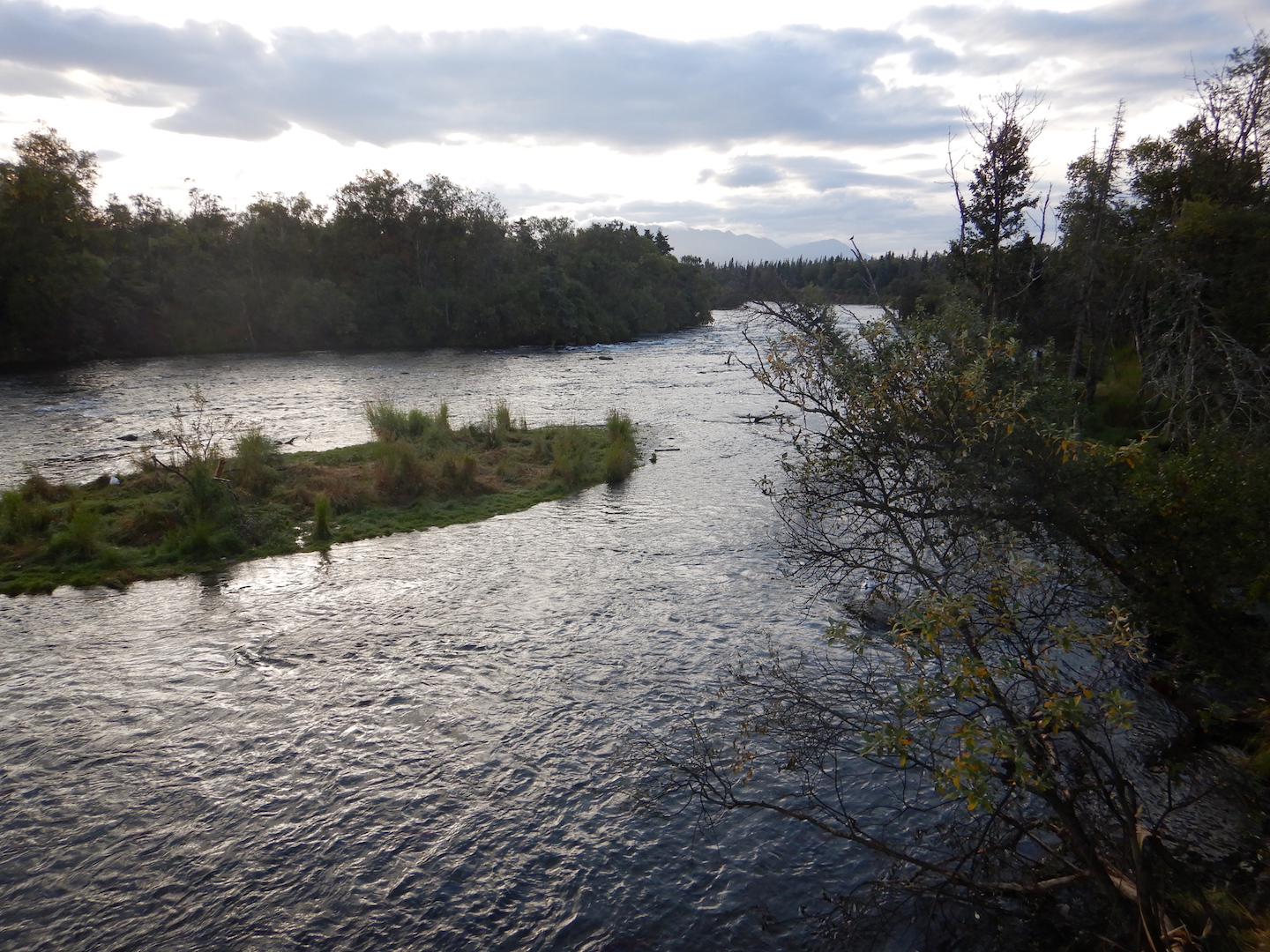
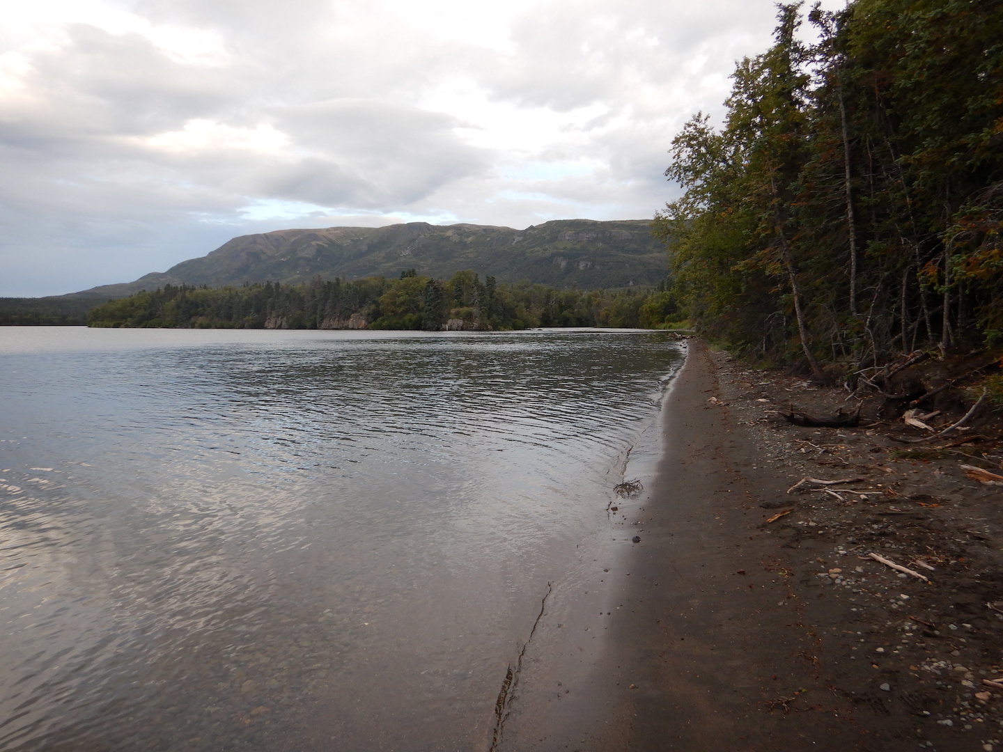
Throughout the years I spent as a ranger at Brooks Camp, I enjoyed exploring the thin ribbon of beach bordering Naknek Lake, especially in spring when the lake was near its annual low point. The beach stretching north from the mouth of Brooks River is one of the most inviting and extensive on Naknek Lake. It’s also temporary—a symbol of the lake and river’s continued evolution.
On a prime May evening in 2015, I make time to explore the changes wrought on the beach by the prior winter’s wind and waves. I exit the line of alder and spruce near the visitor center and walk toward a lake that is dramatically lower than the previous fall. Two wrack lines, built with airy pumice and driftwood flotsam, identify former high water stands from years past. The uppermost borders the very edge of the vegetation line and marked the high water mark in 2012, a year when the lake, or at least its wind-driven waves, rose to the beach’s upper boundary. The other, where the lake reached its maximum volume in 2014, is more than 10 feet closer to the water and a foot lower in elevation. Even with my eyes closed, when walking to the water from the tree line I could find the wrack lines by sound and texture. Pumice and small branches of driftwood roll and crunch underfoot like broken pieces of hard styrofoam. Gravel and sand, in contrast, feel heavy and less hollow.
The beach at Brooks Camp in springtime. Photo looks south toward the outlet of Brooks River.
When my feet reach the water’s edge, I turn right and walk south, approaching the river by paralleling a set of early season bear prints. I stop and face the river where it flows through a narrow channel barely a stone’s throw wide. I’m isolated at the end of a gravel bar, where the river finally meets the lake, and unable to go farther without wet feet. Otter tracks crisscross the sand, while on the opposite shore terns, mergansers, and gulls rest and preen on a bar of pebbles jutting into the shallow lake. They keep a wary eye on me but make no move to fly.
The beach and the gravel bars adjacent to the river mouth are altered by Naknek Lake’s predictable cycle of swelling and shrinking. It is widest in early spring after months of sub-freezing temperatures reduce the lake’s inflow to a trickle, and thinnest in early fall after a summer’s worth of rain, snowmelt, and glacial runoff fill the basin. In late summer, I couldn’t come close to approaching this area without swimming. I stand on dry ground about six feet lower in elevation than last autumn’s wrack line. A multi-year time lapse of this spot would record an annual cycle—the lake swelling with onset of spring thaw and shrinking when widespread freezing temperatures return in autumn. When flooded this spot is patrolled most often by hungry bears who swim in search of carcasses of spawned-out salmon.
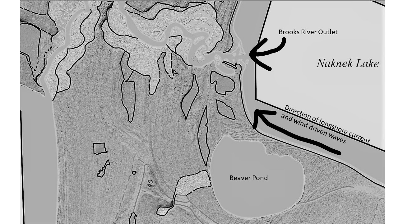
Wind-driven waves periodically reorganize the beach and river mouth. Temporary longshore currents, driven by strong easterly winds, purge sediments from the lakeshore south of the river and carry them northward. Storms shoal the unconsolidated sand and gravel into bars and spits, altering the flow of the river where it meets the lake.
Although these changes can be dramatic, the winter of 2014-2015 brought only a subtle reorganization to the river mouth. More sediment was deposited on a gravel bar near the tree line neighboring the lodge. On the south side of the river, a substantial spit grew a few feet northward. This spit arcs upstream into the river to create a calm, protected cove where waves do not reach, a convenient place for Brooks Lodge and National Park Service staff to moor boats away from the lake’s waves. I wondered how far this fan of gravel might one day extend. It’s grown a little wider every year of my observations.
An iteration of the spit and sheltered lagoon behind it has featured prominently at the river for hundreds of years, perhaps longer. In the Alutiiq (Supiaq) language, Brooks River is known as Qit’rwik. Pronounced kettiwick or kittiwick, Qit’rwik is a descriptive word that translates to a “sheltered place on the water.” More generically, a qit’rwik can refer to any lagoon or protected bay that is connected to open water and can provide shelter for a boat.
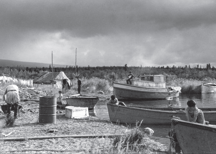
In September 1940, Mount McKinley National Park Superintendent Frank Been and U.S. Biological Survey biologist Victor Cahalane visited Katmai National Monument. They witnessed Alaska Natives, who traveled from the King Salmon and Naknek area to Brooks River, harvesting salmon. Mary Jane Neilson participated in those harvests and later recalled, “While we were at Qitirwik…Grandma…and our parents would catch fish to split and dry. The men built racks to dry the fish at the mouth of Brooks River on the south shore. Fish racks were still up in the 1950s when the National Park Service became more visible in the area.” Motorboats had replaced traditional mammal skin kayaks by then, but the river mouth, partly sheltered and enclosed by spits of sand and gravel, still provided people a safe harbor from wind-driven waves and a convenient spot to prepare and dry salmon.
The Melgenak and Angasan families at Qit’rwik in 1950. National Park Service Photo.
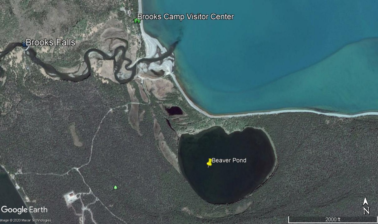
Many a qit’rwik’s story is locked in place by fickle, shifting sediments and the evolving nature of Katmai’s lakes. South of the river mouth a small pond hides in the forest. Before the National Park Service constructed a one-lane road to it in 2014, I occasionally visited the Beaver Pond to escape Brooks Camp’s bustle or simply for a change of scenery. Walking south along the lakeshore from the river mouth, a hedgerow of alder, birch, and poplar trees obscured the pond and any resting bears in the vegetation, but the actual bushwhack to it was short when I chose the route correctly.
At first glance the pond is like many others in the area. It is moderately sized and oblong, measuring about 2000 feet east to west and 1600 feet north to south. Beavers, as its nickname suggests, have used it for decades although the pond is not a product of beaver industry. There is no dam to hold its water back nor does much flowing water enter it. The pond is fed primarily by rain, snow, and slow seepage from adjacent marshes.
Perhaps thousands of similarly-sized ponds dot western Katmai and the adjacent Bristol Bay lowlands, most of which are glacial kettle holes, features that form where stranded blocks of glacial ice were surrounded by till and outwash. As the isolated ice melted, they created enclosed basins that filled with water. Despite its superficial resemblance, Beaver Pond is not a kettle either. Its history began in the shifting sands and pebbles along the Naknek Lake shoreline.
The Beaver Pond occupies an open embayment that was once cleaved into the glacial outwash bordering Naknek Lake. At first, it may have been exposed to the full force of wind and waves, not unlike the modern-day beach adjacent to the lodge and visitor center. Strong winds funneling across the Aleutian Range and down Iliuk Arm did not permit the bay to remain open indefinitely, however. Wind stirred waves pushed gravel and sand westward from the raw, highly erodible glacial sediments near the Iliuk moraine. These collected into an overlapping series of northward-growing horsetail shaped spits. Eventually, the bay was encircled and permanently separated from Naknek Lake as the spits migrated and thickened toward Brooks River. The Beaver Pond’s divorce from Naknek Lake may have taken decades or centuries, to finalize. All the while, the growing horsetail-shaped spits created a series of long-lasting qit’rwiks.
The Beaver Pond’s formation is just a small part of a more ancient story, one that explains how Brooks River evolved and how it became an important place for people.
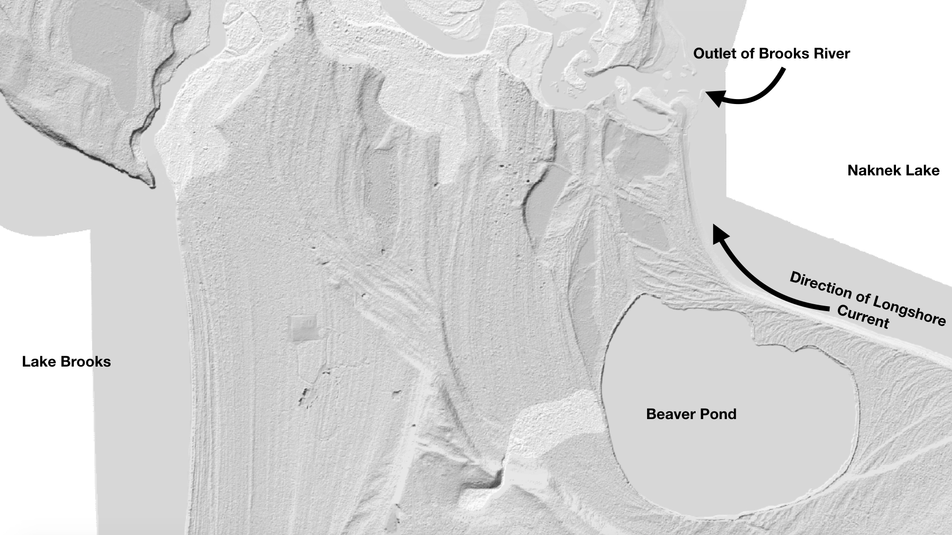
The Beaver Pond is a former embayment of Naknek Lake. It was separated from the lake by longshore currents that deposited nearly parallel arcs of sediment from east to west as seen in this LIDAR imagery.
Brooks Lodge and the NPS visitor center sit on a lumpy terrace about 12 feet higher than the highest historical stands of Naknek Lake. From the lodge, the terrace’s geometry is apparent. Shaped by waves on one side while the river carved into the opposite shore, it tapers wedge-like toward the river mouth. This is just one of the many old terraces undulating throughout the river corridor from the Beaver Pond to Dumpling Mountain and upstream to Lake Brooks. At first glance, especially when bushwhacking in the forest’s dim confines, the terraces seem haphazardly placed, but a closer look reveals a roughly concentric shape to many. Between the river mouth and Lake Brooks, their concave faces open toward Naknek Lake and climb in a stair step manner—a series of short, steep rises each topped with a relatively flat bench. The terraces continue dozens of feet up nearby hillsides.
When the large Ice Age glaciers vacated Katmai, a series of glacial lakes began to occupy the excavated basins. Such lakes are far from static and often subject to rapid change, filling quickly and sometimes draining even quicker. Those in Katmai rose far above the modern counterparts; their waters held back by temporary ice dams or raw, erodible, and sparsely vegetated terminal moraines.
Lake Brooks was perhaps the first lake in the Brooks River area to undergo a rapid transformation. At the greatest extent of the Newhalen stade glaciers, 23,000 to 20,000 years ago, ice filled two-thirds or more of Naknek Lake’s basin, extending lobes around the north and south sides of Dumpling Mountain. The southernmost lobe pushed completely across the area now covered by Lake Brooks. When this glaciation waned, Lake Brooks began to fill the void. Unlike today, though, when Lake Brooks feeds Brooks River and Naknek Lake, this first iteration of Lake Brooks didn’t find connectivity with an infant Naknek Lake. It was walled in by ice to the east, mountains to the north and south, and a newly deposited terminal moraine to the west. Ancestral Lake Brooks had nowhere to go but up.
Evidence for its rise is preserved in wave cut terraces that lie stranded on hillsides. The highest such terrace sits near the western end of Lake Brooks. At more than 200 feet in elevation, it is 140 feet above the lake’s modern level. At its greatest height, liquid water likely occupied only the far western end of the Lake Brooks basin and only for a short period of time. Filled to capacity and separated from the Naknek Lake basin by ice, Lake Brooks spilled over the moraine on its western shore and drained west through the Bristol Bay lowlands. At the same time, a proto-Naknek Lake began to form in front of the glacial lobe north of Dumpling.
The ice divide between the lakes was short lived and the lakes merged after the Newhalen-aged glacier receded sufficiently to release Lake Brooks’ water into the Naknek basin. With the ice divide gone, Naknek Lake captured and reversed the flow of Lake Brooks.
Naknek Lake now covers 150,000 acres and is the largest lake wholly contained within a U.S. national park. Six large lakes (Brooks, Coville, Grosvenor, Hammersley, Idavain, and Murray), Savonoski River, Ukak River, and countless small ponds and creeks feed it. Yet Naknek Lake is a shell of its former self. It changed just as dramatically as Lake Brooks, if not more so, although these changes are far from finished.
Naknek Lake currently sits at a modest 42 feet in elevation, but in the wake of glacial retreat, the Pike Ridge moraine at the lake’s west end was a formidable barrier to water. Before any outlet could drain the lake, water had to rise high enough to overtop this earthen dam. It did only after reaching heights not seen before or since. Wave cut terraces and stranded beaches adjacent to the lake exist at 190 feet above sea level in the uplands adjacent to the lake. At full pool, Naknek Lake was as much as a third larger than today. It swallowed half of the Savonoski River floodplain; annexed Lake Brooks (el. 72 feet), Lake Coville (el. 108 feet), and Lake Grosvenor (el. 108 feet); made islands out of Dumpling Mountain and Mount La Gorce; and drowned the future site of Brooks Falls underneath dozens of feet of frigid water. For thousands of years after glaciers left, the lake remained so high that no hint of Brooks River existed.
Slowly, Naknek River’s down cutting reduced the Naknek Lake’s storage capacity. Islands merged. Rivers lengthened. Lake basins separated. All the while, waves carved terraces onto mountainsides during prolonged pauses in the draining. But the future site of Brooks River remained an abyss. Terraces higher than 98 feet in elevation are capped with volcanic ash from an eruption twelve to thirteen thousand years ago, indicating the land adjacent to the modern river mouth was still below as much as 56 feet of glacially cold water at the time.
After Naknek Lake captured its water, the Lake Brooks basin mirrored the changes of greater Naknek Lake for thousands of years until they separated for good between 6,500 and 5,500 years ago. Then, lowering lake levels exposed a dike of igneous rock in the path of the water flowing from Lake Brooks to Naknek Lake. At the surface after thousands of years or subaqueous inconsequentiality, and unlike the veneer of unconsolidated glacial till and lake sediments covering much of the Brooks River area, this bedrock was not easily erodible. Meanwhile, Naknek Lake continued to drain away as its outlet, Naknek River, eroded through the terminal moraine serving as the lake’s dam. The gently lapping water of Lake Brooks lacked the erosive energy to remove its newfound bedrock dam, however. Lake Brooks, perhaps for the first time ever, became locked in place.
Brooks River begins its journey to Naknek Lake at the northeast corner of Lake Brooks.The head of Brooks River. The line of ripples across the center of the photo mark the bedrock shelf that maintains the level of Lake Brooks.
Nearly all the dry land surrounding Brooks River today was exposed when the first semblance of a river formed five thousand years ago, but water levels were still high enough that the early river was very short, merely a wide area of slowly flowing water between the diverging basins. Less of a river than a narrow strait, the area quickly became an important resource for animals and people.
The oldest evidence of people known from the Alaska Peninsula comes from a squeeze of land about 75 miles southwest of Brooks River. Ugashik Narrows separates north and south Ugashik Lakes on the Alaska Peninsula National Wildlife Refuge, and is one of the most popular sport fishing destinations in all of southwest Alaska. Evidently, its popularity extends much further back in time. Artifacts at the narrows reach 9,000 years in age, but the first people there may not have been fishing much. Chipped stone tools suggest the first residents at Ugashik Narrows came for caribou, animals that would’ve moved efficiently across the open, tundra-like habitat, browsing on lichens in winter and green forbs in the summer. Instead of swimming across the lakes at Ugashik, the caribou crossed the stream at the narrows. People let the land funnel their quarry.
A similar dynamic occurred at the Brooks River narrows circa 3000 BC. A caribou herd moving toward the river narrows faced a choice: swim across miles of open lake water or follow the land. Caribou are good swimmers, but like many terrestrial mammals they often stay high and dry when given the option. The first people at Brooks River, like those at Ugashik Narrows, knew this well. They followed the migratory herds to the emergent Brooks River or established camps there and waited. Archeological excavations uncovered large stone lances and knives—weapons used to hunt large mammals—from Brooks River’s earliest human inhabitants. Caribou bones within their campsites prove they were successful.
The currently available archeological evidence suggests, curiously, that salmon were not a major food source for the earliest cultures at Brooks River even though salmon may have colonized Katmai’s lakes soon after they formed. Analysis of sediment cores from Nonvianuk Lake north of Brooks River indicate the presence of anadromous salmon there as much as 10,000 years ago, but no direct evidence of this yet been obtained for Naknek Lake so far back in time. The placement of the earliest camps at Brooks River are away from what would have been the water’s edge at the time, so if salmon were present when the first people arrived, perhaps they weren’t abundant enough to target or the strait between the Lake Brooks and Naknek Lake basins was too challenging to fish successfully.
No matter the reason for the lack of piscivory, free passage for salmon through Brooks River was short lived. As Naknek Lake continued to recede, the strait evolved into a river. Approximately 4,000 years ago the lengthening river uncovered a ridge of sedimentary rock less than a mile downstream of Lake Brooks. At first, Naknek Lake remained high enough that barely a ripple tumbled over the hard conglomerate. Perhaps it was unnoticeable to the salmon migrating in the young river. The ripple grew year by year, growing taller as Naknek Lake withdrew. By 3,500 years ago a distinct plunge formed, one high enough to temporarily impede salmon migrating upstream to spawn. Brooks Falls had emerged.
Although the scene appears timeless, Brooks Falls is a very young geologic feature.
I like to imagine a qit’rwik from long ago, a harbor that perhaps inspired the proper name, Qit’rwik. The former waterfront property hides today within the surrounding forest with artifacts from previous cultures buried in the thickening duff. That qit’rwik foreshadows the fate of Brooks Lodge, the rangers’ cabins, the campground, and the visitor center. Could the newly conceived gravel bars at the river mouth, which seem so ephemeral at first glance, become a future qit’rwik as the river continues to evolve? Some iteration of Brooks River and its adjacent lakes will remain long into the future. It won’t be the same, but it’s far more likely to outlast our cultures than we are to outlast it.
References:
Brooks River known as Qit’rwik and meaning of word: Helen Lons email to Katmai National Park Staff. 2007.
In September 1940, Mount McKinley National Park Superintendent Frank Been and U.S. Biological Survey biologist Victor Cahalane visited Katmai National Monument: Norris, Frank B. 1996. Isolated Paradise: An Administrative History of the Katmai and Aniakchak National Park Units. National Park Service. Pg. 60.
Mary Jane Neilson quote: Neilson, M. J. 2005. The Pelagia Story. Unpublished Masters Thesis. University of Alaska Fairbanks. P. 43.
Definition of kettle hole: Hambrey, M. and Jurg, A. 2004. Glaciers, 2nd Edition. Cambridge University Press.
These collected into a series of lengthening beaches, which migrated and thickened toward Brooks River into horsetail shaped spits: Hults, C.P. 2016. Draft Geomorphic Map of the Brooks River Area and Part of the Road to Valley of Ten Thousand Smokes. Natural Resource Report NPS/NRSS/GRD/NRR-2016/. National Park Service, Alaska Regional Office, Anchorage, Alaska. LIDAR imagry of the Brooks River area clearly shows the land’s geomorphology and can be viewed at http://maps.dggs.alaska.gov/elevationdata/#-17339224:8083535:14.
Age of Beaver Pond: The ages of the spits encircling Beaver Pond are not precisely known, but are most likely young. Some are perhaps fewer than three hundred years old. The elevation of sediments north of the pond is slightly higher than the modern day lake elevation (13 m). The sediments also lack pre-Russian contact archeological artifacts that would indicate an earlier origin.
Lake Brooks spilled over the moraine on its western shore and drained directly on to the Bristol Bay lowlands: Ibid. Hults, C.P. 2016.
Timeline of Lake Brooks/Naknek Lake separation and former elevation of lakes: I relied heavily on the elevations and summary in Hults, C.P. 2016. It is also explained in Dumond, D. E. 1981. Archeology on the Alaska Peninsula: The Naknek Region, 1960-1975. University of Oregon Anthropological Papers. No. 21.
Naknek Lake was certainly lower in elevation than Lake Brooks, perhaps as low as present day: Ibid, Hults. 2016. After Naknek Lake captured Lake Brooks, one last push of ice formed the Iliuk moraine around 20,000 years ago. Discharge from this brief advance formed the broad spruce-covered outwash plain south of Brooks River. Braided drainage channels on its surface indicate the outwash plain was deposited on land, not under a lake, and terraces as high as 68 meters are conspicuously absent along Lake Brooks’ eastern shoreline.
At full pool, Naknek Lake was as much as a third larger than today: This is my rough guess based on the minimum combined surface areas of Naknek, Brooks, Coville, and Grosvenor Lakes.
Wave cut terraces at 59 and 57 meters above sea level, respectively, indicate the lake was once much higher and more extensive: Curiously, isostatic rebound is not believed to have significantly altered the elevation of the terraces. Kaufman, D. S., and K. B. Stillwell. 1995. “Preliminary Evaluation of Post Glacial Shorelines” in Geologic Studies in Alaska. Dumoulin and Gray, Editors. U.S. Geological Survey.
All terraces higher than 30 meters in elevation are capped with volcanic ash from an eruption twelve to thirteen thousand years ago: Ibid, Kaufman and Stillwell. 1995.
Artifacts at Ugashik Narrows are approximately 9,000 years old: Dumond, D. E. 1987. Prehistoric Human Occupation in Southwestern Alaska: A Study of Resource Distribution and Site Location. University of Oregon Anthropological Papers. No. 36.
I first traveled to Brooks River within Katmai National Park in early May 2007, and today it’s hard for me to imagine my life without it.
On the morning of my first flight to Brooks Camp (which is only accessible by boat, plane, or a very long, boggy, buggy, and rough cross-country hike), fellow rangers and I hauled our clothing, equipment, and months of food to the floatplane docks along Naknek River in the small town of King Salmon, a sprawling community surrounding an airport and mothballed U.S. Air Force base. We were excited and enthusiastic to begin the adventure, but few of us, I believe, truly understood what we were getting ourselves into. I certainly didn’t. Not quite a greenhorn when it came to wild areas, I had never experienced a landscape like this.
Immediately after takeoff, I gazed out the window of our small plane, my eyes transfixed on what many people would describe as nothing. King Salmon’s few houses, roads, and infrastructure quickly yielded to tundra and scattered spruce trees. This was land devoid of permanent human habitation. Cross hatching animal trails led to unknown destinations. I saw wildly meandering creeks, too many ponds and lakes to count, and a horizon bounded by unnamed mountains.
After twenty-five minutes of flying, the pilot landed smoothly on Naknek Lake’s calm surface, and we taxied to an empty beach in front of the few scattered buildings marking Brooks Camp. With the help of fellow staff, I hurriedly unloaded and stashed my gear inside a nearby tent frame cabin and began to settle in.
Later that evening, Jeanne, my then girlfriend and now wife, and I returned to the beach. I had just finished a winter job at Death Valley National Park, where daily temperatures had already risen above 100˚F, but Brooks Camp looked like winter couldn’t decide to stay or go. Leaves had not broken bud, thick blankets of snow clung to the mountains, and the underground water pipes to our cabin remained frozen. I walked wide-eyed, trying to take in the totality of the scene—the turquoise color of Naknek Lake, the snow-capped mountains, the pumice-strewn beach, a set of bear prints in the sand—when Jeanne waved her arm toward the horizon and remarked, “This is spectacular.”
I don’t recall if I responded or not. Doesn’t matter, because she was right. I had never looked upon land so empty yet so full.
Katmai and Brooks River are unlike any other place. But relatively little has been published about the bears, salmon, and humanity that intertwine at the river. In 2014, I first imagined an idea of writing a book about Brooks River and its inhabitants. In 2016, I began to work on it in earnest and this year I finished the manuscript. I’m pleased to announce my book, The Bears of Brooks Falls: Wildlife and Survival on Alaska’s Brooks River, is available for pre-order. It ships out in March 2021 via Countryman Press. In eighteen chapters, the book strives to explore the ecology of the river’s famed brown bears and salmon as well as the complex relationship people have with the place.
Part one focuses on the colossal eruption of Novarupta Volcano in 1912 and the discovery of the Valley of Ten Thousand Smokes. This event reshaped the area’s history and led to the establishment of Katmai National Monument in 1918, a time when the national park idea was still fledging.
Today, Katmai is most famous for its brown bears. Part two is devoted to their lives and the salmon the bears depend on to survive. I explore the marvel of the hibernating bear from a den on Dumpling Mountain, discover the river from a cub’s perspective, and follow the tribulations and growth of young bears recently separated from their mother. The brown bear mating season provides the chance to learn how bears compete during one of the most important times in their lives. Writing about the bear hierarchy, I consider how this social structure provides advantages to bears who live in an unfair world. Katmai’s brown bears experience hunger in a profoundly different way than people. They must eat a year’s worth of food in fewer than six months to survive hibernation. Their feeding choices and habits reflect highly tuned adaptations to take advantage of summer’s ephemeral bounty. And, the poignancy of a cub’s death, one witnessed by thousands of people on the park’s webcams, provides the chance to reflect on the end of a bear’s life.
Few organisms are as important to an ecosystem as salmon are to Katmai. Leading Odyssean lives, sockeye salmon face tremendous obstacles and challenges. From fresh water to the ocean and back again, they travel thousands of miles, running a gauntlet of predators to fulfill their destiny. Weakened by their freshwater migration and subsisting without food for weeks, the journey of Brooks River’s sockeye ends when they sacrifice their lives to reproduce. They are the ecosystem’s keystone, driving the river’s abundance and significance.
In part three, I examine modern humanity’s influence over Brooks River. Humans may be the river’s biggest ecological wildcard. Climate change looms large over the land and seascapes, and people alter the behavior of the bears that make the scene so special. The infrastructure needed to support thousands of visitors and their recreational activities invite conflict with bears. Managing bears and people in such a small area is especially challenging, provoking a decades-long and often emotional debate about the river’s future.
The Bears of Brooks Falls: Wildlife and Survival on Alaska’s Brooks River is an exploration of brown bears and salmon in one of the Earth’s last fully intact ecosystems. It’s an honest and deep dive into issues surrounding the role people play in the riverscape and Katmai National Park. And, I’m so excited for you to read it, and I hope you’ll consider adding it to your bookshelf.
This blog has been relatively dark over the last year, not because I hadn’t intended to write for it but because I frequently had other writing duties to fulfill. Afterward completing one task, it was often easier to space out at the end of the day than concentrate on writing something that approaches partial intelligence.
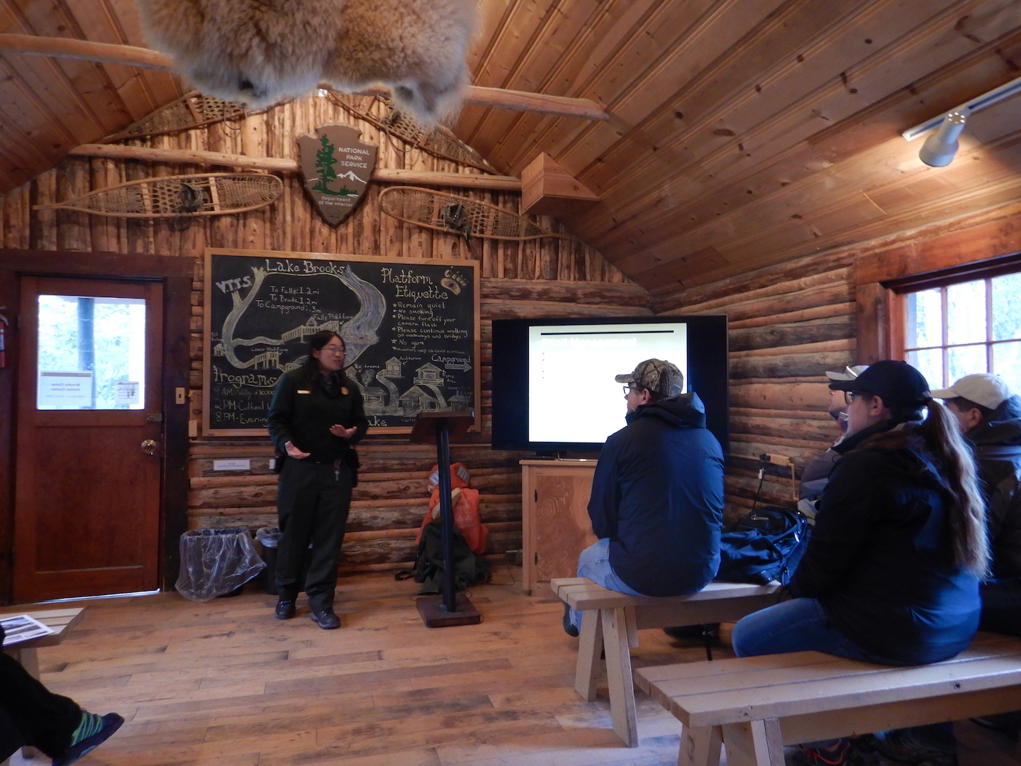
I want to share a little of what I have been writing though. Each Tuesday, I cohost a question and answer session in the comments on explore.org’s Brooks Live Chat channel. It’s an AMA about anything related to Katmai National Park’s bears and salmon. Many people submit your questions in advance, which allows me to answer them with greater detail than a question asked on the spot. Below are my answers to those questions during the Q&As for early September.
Be sure to join the Q&A every Tuesday from 5 -7 p.m. Eastern in the Brooks Live Chat channel, and if you prefer to chat in sentences limited to 200 characters, then join the bearcam conversation on explore.org’s Brooks Falls YouTube feed.
September 1, 2020
I’d like to talk about the “Beaver Pond,” which Kathryn asked about via the Ask Your Bearcam Question form. “I’ve often looked at photos of the [Beaver Pond] and wonder if any salmon can make it to the pond and if any of you have seen bears fishing or hunting around the pond?”
The “Beaver Pond” is located about fourth-tenths of a mile south of the outlet of Brooks River. A road provides an avenue to get near there although there is no developed trail to the pond’s edge. Bears use the area but mostly as part of their efforts to get to and from Brooks River because the pond is inaccessible to salmon.
The Beaver Pond in relation to Brooks River
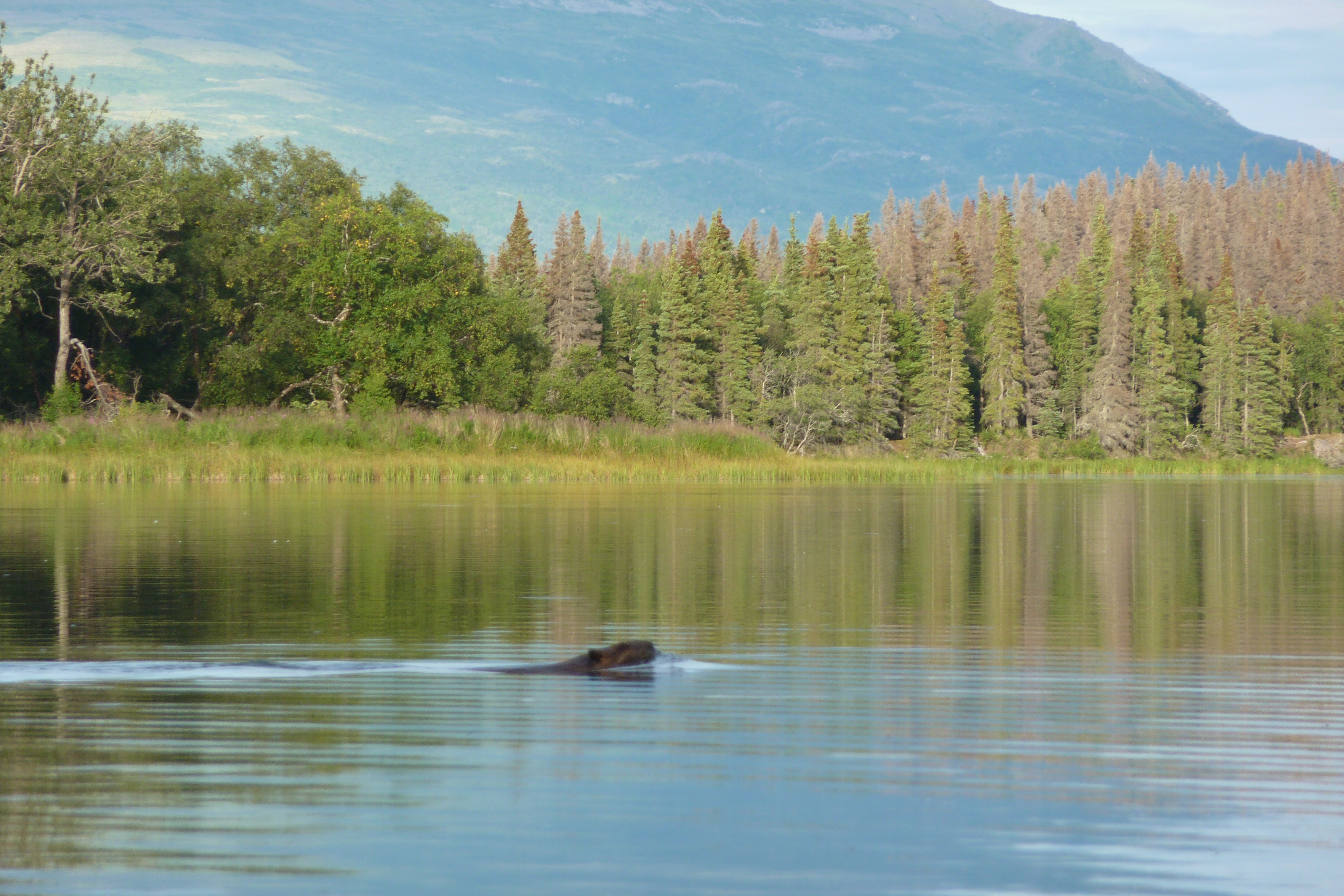
A beaver at the Beaver Pond
Beavers maintain a lodge on the pond’s north side and a grass-covered dike (an old beaver dam) lines much of that area. But, the Beaver Pond isn’t a true beaver pond in the sense that its formation was the direct result of beavers. It was once part of Naknek Lake and has since been cut off by the sediments deposited by wind driven waves.
The beaver pond was once a cove on the edge of Naknek Lake. Strong easterly winds create waves that erode the gravel shoreline to the southeast of Brooks River. The waves carry gravel and sand northwest toward Brooks River. Over time, a horsetail shaped beach began to encircle the cove. This image below is from an unpublished geologic report about the Brooks River area. Note the concentric ridges along the lakeshore near the beaver pond. These are the beach ridges that cut off the beaver pond from Naknek Lake.
This process is similar to what we see at the river mouth, especially in the “spit” area that partly encloses a lagoon-like area rangers call the boat cove. The boat cove may be destined to become a small pond or marsh like the wetlands between the river mouth and the beaver pond today, although the mouth of Brooks River is more exposed to direct blows from wind-driven waves than the beaver pond area. Strong storms can quickly rework and reshape the gravel at the river mouth.
In the above image, the parallel lines farther inland are old beaches as well, although they weren’t formed by longshore currents. Instead, they mark the former levels of Naknek Lake and Lake Brooks. Naknek Lake has been slowly lowering in elevation as Naknek River cuts through the glacial sediments that dam the lake.
Although we don’t know exactly what the Brooks River mouth area will look like in the future, we definitely know it will not look the same.
Jen wrote in wondering about the line-up of salmon we sometimes see below the river watch cam and asks, “Has that behavior been noted before?” And, “What criteria initiate egg-laying?”
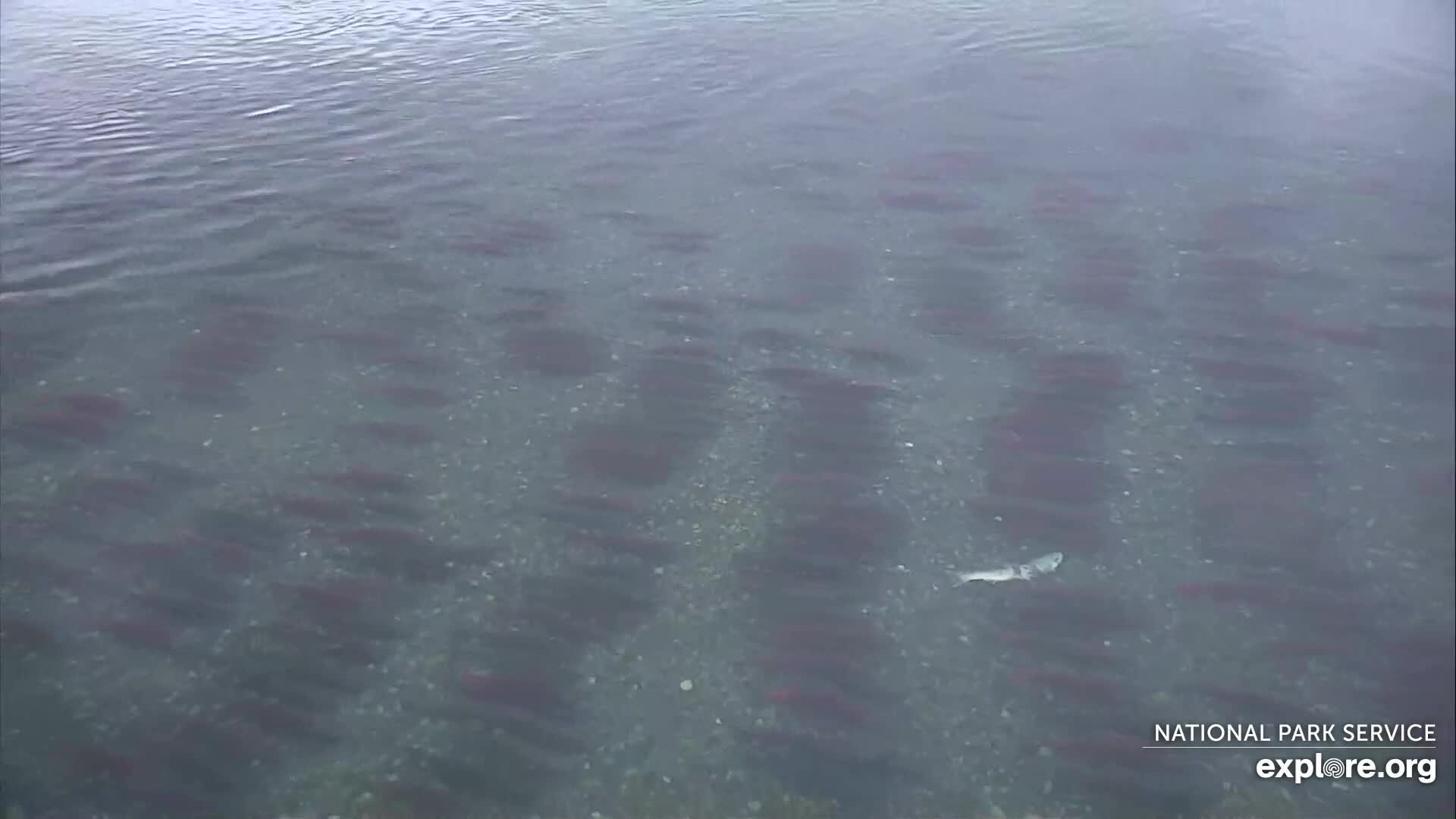
This is the formation that Jen refers to.
Parallel lines of sockeye salmon in Brooks River. The fish are facing upstream and in this image the current flows from right to left.
Sockeye salmon line up in fairly parallel rows frequently in late summer in the lower Brooks River. Until this year, however, with more salmon using the channel below the river watch cam, we haven’t been able to see this on the cams very well. Although this is not a new phenomenon at the river, I haven’t been able to find an explanation for it. We know the salmon are staging (waiting for the right time to spawn) but I don’t know if lining up in rows gives them any sort of advantage. It may be the most efficient way to sort themselves or there could be some social cue among the fish that prompts the formation. It’s a beautiful feature of the lower river in late summer.
Regarding Jen’s second question, a female salmon lays her eggs in nests she constructs by fanning the gravel with her tail. This action winnows away fine sediments that might hinder water flow (and hence dissolved oxygen) around her eggs. She’s looking for gravel of the right size and in areas of the river with consistent water flow. Males will fan the gravel occasionally too but they play no role in nest construction. Once the female determines her nest is suitable and she’s accompanied by a suitable male, she’ll release her eggs directly into the nest while the male releases his milt. In this way, it is the female who determines when to lay eggs.
LoveTheBears writes, “I understand that there is an area designated for cleaning any caught and kept fish. What happens with the discarded fish parts?”
There used to be a public fish-cleaning building at Brooks Camp. The first iteration wasn’t much more than screened-in shelter with a bucket on the floor where people disposed fish entrails. It was later replaced by a more substantial log cabin style building where people could clean their fish. Today though, there is no public fish cleaning facilities at Brooks Camp and the public is prohibited from cleaning fish within 1.5 miles of Brooks Falls. People can keep one fish per person per day downstream of the bridge, but they must take it immediately to the Fish Freezing Building (the old fish cleaning building) and place it in a freezer. It must remain there until you depart Brooks Camp.
Although no bears at Brooks River are currently conditioned to seek human food, it hasn’t always been this way. In the 1960s and 1970s, many bears learned to associate people with food and sought opportunities to get at human foods at Brooks Camp. The fish cleaning buildings were part of the issue along with open dumps, outdoor burn barrels for garbage, and overall lack of awareness and regulations about proper food storage in bear country. As part of the effort to reduce the risk of bears becoming food conditioned, the NPS got rid of the public fish cleaning facility.
Bears easily learn and remember any trick that allows them to find food. Therefore, we must remain constantly vigilant to ensure that bears don’t learn to associate us with fish. The NPS and the State of Alaska implemented somewhat strict fishing regulations in the 1990s, which has greatly reduced the number of incidents when bears have learned to associate people with fish. Eliminating public fish cleaning facilities and prohibiting fish cleaning within 1.5 miles of Brooks Falls inconveniences some people but it is a big step toward protecting bears.
September 8
Angela writes, “We were talking about hibernation in the chat thread and wondered if it is necessary for bears to hibernate. We understand that bears at Katmai hibernate, but were wondering if bears in captivity also hibernate or if because there is a regular food source, the need to hibernate isn’t triggered?”
Hibernation exists along a spectrum rather than being an either/or behavior. Some mammals such as arctic ground squirrels are obligate hibernators, meaning they hibernate regardless of ambient temperatures or access to food. Bears experience a type of facultative hibernation. Given the right circumstances, bears needn’t hibernate to survive winter.
Each year, at least some black bears in mild climates (Sierra Nevada foothills, coastal plain of the southeast U.S., and Big Bend National Park to name a few) remain active all year. These are generally adult males. Similarly, a few adult male brown bears are active on Kodiak all year. Mild temperatures and at least some food allow these bears to remain out and about.
In North America, only pregnant female bears must enter a den and it isn’t because they must hibernate. Bear cubs are born so small and physically immature that they need many weeks of additional development before they are mobile enough to travel with mom. This is even true of polar bears who utilize the winter season to hunt seals on sea ice. Instead of heading out on to sea ice in early winter, pregnant female polar bears, just like all other pregnant North American bears, head to dens to give birth.
Although a handful of bears remain active all year, especially in more southerly populations compared to Katmai, hibernation is a bear’s best energy conservation strategy. It makes sense for nearly all bears to hibernate during winter when food is either very limited or non-existent. For those bears who stay active (other than polar bears), their metabolism and activity rates are much lower than summer. Winter activity, therefore, doesn’t mean that bears are as active as they would be in summer. So even captive bears may ignore food and water provided to them, relying more on their hibernative physiology to survive.
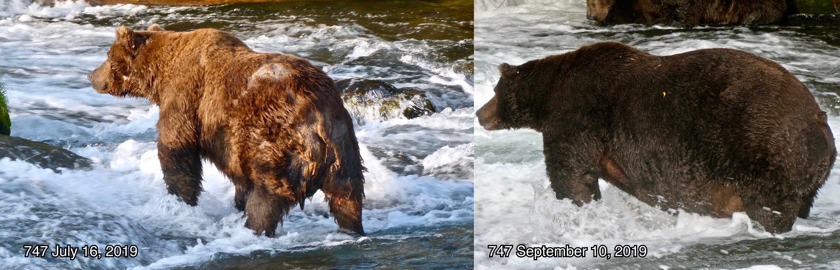
Erin asks, “747 is a huge bear. Is he the biggest bear seen at Brooks River? Have there been bigger bears in the past?”
As I’ve said and written many times, 747 is a giant of a bear. He is the most massive bear I’ve ever seen and we should not take his presence for granted. If 747 were to disappear from the river, it may be a long while before we see another as big as he. Last year, 747’s was estimated to weigh more than 1,400 pounds.
747 from Fat Bear Week 2019
Each year, there are comparably sized bears in Katmai and at Brooks River. I’ll start by listing three of the currently seen bears who approach 747’s size class and then highlight two who might have approached it in the past. Only the largest adult males are comparable.
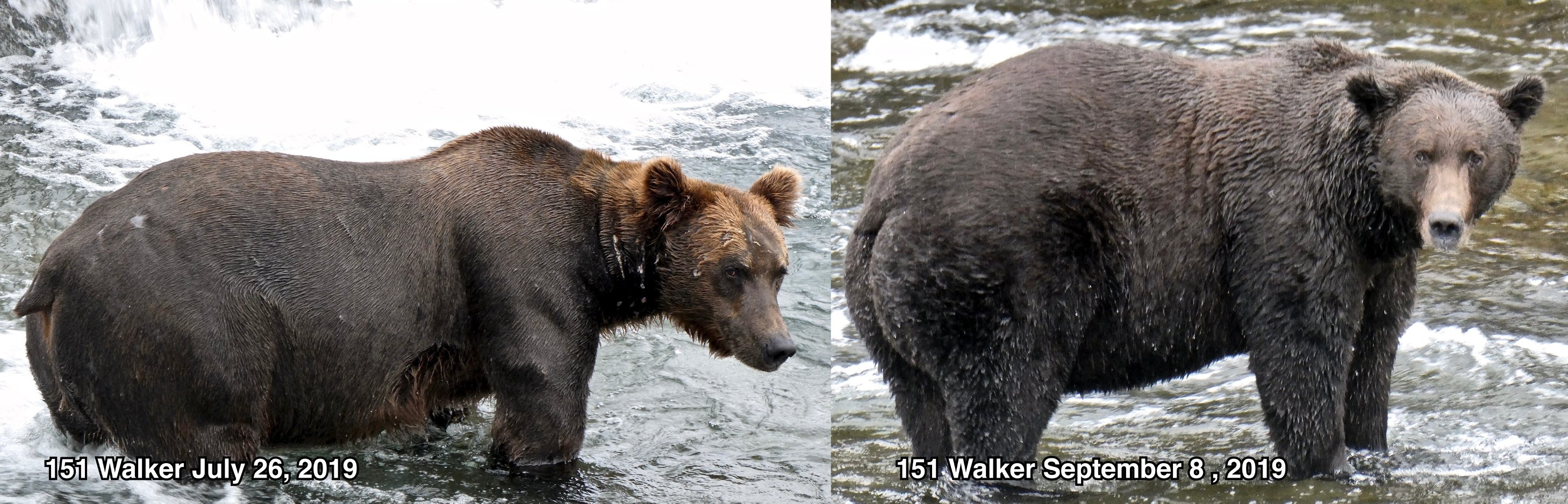
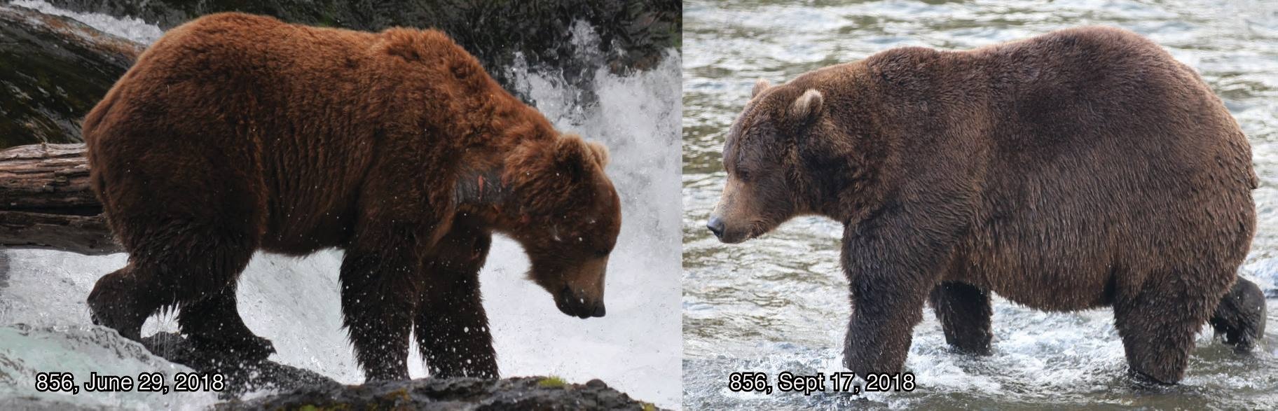
Right now 32 Chunk, 151 Walker, and 856 are close to 747’s size (at least within 300 pounds or so). They certainly rival him when measured by height and length. Each of these bears seem smaller to me than 747, but looks can be deceiving. Size is also an important determinate of dominance in the bear world. It is not absolute though. While 747 is more dominant than Chunk and Walker, 747 consistently yields to 856.
32 Chunk from Fat Bear Week 2019
151 Walker from Fat Bear Week 2019
856 from Fat Bear Week 2018
In the past, Brooks River has hosted some very big bears. While I never had the opportunity to see Diver in person, he was reportedly extremely fat and large in his heyday during the 1980s and 1990s. Look at this photo as an example.
In 2007, the most dominant bear I saw at the river was 24 BB. He was very tall and long–so a massively framed bear. He didn’t use Brooks River in late summer though so we never got to see BB at his peak size for the year. BB behaved much like 856. He asserted his dominance frequently and spent less time fishing than 747 does today, so he might not have been as heavy as 747 but the potential was there.
BB in July 2007
Marlene writes, “856 is getting older. I am wondering if he will know when he no longer can hold the top spot or do you think there will have to be a confrontation?”
856 has been the river’s most consistently dominant bear since 2011. Like all bears, 856 is great at weighing risk versus reward. For him, the overall risk of confronting other bears is low and provides great reward in the form of access to food, fishing spots, and mating opportunities, because other bears recognize his dominance. 856 will use that to his advantage as long as he can.
His high level of dominance is tied to his health and fitness. He’s a large bodied bear so will remain relatively dominant no matter what but he needs to maintain his good health and fitness in case another bear challenges him or is unwilling to yield. 856 might fall from the top of the hierarchy if he is defeated in a fight by another comparably sized bear.
His reign as the river’s most dominant bear could end in another way though. He might not feel up to the challenge.
In July 2017, 856 was an infrequent visitor in July and when he did show up, he yielded easily to 32 Chunk, perhaps because he suffered from a leg injury that hindered his ability to compete with other comparably sized males. At the time, already after many years of dominance, I thought this was the end of 856’s reign at the top. I was wrong. 856 returned to the return to the river in September 2017 looking as healthy as ever and acting as dominant as ever. He hasn’t taken a step back since.
The chances of a repeat of July 2017 could be in 856’s future just as much as his defeat in an intense fight at the paws of another bears. If 856 continues to return to the river as he ages into his early and mid 20s, I think we’ll see at least one of those scenarios play out.
Each year, the National Park Service in Alaska reviews compendiums for park areas and provides the public with an opportunity to comment on proposed changes or suggest changes. This year, Katmai National Park is proposing a change to its compendium that will give staff greater flexibility when managing the Brooks River area. If you value the river’s wildlife and the bear-watching experience at Brooks River, whether in person or through explore.org’s bearcams, then please support this change.
Visitation at Brooks Camp has skyrocketed to unprecedented levels during the last several years. In 2015, the last full summer I spent as a ranger at Brooks Camp, approximately 9,300 people attended the NPS bear orientation. In 2016, the number of orientations climbed to 10,900. By 2018, the number had grown to 12,500 and in 2019 it reached over 14,000, the highest visitation every recorded at Brooks River. This change may not seem like much (Yellowstone’s Old Faithful Visitor Center often receives over 10,000 people per day in summer). However, the Brooks River corridor is quite small. The river itself is only 1.5 miles long and during the busiest days in July over 500 people and a few dozen brown bears attempt to share its space. The increase in visitation and unrestricted access to the river has created an untenable situation that taxes park staff, facilities, the experience, and the bears’ ability to tolerate and adapt.
Attendance to mandatory bear safety orientations can be used as a proxy for overall visitation to Brooks Camp. In the last ten years, the number of people attending the orientations has doubled.
Brooks River is a unique place within America’s national parks. In a landscape home to more bears than people, it is Katmai National Park’s most famous bear watching destination. However, it is perhaps the only area in Alaska that is actively managed as a bear-viewing destination yet has no restrictions on access. No permits or guides are required to visit. There is no limit to how many people can visit each day and almost no restrictions on where you can go when you get there. Arriving visitors are required to attend a mandatory bear safety talk that outlines the proper and expected behavior. After that though, you are largely free do go about your business. To help manage the situation, the National Park Service has proposed this change to Katmai’s compendium.
The Superintendent may prohibit activities, impose restrictions or require permits within the Brooks Camp Developed Area. Information on closures and restrictions will be available in the park visitor center. Violating [Brooks Camp Developed Area] closures or restrictions is prohibited.
The NPS lists several reasons for the proposed change.
High visitation and improper behavior by people has negatively impacted bears along the river corridor.
The park has received more complaints and concerns from the public regarding bear-human interactions.
Bears are changing how they use the river, so current closures are becoming increasingly inadequate.
Visitation has increased dramatically over the last several years.
To better manage the river corridor, the park needs more flexible management tools.
While the proposed change is no panacea for the challenges facing park staff at Brooks River, it can provide an important tool to manage changing situations. For example, it hypothetically allows the NPS to extend the closure around Brooks Falls beyond August 15 or even restrict human access in the lower river area when bear activity is high.
Quite often, proposals for greater restrictions and regulations in national parks attract more opposition than support, especially if the change has the potential to impact public access or business interests. Now though, we have the opportunity to let the NPS know this change is worthwhile and necessary.
Portions of Katmai’s bear population are equally sensitive to human disturbance as the grizzlies in Yellowstone, yet the only area in Katmai where people cannot venture is the immediate area surrounding Brooks Falls, and then only from June 15 to August 15. Since I came to discover Brooks River for myself in 2007, protections for bears have slowly eroded. In the face of skyrocketing visitation, the NPS has proposed a positive step to protect bears and the bear-watching experience. So please send the park a comment expressing your support for the change. Here’s an example to get you started (feel free to customize it as you see fit). You can download a copy of the proposed changes and submit comments on the NPS’s project website. The comment period is open through February 15, 2020.
PS: If you plan to visit Brooks Camp this summer or in the future, please consider subscribing to the Brooks River Pledge. It’s a personal pledge between yourself and Brooks River with the goal to emphasize respect for the bears’ space as well as ways to continue to have a high quality bear viewing experience.
This was a busy year on the bearcams, courtesy of explore.org and Katmai National Park. We hosted more live broadcasts this year than any other year since the bearcams first went live in 2012.
During play-by-play broadcasts Katmai rangers and myself narrated the Brooks River’s wildlife activity, much like broadcasters for sporting event (although the lives of brown bears and salmon is no game). We never knew what might happen during a play-by-play. Watching the prolonged posturing between two of Brooks River’s largest adult males, 856 and 32 Chunk, on July 12 and integrating the ranger’s radio traffic into the September 17th broadcast are two of my favorite play-by-play moments.
The other broadcasts, live chats, typically focused on a specific topic such as bear fishing styles, hibernation, and bear research at Brooks River. Rangers Andrew LaValle and Russ Taylor from Katmai joined me as frequent co-hosts for live chats and I was also fortunate enough to speak with many special guests. Perhaps the most memorable moment from these broadcasts occurred when bear 132 and her spring cub almost stepped on Ranger Andrew and I during our Katmai centennial live chat on September 24.
Rain falling on a tent is the least motivating sound in the world and I heard it off and on through my last night in the Brooks Camp Campground. But by dawn, the rain nearly ceased and since this was my last morning to watch bears, I wasn’t about to let some drizzle get in the way of bear watching.
First, I had to get to the river. The campground is set almost a half-mile from the mouth of Brooks River. The walk between is easy enough, mostly flat and over crushed gravel trails, unless bears get in the way. After exiting the campground’s electric fence (5,000 volts of shock value), I stepped on to the beach to check if it was free of bears.
The trail to and from the campground parallels the beach, a place bears utilize frequently as a travel corridor or a place to rest. When bears are on the beach they are generally too close to the campground trail for it to be used. That morning, in the dim blue-gray light of an overcast dawn, I could see one bear sleeping between the visitor center and me. Giving this bear space was simple enough, all I had to do was swing through the forest and follow the faint trace of the waterline that ran to the campground. The risk in this plan though was the limited visibility in the forest. I moved slowly, watching and listening carefully for bears. The few belly holes along the route were empty and I safely reached the main trail with only a few moments lost.
At the river mouth, plenty of bears were active. 409 and her yearlings fished near the bridge and 410 stood still on the spit when a new family of bears appeared, one that I hadn’t yet seen in person. It was 435 Holly and her two very plump spring cubs.
435 Holly and her two spring cubs stand near 410 on the spit at the mouth of Brooks River.
Crossing the river wasn’t as straightforward as the previous morning though as 409 and her two yearlings fished within a few yards of the bridge. As the family slowly made their way downstream, I prepared to speed walk across the bridge when the opportunity arrived. Just as 409 and her cubs waded far enough downstream of the bridge (more than 50 yards) I crossed quickly, and just in the nick of time. As soon as I reached the lower river platform, 854 and her cubs appeared on the Corner where I was standing.
Photo opportunities are limited with my durable but optically limited waterproof camera. Still, over the next 150 minutes, I watch 14 different bears (23 counting dependent offspring) using the lower Brooks River.
Bear 879
854 Divot and her yearling cubs
708 Amelia and one of her 2.5 year-old cubs.
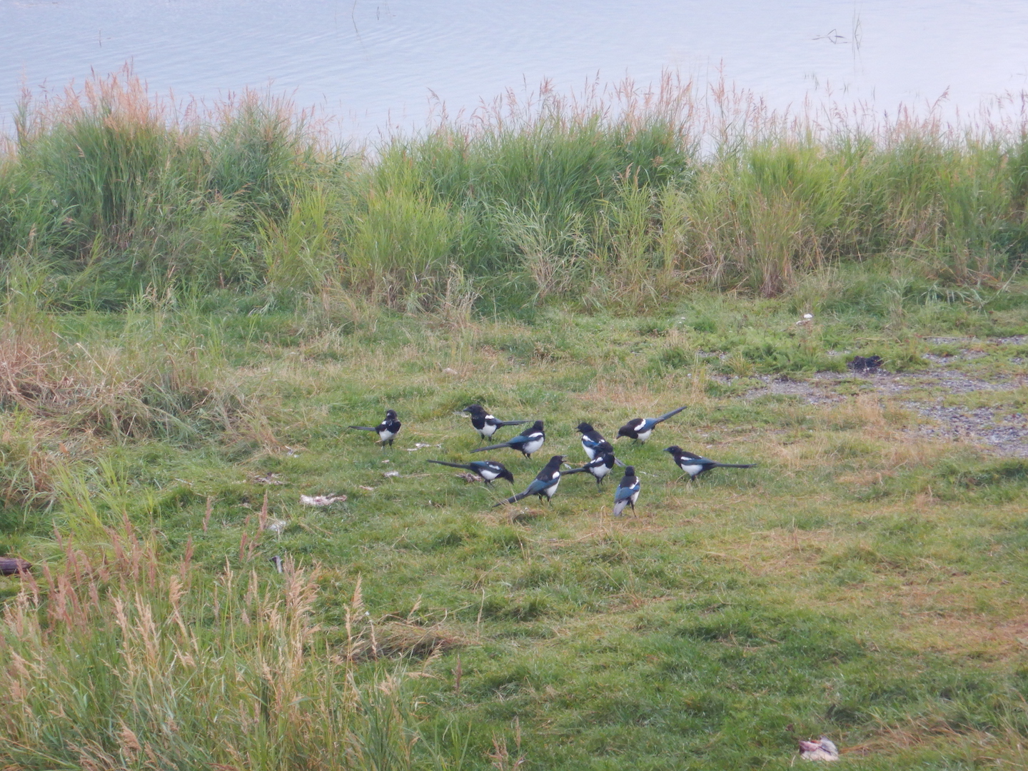
Magpie convention
With my time at Brooks Camp running low, I ventured to the falls for one last look at the largest of the river’s bears. 32 Chunk, 151, 474, 480 Otis, and 747 round out the adult male roster this morning. When 747 sees 474 walk upriver, 747 directly approached 474. Both of the palindromic-numbered bears began to cowboy walk and mark trees, 474 on the shore near the platform and 747 on the island downstream of the falls. When 474 moved behind the platform, likely as a subtle move to avoid 747, the larger 747 marked the same tree and urinated in the same places as 474. Out of the water, 747’s true size is revealed. He’s a giant of a bear, far fatter and larger than any other on the river.
Before I left the falls for the final time (this year at least), I watched a young subadult bear fish the lip. She appeared well practiced in this spot. Bears rarely fish the lip of the falls in late summer, a time when nearly all salmon have reached their spawning site and lack the energy reserves or motivation to surmount the falls. The abundance of silver salmon in the river this year, however, allowed her to exploit this fishing spot during a time when it usually wouldn’t be worth visiting.
This young subadult has fished the lip of Brooks Falls often recently. While bearcam viewers have speculated she might be one of 402’s emancipated cubs, this bear looked too big for a 2.5 year-old.
I encountered no significant delays on my return to the lodge to check in for my flight out. Lots of bears milled around the lower river, but I remained on the beach in front of the lodge to sit and watch 435 Holly and her cubs rest nearby.
435 Holly and spring cubs
Brooks River is a special place, unique among national parks, and I felt fortunate to spend time there once again even if the visit was too short.
When you enjoy watching wildlife as much as me, you don’t want to waste time with biological tasks like sleeping. Still, sleep is a necessity and I can’t watch bears in the dark. After a reasonably restful night, I woke before sunrise and left the campground when there was just enough light for me to see without a headlamp or flashlight. This would be my last full day at Brooks River in 2017 and intended to make the most of it.
Early morning hours at Brooks River are generally quiet. Planes haven’t arrived and most people are either sleeping or focused on breakfast. The dominant sound at this hour tends to be the cry of glaucous-winged gulls.
Bears like early morning meals just as much as people, and I fully expected to find bears too close to the trail or bridge for me to reach the relative safety of the lower river wildlife viewing platform. Luckily, the corridor from the lodge to the bridge and the platform was clear before 7 a.m. In a short while, however, bears filled the void and for much of the rest of the day the bridge would remain closed to people.
When I first reached the platform, only 409 Beadnose and her yearlings were visible. Her cubs behaved quite independently, catching most of their own salmon. Yet they remained prone to begging food from their mother and bawling when they want to nurse. Two subadults entered the river upstream of the platform. 410 made the most of her chance for breakfast, eating at least five salmon carcasses in a half hour. It was still too dark for my point-and-shoot camera to take clear photos, so I sat back, watched, and took notes.
409, her cubs, and two young subadult bears all eventually wandered toward the river mouth and the beach in front of the lodge, allowing more people to cross the bridge. As the platform got noisier, I decided it’s a good time to wander to Brooks Falls.
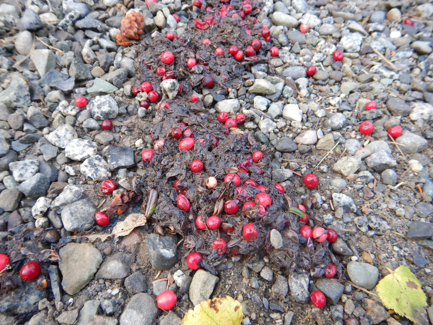
The walk to the falls is quiet and uneventful, but bears used the trail just moments before. Foam clung to the surface of a large puddle of urine and bright red, relatively undigested lingonberries polka dot the surface of a fresh pile of scat.
Even with the high abundance of salmon, bears were still feeding on berries.
The falls platform was empty when I arrived and no one else arrived for the next hour as bears remained too close to the bridge for people to cross. Within my experience at Brooks Camp, it’s rare to have the falls platform to yourself when bears are around.
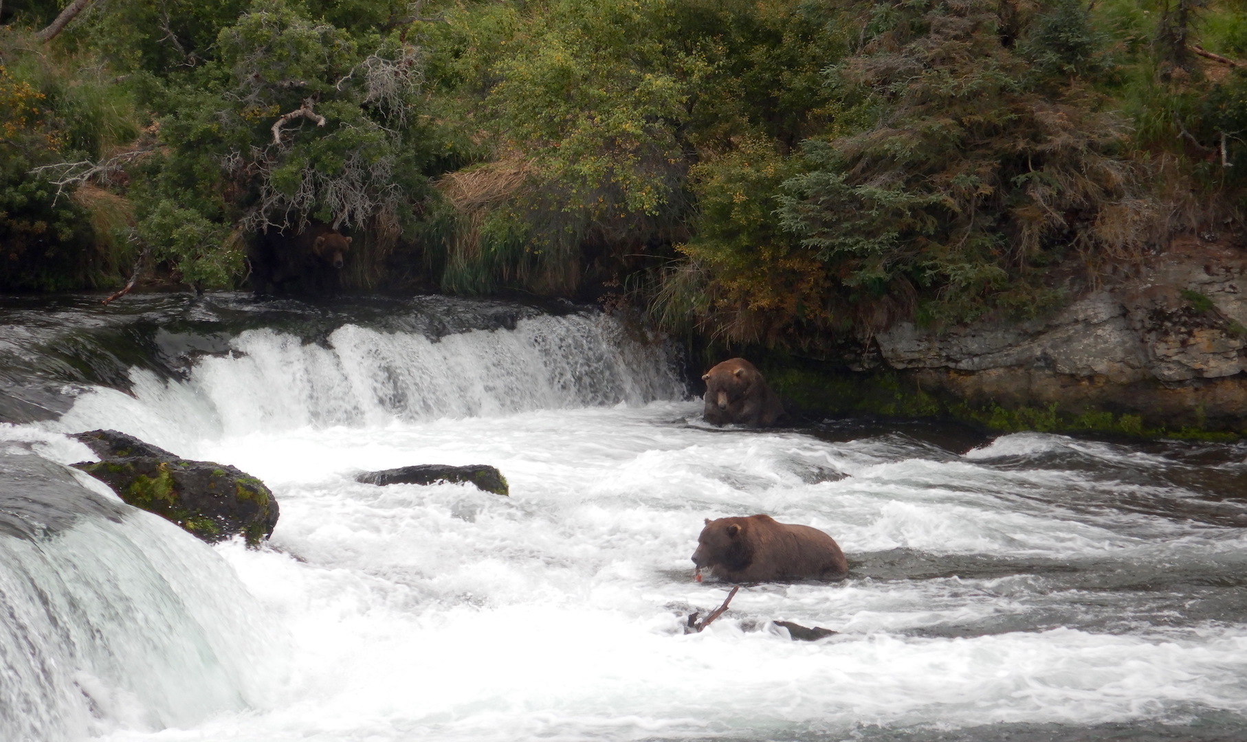
I quickly forgot about being alone though as bears were quite active. 410 had made her way from the lower river to the falls where she fished her normal spot in the far pool. 68 was giving it a shot in the jacuzzi. Both bears ignored each other and remained separated by about 30 yards. When 747 arrived 68 quickly moves out of the jacuzzi to make way for the larger bear.
After 747 decided to push the other bears around, 503 appeared in the far pool. While 747 is absolutely the largest bear at Brooks River, I was shocked at 503’s size. He’s not particularly fat, but’s he’s very big for his age. Bears grow quickly yet I don’t recall ever seeing a 4.5 year-old brown bear as big as 503.
Returning to the lower river, I watched more subadult antics. Now after 10 a.m., the bridge had not yet opened because bears were consistently within 50 yards of it. Four to five subadult bears, all of which I saw the previous day, fished and played nearby.
409 Beadnose and her yearlings wandered toward the bridge from the lake to rest.
Around 11:30 a.m., I contemplated crossing the bridge to eat lunch. At Brooks Camp food can only be eaten inside of buildings or at designated picnic areas. Possession of food, unless actively transporting it from one designated area to another, is also prohibited. With lots of bears in sight, I reasoned I could ignore my hunger pangs and eat later.
Upstream, 854 Divot and her yearlings scavenged for fish. Not yet having the opportunity to observe them much on this trip, I waited for them to fish their way downstream. Fall bears have a pattern though; they fish then sleep. Many human-habituated bears—especially 854 Divot, 409 Beadnose, 410, and 435 Holly—often choose to sleep near the trail between the lodge and the river. When that happens, the trail is usually closed until the bears wake and move on. I knew I risked a long delay getting to and fro if Divot and her cubs chose to sleep near the bridge or trail.
Which they did. At 12:10 p.m., Divot and cubs settled in for a nap on the bank just upstream of the floating bridge. With no alternative route around the bears, the bridge and trail were closed. There was nothing to do but wait. Bridge closures and Brooks Camp’s famous bear jams can be frustrating situations for people unaccustomed to them or too impatient for them, but bears need the habitat near the mouth of the river as much as they need the falls. To make a long story short (one I hope to tell in greater detail in the future) 854 slept in that spot for two hours and with many other bears fishing in the river, the bridge didn’t open for over three hours.
A half hour after crossing the bridge though and refreshed after a quick snack, I was back at the river when word of Otis’s arrival at Brooks Falls spread among the staff. Not knowing if I’d get another chance to see him before leaving the next day, I skipped bear viewing at the lower river to go to the falls, where I found 480 Otis as well as 68, 503, 719, 747, and an unidentified subadult.
480 fishes in his office at Brooks Falls shortly after arriving. 747 sits in the water nearby.
Rain moved through later in the evening, but I still had one more morning of bear watching to enjoy before my flight out.
Due to strong winds, I was unable to reach Brooks Camp on time. The next morning, as instructed by Katmai Air, I arrived at their dock before 7 a.m. I was eager to get on the “first load.” Evidently everyone who didn’t reach Brooks Camp the previous day was told they’d be on the “first load,” which caused Katmai Air to deal with some cranky customers. (Not me, I might add, but I understood others’ frustration.)
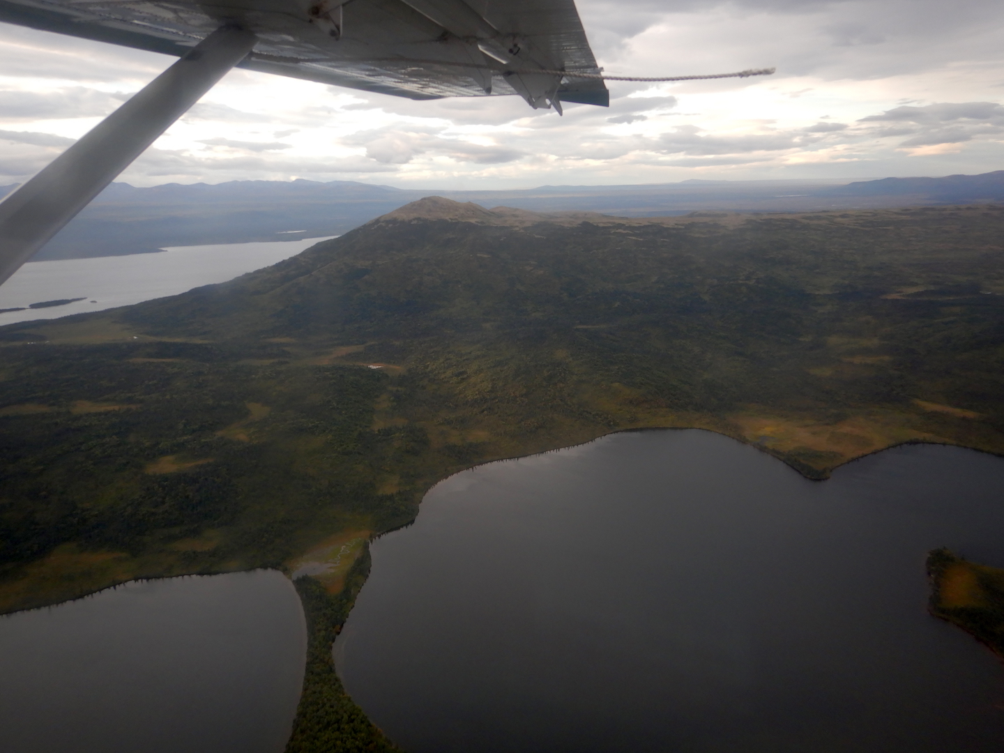
Looking southwest toward Mount Brooks from the air.
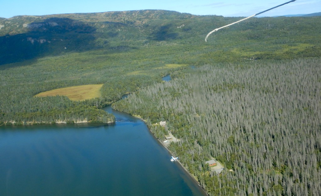
Around 8:40 a.m., I arrived at Brooks Camp—or Lake Brooks to be exact. Winds out of the east were still too strong for planes to land on Naknek Lake, but I didn’t mind the view of Dumpling Mountain and the head of Brooks River.
Dumpling Mountain and the outlet of Lake Brooks
After heading straight to the visitor center to get my bear orientation…
Yes, even former rangers are required to attend the bear safety talk upon arrival at Brooks Camp.
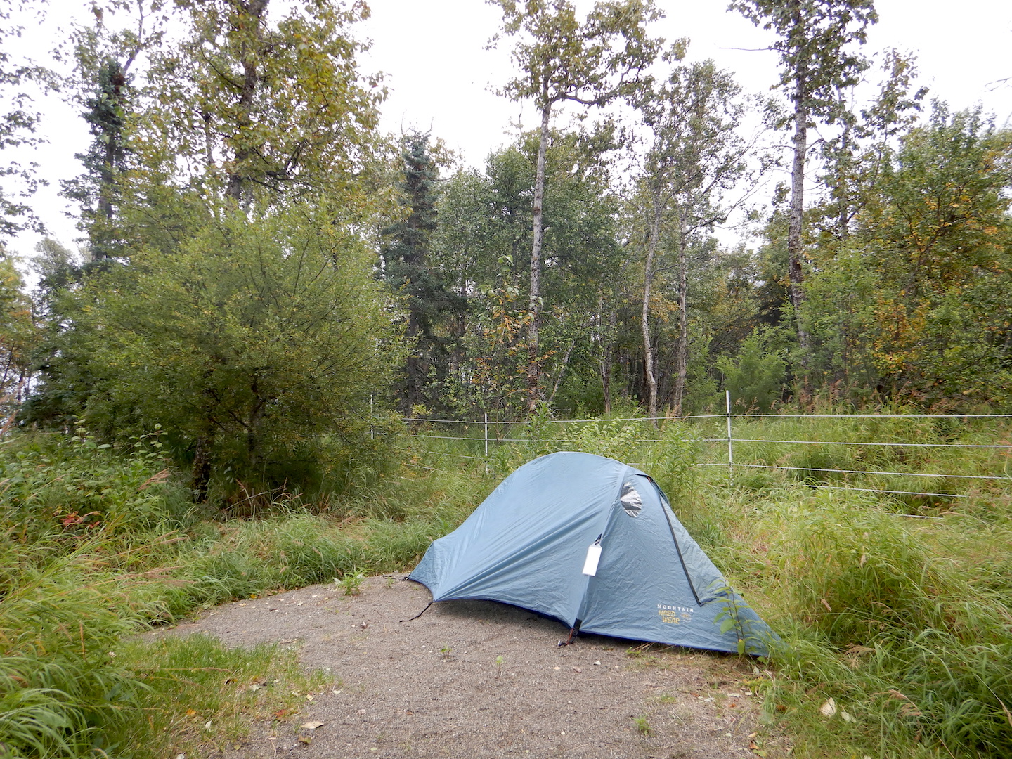
…I hurriedly pitched my tent in the campground….
My tent in the far southwest corner of the campground, as far away from other people as I could get.
…and walked back to the lower river to binge watch bears.
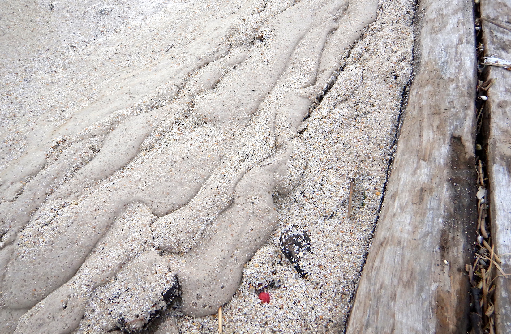
Fine pumice sand, evidence of the powerful winds from the previous day’s storm, was all over the beach.
In September, the wildlife-viewing platform near the mouth of Brooks River is my favorite place to be. Upstream, just where the river enters my line of sight from the platform, thousands of salmon work to complete their life cycle. As the fish weaken and die, the river’s current sweeps them downstream. Where the river’s current is not longer strong enough to carry them further, it drops the barely live and dead fish, making the river mouth and meanders just upstream the most productive salmon scavenging areas at Brooks.
When I arrive on the platform four subadult bears play and fish, while 409 Beadnose and cubs lounge nearby. After another large salmon run, the bears at Brooks River are well fed, and perhaps as a result the younger bears were especially playful.
One light brown subadult bear out of this bunch very much resembles 273’s yearling in 2016. This bear appears to be a young subadult, but is large for a 2.5 year-old.
Around noon, after Beadnose and cubs settled into a nap below the platform, I decided to visit Brooks Falls, where bears had been fishing in higher than average numbers for this time of year. I had a hypothesis as to why, but I needed at least a few cursory observations to support it.
Over my short stay, the vast majority of fish I saw bears catch at the falls were silver (coho) salmon. This run begins in August and often continues through September. Larger on average than sockeye, a single, fresh silver salmon can provide several thousand calories for bears skilled enough to catch them. Like the beginning of the sockeye run in late June and July, the late run of silver salmon is most accessible to bears at Brooks Falls.
Two adult male bears, 68 (left) and 879, fish the far pool of Brooks Falls.
But bears in the lower river make huge energy profits as well. In the early evening, after skipping a true lunch to eat an early dinner (to maximize bear watching time), I return to the lower river until sunset. 410 and 409 Beadnose both patrol the river slowly, snorkeling for any salmon that can swim away. In a half hour, 410 eats four fish. Over an hour, Beadnose leisurely consumes eight. These are relatively low catch rates for this section of river, yet even assuming the salmon carcasses provide less than half the energy they did in July (spawned out fish may contain 2000-2500 calories or less compared to the 4500 calories when the first arrived) 410 and 409 still ate at least 8,000 and 16,000 calories respectively. In past years, when 410 has remained within my line of sight longer at the lower river, I’ve counted her eating 41 fish in 3 hours 25 minutes. Even if she only ate part of each fish, when your profit is measured in calories needed to survive winter hibernation, this isn’t a bad day’s work.
As the sun begins to set behind the western toe of Dumpling Mountain, I relaxed to watch bears come and go from the river—128 Grazer, 409 Beadnose, 284, 410, 708, 610, four unidentified subadults, 879, 474, and many cubs. If the sun didn’t set so soon and I didn’t risk running a gauntlet of bears in the dark to get to the campground, I would’ve remained out for much longer. Responsible bear watching, however, includes not wandering around in the dark, so I retire to the campground eager for sunrise and another day on the river.
Late last July, after watching bearcam for a month, I got the itch to visit Brooks Camp where I had worked and lived for many summers. During an extended break from work recently, I spent a couple of nights camping there to binge watch bears. I had originally planned to spend three nights at Brooks Camp, but weather conditions conspired to alter my plans.
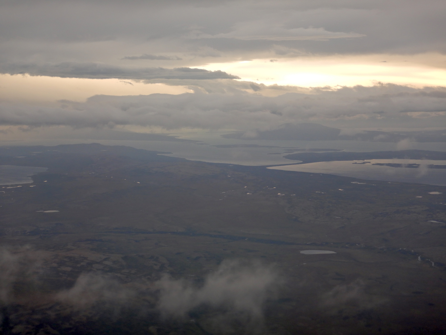
On September 3, during the final approach on my flight from Anchorage to King Salmon, I felt pangs of excitement and eagerness as I caught glimpses of Naknek Lake, Dumpling Mountain and much of the rest of western Katmai National Park.
Naknek Lake and Katmai National Park. (Pro tip: Never sit in row two on PenAir’s Saab 2000 airplanes as there is no window. I usually try to sit in rows 3-4 and 14-16 for the most unobstructed views of the landscape. To see Katmai, weather permitting, on flights from Anchorage to King Salmon sit on the left side of the plane.)
I arrived in King Salmon to mostly cloudy skies and a strong northeasterly wind. Situated at the head of the Alaska Peninsula, King Salmon and Katmai National Park often experience windy conditions, so I didn’t think much of it.
After checking in with Katmai Air, I patiently waited to board one of their small floatplanes, which would take me the final thirty miles to Brooks Camp. The wind increased in strength as I waited for my flight. Travelling via plane, rail, or bus usually stimulates mild anxiety in me, not because I fear a crash but because I don’t want to deal with delays. After the first Katmai Air flight left, I sat patiently for the plane to return so I could head to Brooks Camp. As it turned out, I would have to wait for nearly 24 more hours.
About 45 minutes after it left, the Katmai Air Otter returned with the same passengers. When I saw them exit the plane, I knew the chances of reaching Brooks Camp were slim that day.
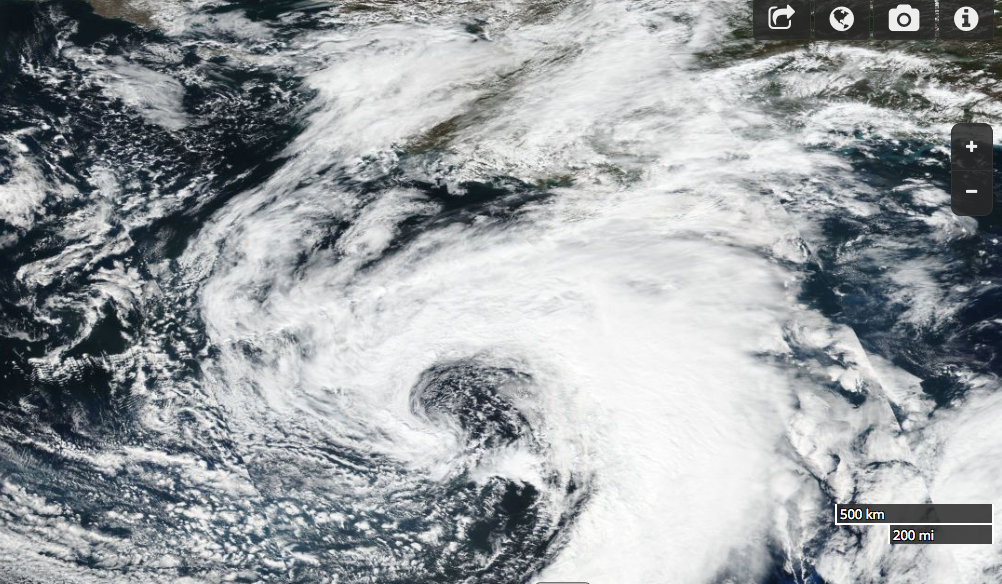
A strong low pressure system centered over Kodiak Island brought gale force winds to the northern Alaska Peninsula on September 3, 2017.
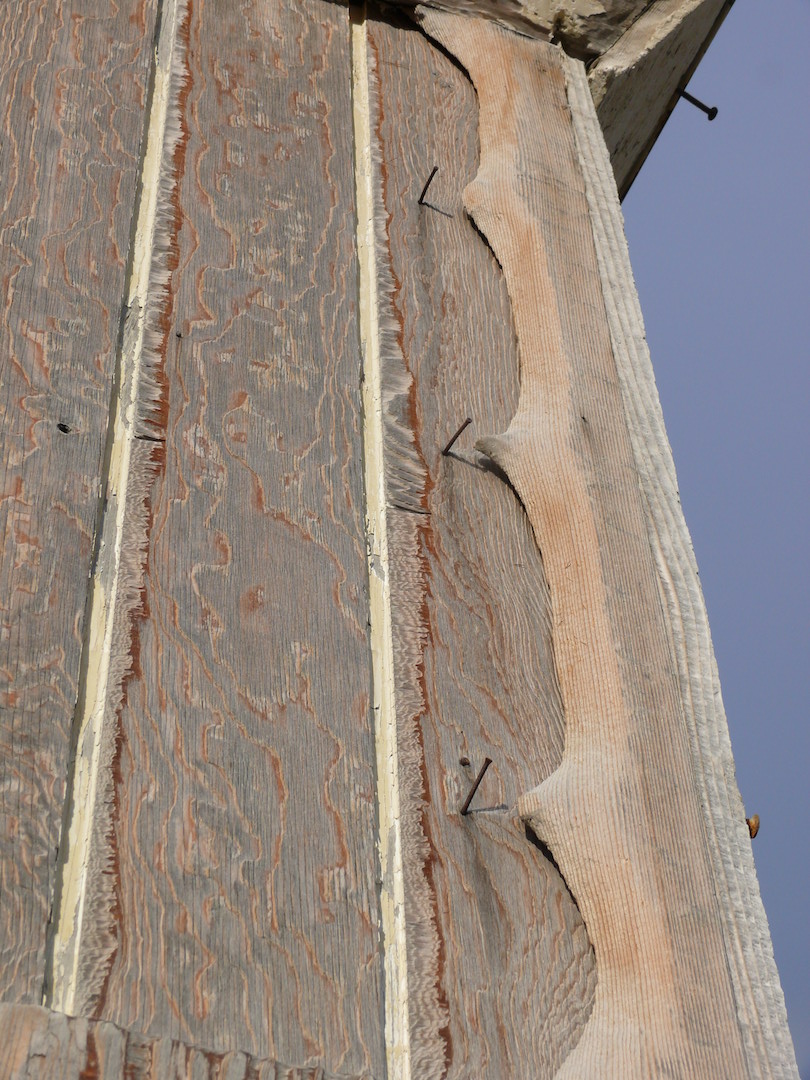
Katmai lies at the head of the Alaska Peninsula, a northeast-southwest trending arc of land jutting into the North Pacific. The peninsula’s location and orientation expose it to the vast majority of storms bred from the Aleutian Low, a semi-permanent low-pressure system originating near the outer Aleutian Islands. The peninsula’s mountains represent a major topographical barrier to these northeast-tracking storms. When winds funnel through mountain valleys along the Aleutian Range, they often come with great force. Through Katmai Pass, winds are strong enough to hurl large pieces of pumice through the air, scouring the upper Valley of Ten Thousand Smokes. (In Chapter XVII of The Valley of Ten Thousand Smokes, Robert Griggs describes weathering a violent wind storm that destroyed his camp near Katmai Pass in 1919.)
Nails on the Baked Mountain Huts in the Valley of Ten Thousand Smokes are one of the few things on the building that can withstand abrasive, wind-driven pumice.]
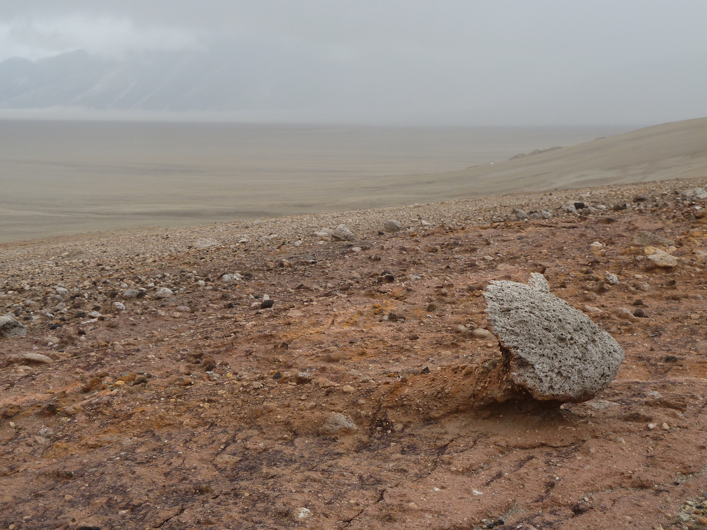
Rocks near Katmai Pass show signs of abrasion from blowing pumice. The strongest winds through the pass blow from south to north (right to left in the photo).
Although Brooks Camp and Brooks River lie at a much lower elevation than Katmai Pass, the area remains exposed to easterly winds driven through the Iliuk Arm of Naknek Lake. On my travel day, while conditions were never too windy to keep planes grounded in King Salmon, Brooks Camp was experiencing a gale.
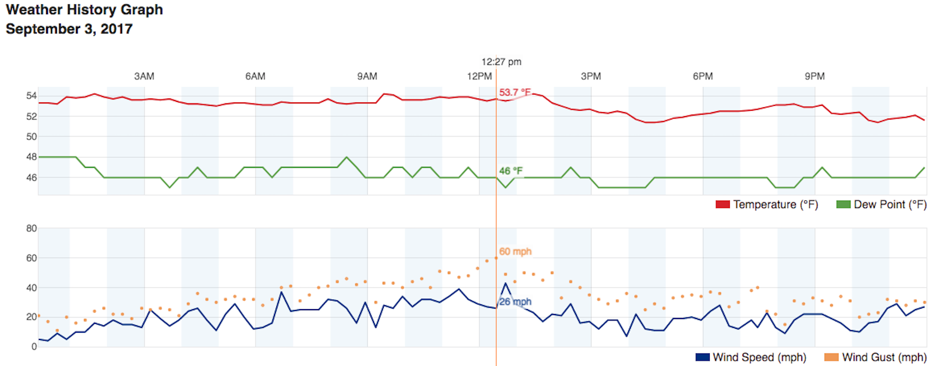
On September 3, 2017, the highest wind gust recorded at Brooks Camp was 60 miles per hour (97 kph) at 12:27 p.m.
Around noon, two hours after I was supposed to reach Brooks Camp, Katmai Air cancelled all day trips to Brooks River due to unsafe landing conditions and a lack of time. The faces of those on day trips expressed genuine disappointment. They left dejected. Knowing just how amazing Brooks River is, I don’t blame them. I felt my own bit of disappointment through the afternoon and evening. I would not reach Brooks Camp that day.
I had two more nights planned, thankfully, so I could wait out the storm and reach Brooks Camp (I’ll chronicle my experience there in forthcoming post). While flights to and from Brooks Camp are occasionally delayed, it’s rare for them to be canceled due to weather. Every few years though, a strong windstorm prevents safe landings and departures on Naknek Lake and Lake Brooks. In 2009, 60 people, who had only planned to spend one day at Brooks Camp, were stranded due to strong winds. No one who knows the area well would ever say the weather there is benign.