Origin stories seem to be almost requisite for superhero movies, even for well-known characters. (Like, we all know by now that a radioactive spider bit Peter Parker and Bruce Wayne witnessed the murder of his parents; so perhaps the next time Hollywood decides to reboot their tales, maybe just skip over those parts?) Landscapes, on the other hand? Their origins are not investigated nearly enough.
In my last post, I introduced the glacial origins of Brooks River, perhaps the most iconic wildlife viewing site in U.S. national parks. This was far from the full story though. After glaciers sculpted the land, a series of dramatic changes occurred as the river evolved into its current form. In this online chapter of The Bears of Brooks Falls: Wildlife and Survival on Alaska’s Brooks River, I investigate the river’s most recent origins. Brooks River is a superhero of a landscape, providing a home for bears, salmon, and people for thousands of years.
In the coming weeks, please check my blog and Twitter feed to find details about how to order signed copies of The Bears of Brooks Falls. And, be sure to ask for it at your favorite independent bookstore. The book ships out March 9, 2021.
Qit’rwik
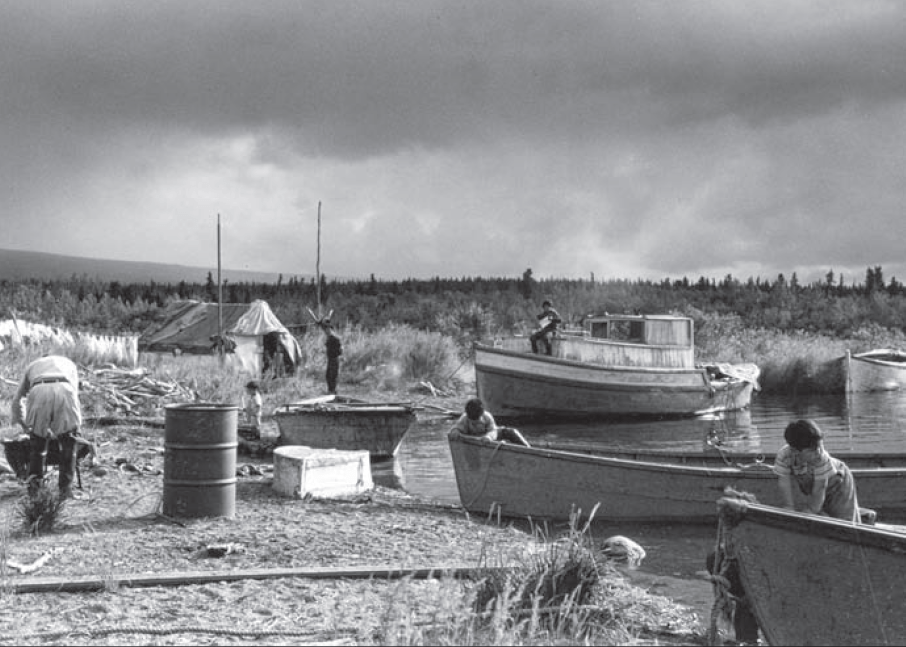
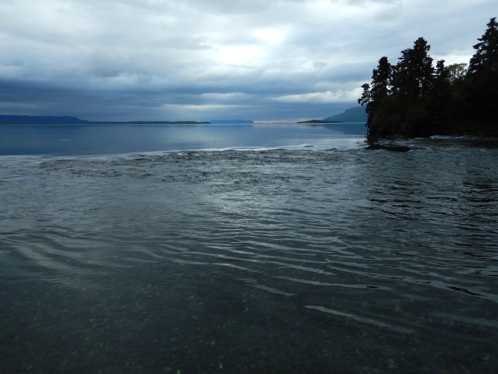
Throughout the years I spent as a ranger at Brooks Camp, I enjoyed exploring the thin ribbon of beach bordering Naknek Lake, especially in spring when the lake was near its annual low point. The beach stretching north from the mouth of Brooks River is one of the most inviting and extensive on Naknek Lake. It’s also temporary—a symbol of the lake and river’s continued evolution.
On a prime May evening in 2015, I make time to explore the changes wrought on the beach by the prior winter’s wind and waves. I exit the line of alder and spruce near the visitor center and walk toward a lake that is dramatically lower than the previous fall. Two wrack lines, built with airy pumice and driftwood flotsam, identify former high water stands from years past. The uppermost borders the very edge of the vegetation line and marked the high water mark in 2012, a year when the lake, or at least its wind-driven waves, rose to the beach’s upper boundary. The other, where the lake reached its maximum volume in 2014, is more than 10 feet closer to the water and a foot lower in elevation. Even with my eyes closed, when walking to the water from the tree line I could find the wrack lines by sound and texture. Pumice and small branches of driftwood roll and crunch underfoot like broken pieces of hard styrofoam. Gravel and sand, in contrast, feel heavy and less hollow.

When my feet reach the water’s edge, I turn right and walk south, approaching the river by paralleling a set of early season bear prints. I stop and face the river where it flows through a narrow channel barely a stone’s throw wide. I’m isolated at the end of a gravel bar, where the river finally meets the lake, and unable to go farther without wet feet. Otter tracks crisscross the sand, while on the opposite shore terns, mergansers, and gulls rest and preen on a bar of pebbles jutting into the shallow lake. They keep a wary eye on me but make no move to fly.
The beach and the gravel bars adjacent to the river mouth are altered by Naknek Lake’s predictable cycle of swelling and shrinking. It is widest in early spring after months of sub-freezing temperatures reduce the lake’s inflow to a trickle, and thinnest in early fall after a summer’s worth of rain, snowmelt, and glacial runoff fill the basin. In late summer, I couldn’t come close to approaching this area without swimming. I stand on dry ground about six feet lower in elevation than last autumn’s wrack line. A multi-year time lapse of this spot would record an annual cycle—the lake swelling with onset of spring thaw and shrinking when widespread freezing temperatures return in autumn. When flooded this spot is patrolled most often by hungry bears who swim in search of carcasses of spawned-out salmon.
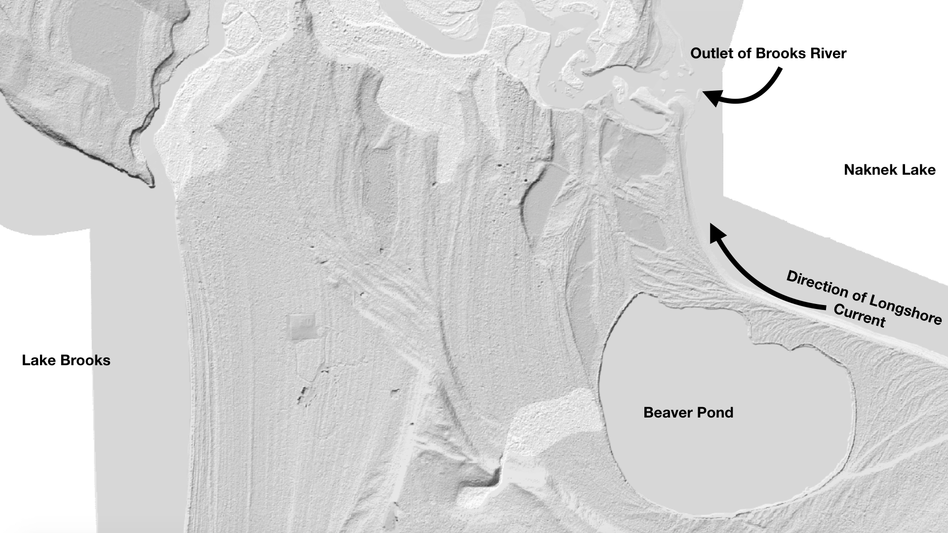
Wind-driven waves periodically reorganize the beach and river mouth. Temporary longshore currents, driven by strong easterly winds, purge sediments from the lakeshore south of the river and carry them northward. Storms shoal the unconsolidated sand and gravel into bars and spits, altering the flow of the river where it meets the lake.
Although these changes can be dramatic, the winter of 2014-2015 brought only a subtle reorganization to the river mouth. More sediment was deposited on a gravel bar near the tree line neighboring the lodge. On the south side of the river, a substantial spit grew a few feet northward. This spit arcs upstream into the river to create a calm, protected cove where waves do not reach, a convenient place for Brooks Lodge and National Park Service staff to moor boats away from the lake’s waves. I wondered how far this fan of gravel might one day extend. It’s grown a little wider every year of my observations.
An iteration of the spit and sheltered lagoon behind it has featured prominently at the river for hundreds of years, perhaps longer. In the Alutiiq (Supiaq) language, Brooks River is known as Qit’rwik. Pronounced kettiwick or kittiwick, Qit’rwik is a descriptive word that translates to a “sheltered place on the water.” More generically, a qit’rwik can refer to any lagoon or protected bay that is connected to open water and can provide shelter for a boat.
In September 1940, Mount McKinley National Park Superintendent Frank Been and U.S. Biological Survey biologist Victor Cahalane visited Katmai National Monument. They witnessed Alaska Natives, who traveled from the King Salmon and Naknek area to Brooks River, harvesting salmon. Mary Jane Neilson participated in those harvests and later recalled, “While we were at Qitirwik…Grandma…and our parents would catch fish to split and dry. The men built racks to dry the fish at the mouth of Brooks River on the south shore. Fish racks were still up in the 1950s when the National Park Service became more visible in the area.” Motorboats had replaced traditional mammal skin kayaks by then, but the river mouth, partly sheltered and enclosed by spits of sand and gravel, still provided people a safe harbor from wind-driven waves and a convenient spot to prepare and dry salmon.
Many a qit’rwik’s story is locked in place by fickle, shifting sediments and the evolving nature of Katmai’s lakes. South of the river mouth a small pond hides in the forest. Before the National Park Service constructed a one-lane road to it in 2014, I occasionally visited the Beaver Pond to escape Brooks Camp’s bustle or simply for a change of scenery. Walking south along the lakeshore from the river mouth, a hedgerow of alder, birch, and poplar trees obscured the pond and any resting bears in the vegetation, but the actual bushwhack to it was short when I chose the route correctly.
At first glance the pond is like many others in the area. It is moderately sized and oblong, measuring about 2000 feet east to west and 1600 feet north to south. Beavers, as its nickname suggests, have used it for decades although the pond is not a product of beaver industry. There is no dam to hold its water back nor does much flowing water enter it. The pond is fed primarily by rain, snow, and slow seepage from adjacent marshes.
Perhaps thousands of similarly-sized ponds dot western Katmai and the adjacent Bristol Bay lowlands, most of which are glacial kettle holes, features that form where stranded blocks of glacial ice were surrounded by till and outwash. As the isolated ice melted, they created enclosed basins that filled with water. Despite its superficial resemblance, Beaver Pond is not a kettle either. Its history began in the shifting sands and pebbles along the Naknek Lake shoreline.
The Beaver Pond occupies an open embayment that was once cleaved into the glacial outwash bordering Naknek Lake. At first, it may have been exposed to the full force of wind and waves, not unlike the modern-day beach adjacent to the lodge and visitor center. Strong winds funneling across the Aleutian Range and down Iliuk Arm did not permit the bay to remain open indefinitely, however. Wind stirred waves pushed gravel and sand westward from the raw, highly erodible glacial sediments near the Iliuk moraine. These collected into an overlapping series of northward-growing horsetail shaped spits. Eventually, the bay was encircled and permanently separated from Naknek Lake as the spits migrated and thickened toward Brooks River. The Beaver Pond’s divorce from Naknek Lake may have taken decades or centuries, to finalize. All the while, the growing horsetail-shaped spits created a series of long-lasting qit’rwiks.
The Beaver Pond’s formation is just a small part of a more ancient story, one that explains how Brooks River evolved and how it became an important place for people.
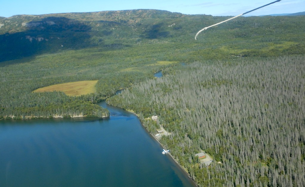
Brooks Lodge and the NPS visitor center sit on a lumpy terrace about 12 feet higher than the highest historical stands of Naknek Lake. From the lodge, the terrace’s geometry is apparent. Shaped by waves on one side while the river carved into the opposite shore, it tapers wedge-like toward the river mouth. This is just one of the many old terraces undulating throughout the river corridor from the Beaver Pond to Dumpling Mountain and upstream to Lake Brooks. At first glance, especially when bushwhacking in the forest’s dim confines, the terraces seem haphazardly placed, but a closer look reveals a roughly concentric shape to many. Between the river mouth and Lake Brooks, their concave faces open toward Naknek Lake and climb in a stair step manner—a series of short, steep rises each topped with a relatively flat bench. The terraces continue dozens of feet up nearby hillsides.
When the large Ice Age glaciers vacated Katmai, a series of glacial lakes began to occupy the excavated basins. Such lakes are far from static and often subject to rapid change, filling quickly and sometimes draining even quicker. Those in Katmai rose far above the modern counterparts; their waters held back by temporary ice dams or raw, erodible, and sparsely vegetated terminal moraines.
Lake Brooks was perhaps the first lake in the Brooks River area to undergo a rapid transformation. At the greatest extent of the Newhalen stade glaciers, 23,000 to 20,000 years ago, ice filled two-thirds or more of Naknek Lake’s basin, extending lobes around the north and south sides of Dumpling Mountain. The southernmost lobe pushed completely across the area now covered by Lake Brooks. When this glaciation waned, Lake Brooks began to fill the void. Unlike today, though, when Lake Brooks feeds Brooks River and Naknek Lake, this first iteration of Lake Brooks didn’t find connectivity with an infant Naknek Lake. It was walled in by ice to the east, mountains to the north and south, and a newly deposited terminal moraine to the west. Ancestral Lake Brooks had nowhere to go but up.
Evidence for its rise is preserved in wave cut terraces that lie stranded on hillsides. The highest such terrace sits near the western end of Lake Brooks. At more than 200 feet in elevation, it is 140 feet above the lake’s modern level. At its greatest height, liquid water likely occupied only the far western end of the Lake Brooks basin and only for a short period of time. Filled to capacity and separated from the Naknek Lake basin by ice, Lake Brooks spilled over the moraine on its western shore and drained west through the Bristol Bay lowlands. At the same time, a proto-Naknek Lake began to form in front of the glacial lobe north of Dumpling.
The ice divide between the lakes was short lived and the lakes merged after the Newhalen-aged glacier receded sufficiently to release Lake Brooks’ water into the Naknek basin. With the ice divide gone, Naknek Lake captured and reversed the flow of Lake Brooks.
Naknek Lake now covers 150,000 acres and is the largest lake wholly contained within a U.S. national park. Six large lakes (Brooks, Coville, Grosvenor, Hammersley, Idavain, and Murray), Savonoski River, Ukak River, and countless small ponds and creeks feed it. Yet Naknek Lake is a shell of its former self. It changed just as dramatically as Lake Brooks, if not more so, although these changes are far from finished.
Naknek Lake currently sits at a modest 42 feet in elevation, but in the wake of glacial retreat, the Pike Ridge moraine at the lake’s west end was a formidable barrier to water. Before any outlet could drain the lake, water had to rise high enough to overtop this earthen dam. It did only after reaching heights not seen before or since. Wave cut terraces and stranded beaches adjacent to the lake exist at 190 feet above sea level in the uplands adjacent to the lake. At full pool, Naknek Lake was as much as a third larger than today. It swallowed half of the Savonoski River floodplain; annexed Lake Brooks (el. 72 feet), Lake Coville (el. 108 feet), and Lake Grosvenor (el. 108 feet); made islands out of Dumpling Mountain and Mount La Gorce; and drowned the future site of Brooks Falls underneath dozens of feet of frigid water. For thousands of years after glaciers left, the lake remained so high that no hint of Brooks River existed.
Slowly, Naknek River’s down cutting reduced the Naknek Lake’s storage capacity. Islands merged. Rivers lengthened. Lake basins separated. All the while, waves carved terraces onto mountainsides during prolonged pauses in the draining. But the future site of Brooks River remained an abyss. Terraces higher than 98 feet in elevation are capped with volcanic ash from an eruption twelve to thirteen thousand years ago, indicating the land adjacent to the modern river mouth was still below as much as 56 feet of glacially cold water at the time.
After Naknek Lake captured its water, the Lake Brooks basin mirrored the changes of greater Naknek Lake for thousands of years until they separated for good between 6,500 and 5,500 years ago. Then, lowering lake levels exposed a dike of igneous rock in the path of the water flowing from Lake Brooks to Naknek Lake. At the surface after thousands of years or subaqueous inconsequentiality, and unlike the veneer of unconsolidated glacial till and lake sediments covering much of the Brooks River area, this bedrock was not easily erodible. Meanwhile, Naknek Lake continued to drain away as its outlet, Naknek River, eroded through the terminal moraine serving as the lake’s dam. The gently lapping water of Lake Brooks lacked the erosive energy to remove its newfound bedrock dam, however. Lake Brooks, perhaps for the first time ever, became locked in place.
Nearly all the dry land surrounding Brooks River today was exposed when the first semblance of a river formed five thousand years ago, but water levels were still high enough that the early river was very short, merely a wide area of slowly flowing water between the diverging basins. Less of a river than a narrow strait, the area quickly became an important resource for animals and people.
The oldest evidence of people known from the Alaska Peninsula comes from a squeeze of land about 75 miles southwest of Brooks River. Ugashik Narrows separates north and south Ugashik Lakes on the Alaska Peninsula National Wildlife Refuge, and is one of the most popular sport fishing destinations in all of southwest Alaska. Evidently, its popularity extends much further back in time. Artifacts at the narrows reach 9,000 years in age, but the first people there may not have been fishing much. Chipped stone tools suggest the first residents at Ugashik Narrows came for caribou, animals that would’ve moved efficiently across the open, tundra-like habitat, browsing on lichens in winter and green forbs in the summer. Instead of swimming across the lakes at Ugashik, the caribou crossed the stream at the narrows. People let the land funnel their quarry.
A similar dynamic occurred at the Brooks River narrows circa 3000 BC. A caribou herd moving toward the river narrows faced a choice: swim across miles of open lake water or follow the land. Caribou are good swimmers, but like many terrestrial mammals they often stay high and dry when given the option. The first people at Brooks River, like those at Ugashik Narrows, knew this well. They followed the migratory herds to the emergent Brooks River or established camps there and waited. Archeological excavations uncovered large stone lances and knives—weapons used to hunt large mammals—from Brooks River’s earliest human inhabitants. Caribou bones within their campsites prove they were successful.
The currently available archeological evidence suggests, curiously, that salmon were not a major food source for the earliest cultures at Brooks River even though salmon may have colonized Katmai’s lakes soon after they formed. Analysis of sediment cores from Nonvianuk Lake north of Brooks River indicate the presence of anadromous salmon there as much as 10,000 years ago, but no direct evidence of this yet been obtained for Naknek Lake so far back in time. The placement of the earliest camps at Brooks River are away from what would have been the water’s edge at the time, so if salmon were present when the first people arrived, perhaps they weren’t abundant enough to target or the strait between the Lake Brooks and Naknek Lake basins was too challenging to fish successfully.
No matter the reason for the lack of piscivory, free passage for salmon through Brooks River was short lived. As Naknek Lake continued to recede, the strait evolved into a river. Approximately 4,000 years ago the lengthening river uncovered a ridge of sedimentary rock less than a mile downstream of Lake Brooks. At first, Naknek Lake remained high enough that barely a ripple tumbled over the hard conglomerate. Perhaps it was unnoticeable to the salmon migrating in the young river. The ripple grew year by year, growing taller as Naknek Lake withdrew. By 3,500 years ago a distinct plunge formed, one high enough to temporarily impede salmon migrating upstream to spawn. Brooks Falls had emerged.

I like to imagine a qit’rwik from long ago, a harbor that perhaps inspired the proper name, Qit’rwik. The former waterfront property hides today within the surrounding forest with artifacts from previous cultures buried in the thickening duff. That qit’rwik foreshadows the fate of Brooks Lodge, the rangers’ cabins, the campground, and the visitor center. Could the newly conceived gravel bars at the river mouth, which seem so ephemeral at first glance, become a future qit’rwik as the river continues to evolve? Some iteration of Brooks River and its adjacent lakes will remain long into the future. It won’t be the same, but it’s far more likely to outlast our cultures than we are to outlast it.
References:
- Brooks River known as Qit’rwik and meaning of word: Helen Lons email to Katmai National Park Staff. 2007.
- In September 1940, Mount McKinley National Park Superintendent Frank Been and U.S. Biological Survey biologist Victor Cahalane visited Katmai National Monument: Norris, Frank B. 1996. Isolated Paradise: An Administrative History of the Katmai and Aniakchak National Park Units. National Park Service. Pg. 60.
- Mary Jane Neilson quote: Neilson, M. J. 2005. The Pelagia Story. Unpublished Masters Thesis. University of Alaska Fairbanks. P. 43.
- Definition of kettle hole: Hambrey, M. and Jurg, A. 2004. Glaciers, 2nd Edition. Cambridge University Press.
- These collected into a series of lengthening beaches, which migrated and thickened toward Brooks River into horsetail shaped spits: Hults, C.P. 2016. Draft Geomorphic Map of the Brooks River Area and Part of the Road to Valley of Ten Thousand Smokes. Natural Resource Report NPS/NRSS/GRD/NRR-2016/. National Park Service, Alaska Regional Office, Anchorage, Alaska. LIDAR imagry of the Brooks River area clearly shows the land’s geomorphology and can be viewed at http://maps.dggs.alaska.gov/elevationdata/#-17339224:8083535:14.
- Age of Beaver Pond: The ages of the spits encircling Beaver Pond are not precisely known, but are most likely young. Some are perhaps fewer than three hundred years old. The elevation of sediments north of the pond is slightly higher than the modern day lake elevation (13 m). The sediments also lack pre-Russian contact archeological artifacts that would indicate an earlier origin.
- Lake Brooks spilled over the moraine on its western shore and drained directly on to the Bristol Bay lowlands: Ibid. Hults, C.P. 2016.
- Timeline of Lake Brooks/Naknek Lake separation and former elevation of lakes: I relied heavily on the elevations and summary in Hults, C.P. 2016. It is also explained in Dumond, D. E. 1981. Archeology on the Alaska Peninsula: The Naknek Region, 1960-1975. University of Oregon Anthropological Papers. No. 21.
- Naknek Lake was certainly lower in elevation than Lake Brooks, perhaps as low as present day: Ibid, Hults. 2016. After Naknek Lake captured Lake Brooks, one last push of ice formed the Iliuk moraine around 20,000 years ago. Discharge from this brief advance formed the broad spruce-covered outwash plain south of Brooks River. Braided drainage channels on its surface indicate the outwash plain was deposited on land, not under a lake, and terraces as high as 68 meters are conspicuously absent along Lake Brooks’ eastern shoreline.
- At full pool, Naknek Lake was as much as a third larger than today: This is my rough guess based on the minimum combined surface areas of Naknek, Brooks, Coville, and Grosvenor Lakes.
- Wave cut terraces at 59 and 57 meters above sea level, respectively, indicate the lake was once much higher and more extensive: Curiously, isostatic rebound is not believed to have significantly altered the elevation of the terraces. Kaufman, D. S., and K. B. Stillwell. 1995. “Preliminary Evaluation of Post Glacial Shorelines” in Geologic Studies in Alaska. Dumoulin and Gray, Editors. U.S. Geological Survey.
- All terraces higher than 30 meters in elevation are capped with volcanic ash from an eruption twelve to thirteen thousand years ago: Ibid, Kaufman and Stillwell. 1995.
- Artifacts at Ugashik Narrows are approximately 9,000 years old: Dumond, D. E. 1987. Prehistoric Human Occupation in Southwestern Alaska: A Study of Resource Distribution and Site Location. University of Oregon Anthropological Papers. No. 36.

Thank you, Mike, for sharing this very interesting history and geology of Naknek Lake and Katmai. There is always something new to learn about this magical place. Looking forward to reading your book.
LikeLiked by 1 person
I love the history of the area that I’ve grown so fond of just watching the cams. Thank you, Mike. It’s very well written and over the years I feel as though I know you somewhat after reading your articles and listening to presentations.Sent from my Verizon, Samsung Galaxy smartphone
LikeLiked by 1 person
So looking forward to your book Mike ! I learned so much from You and Jeanne and Ranger Roy back in the earlier days of 2012 – 2015. All I knew about bears when I began to watch the cams was that they were very dangerous animals. The Live Cams and talks were a great learning experience..
Thank You !
LikeLiked by 1 person
Well, well, you do happen to write “in a logical, intelligent, and engaging manner.” 😉 Good luck with the launch! (It’ll be great!) Paws crossed (and even eyes)!
LikeLike
Pingback: Q & A: The Bears of Brooks Falls Book Club | Wandering at Large