Life as a champ is rough. Rivals look to take advantage of any weakness you might show. Arm chair critics analyze your every move. Fans expect perfection. When the next championship tournament rolls into town your body has aged another year and your preferred food has worked its hardest to evade and escape you. Meanwhile, you’re trying to live your best life, because you are a bear and the concerns of humans matter not to you.
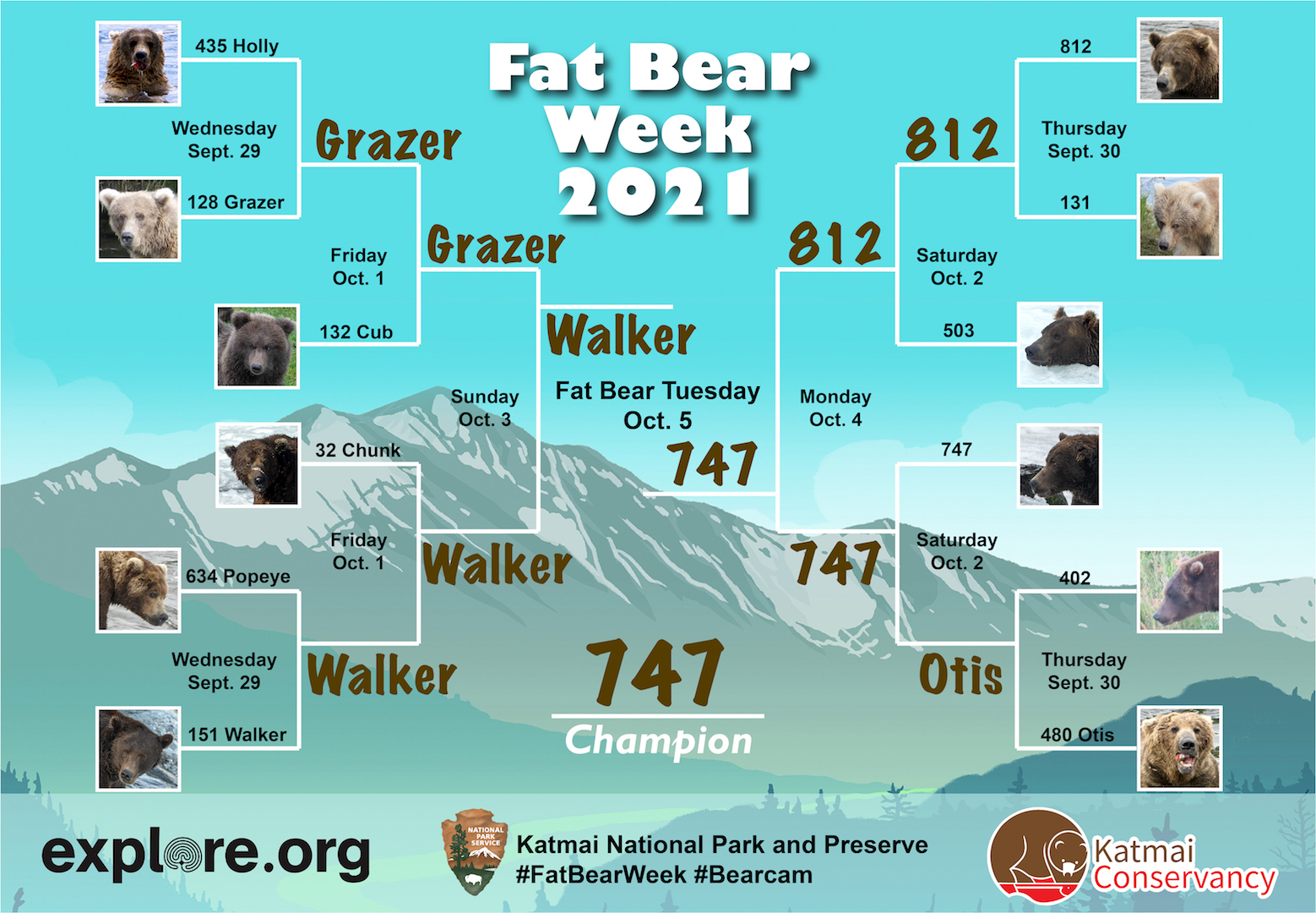
Yet, for those of us who recognize greatness and celebrate success when we see it, there is one clear choice for Fat Bear Week 2021—the mighty 747.
Long-time readers of this blog may be thinking, “This again?”
…Let me tell you dear friends: 747 is as fat as ever. He deserves your Fat Bear Week vote.
Brown bears get fat to survive. Their obesity (and it is that since a bear’s body fat percentage is routinely 20-30 percent or more when they begin hibernation) is a savings account. In the den, bears do not eat or drink. They stay warm and hydrated by burning body fat. Unlike utilizing muscle for energy—a process that produces metabolic wastes that must be recycled, sequestered, or purged from the body—burning fat is a relatively clean fuel as I write in chapter 4 of my book, The Bears of Brooks Falls.
It’s akin to cultivating mass only to carefully harvest it later. Just not for vanity’s sake, bro.
747 cultivates mass at an exceptional rate. This summer, he reigned as Brooks River’s most dominant adult male. Even the river’s long-time dominant bear, 856, would not challenge him, and as a result 747 had nearly free access to any fishing spot of his desire.
A single brown bear can eat thousands of pounds of salmon per year. The largest can eat 6,000 to 10,000 pounds. Given his size, appetite, high rank in the bear hierarchy, and his keen fishing skills, 747 is more than capable of eating many thousands of pounds of salmon each summer. At Brooks Falls, he intercepts a great deal of fish by being at the right place at the right time and waiting for his food to come to him. When Brooks River’s sockeye migrated upstream, 747 was primed to harvest them.
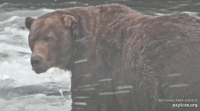
He’s so successful that in September 2019 and again in September 2020, he was estimated to weigh more than 1,400 pounds. This places him, as I estimate, among the top one percent of brown bears based on body mass.
Even with his size, he remains agile.
747 reminds Grazer and cubs that he's still a dominant big boy at Brooks Falls. pic.twitter.com/mNNNF3OD66
And yes, that is a tapeworm hanging on for a ride.
Fat Bear Week celebrates the success of Brooks River’s bears, the ecosystem and salmon that sustain them, and the bears’ abilities to get fat and survive. 747 exemplifies success among adult male brown bears. He deserves your vote and a repeat Fat Bear Week victory.
It’s been two months since my book, The Bears of Brooks Falls, was released for your reading pleasure. Whether you’re fortunate enough to visit Brooks River in person or if you are a fan of the Brooks River bearcams on explore.org, I hope the book will become a valuable companion to your bear-watching experience. I’ve been pleased to find many people have enjoyed it and found its storylines to be enlightening.
I also hope it’s provoked your curiosity about bears, salmon, Katmai National Park, the history of national parks, and the evolving role that people play in parks and other wild landscapes. With bearcam season right around the corner (expect the cams to go live in mid to late June), I’m also coordinating with bookstores to host online talks about the book.
There’s been no designated place for readers to ask questions about the book though, so let this post serve that purpose. If you have a question or a comment about something you read in The Bears of Brooks Falls, then please drop it in the comments. I’ll do my best to reply. And, of course, I’ll be online almost everyday during bearcam season to answer your questions about bears and salmon as the resident naturalist with explore.org.
Many years ago, inspired by the complicated and fascinating intersection of bears, salmon, and people at a most unique place, I conceived the idea of a book that captured the story of Brooks River in Katmai National Park.
Part one of The Bears of Brooks Falls explores the establishment of Katmai National Monument, from the moments preceding the largest volcanic eruption of the 20th century to the discovery of the surreal Valley of Ten Thousand Smokes. These events inspired the creation of Katmai National Monument and, soon after, the efforts to expand the park for wildlife like brown bears.
Today, Katmai is most famous for its brown bears. Part two is devoted to their lives as well as the salmon that the bears depend on for their survival. I explore the marvel of the hibernating bear, discover Brooks River from a cub’s perspective, and follow the tribulations and growth of young bears recently separated from their mother. I also ponder how Katmai’s brown bears experience reproduction, competition, hunger, and death.
Few organisms are as important to an ecosystem as sockeye salmon are to Brooks River. These fish face tremendous obstacles and challenges. From freshwater to the ocean and back again, they travel thousands of miles, running a gauntlet of predators to fulfill their destiny. The journey ends when they sacrifice their lives to reproduce. Salmon are Katmai’s keystone, driving Brooks River’s productivity and significance.
In part three, I examine modern humanity’s influence over Brooks River. Humans may be the river’s biggest wildcard. Climate change looms large over the land and seascapes, and people alter the behavior of the bears that make the scene so special. The infrastructure needed to support thousands of visitors and their recreational activities invites conflict with bears. Managing bears and people in such a small area is especially challenging, provoking a decades-long and often emotional debate about the river’s future.
Brooks River’s bears live in a land that straddles the border between the wild and human realms. Their lives are intertwined with ours, and as a result Brooks River is a microcosm for many of the issues facing our national parks. No book has captured this story before.
I’d also love to know what you think of the book. Drop a comment in response to this post, email me, or post a review on the websites of major booksellers.
Origin stories seem to be almost requisite for superhero movies, even for well-known characters. (Like, we all know by now that a radioactive spider bit Peter Parker and Bruce Wayne witnessed the murder of his parents; so perhaps the next time Hollywood decides to reboot their tales, maybe just skip over those parts?) Landscapes, on the other hand? Their origins are not investigated nearly enough.
In my last post, I introduced the glacial origins of Brooks River, perhaps the most iconic wildlife viewing site in U.S. national parks. This was far from the full story though. After glaciers sculpted the land, a series of dramatic changes occurred as the river evolved into its current form. In this online chapter of The Bears of Brooks Falls: Wildlife and Survival on Alaska’s Brooks River, I investigate the river’s most recent origins. Brooks River is a superhero of a landscape, providing a home for bears, salmon, and people for thousands of years.
In the coming weeks, please check my blog and Twitter feed to find details about how to order signed copies of The Bears of Brooks Falls. And, be sure to ask for it at your favorite independent bookstore. The book ships out March 9, 2021.
Qit’rwik
Throughout the years I spent as a ranger at Brooks Camp, I enjoyed exploring the thin ribbon of beach bordering Naknek Lake, especially in spring when the lake was near its annual low point. The beach stretching north from the mouth of Brooks River is one of the most inviting and extensive on Naknek Lake. It’s also temporary—a symbol of the lake and river’s continued evolution.
On a prime May evening in 2015, I make time to explore the changes wrought on the beach by the prior winter’s wind and waves. I exit the line of alder and spruce near the visitor center and walk toward a lake that is dramatically lower than the previous fall. Two wrack lines, built with airy pumice and driftwood flotsam, identify former high water stands from years past. The uppermost borders the very edge of the vegetation line and marked the high water mark in 2012, a year when the lake, or at least its wind-driven waves, rose to the beach’s upper boundary. The other, where the lake reached its maximum volume in 2014, is more than 10 feet closer to the water and a foot lower in elevation. Even with my eyes closed, when walking to the water from the tree line I could find the wrack lines by sound and texture. Pumice and small branches of driftwood roll and crunch underfoot like broken pieces of hard styrofoam. Gravel and sand, in contrast, feel heavy and less hollow.
The beach at Brooks Camp in springtime. Photo looks south toward the outlet of Brooks River.
When my feet reach the water’s edge, I turn right and walk south, approaching the river by paralleling a set of early season bear prints. I stop and face the river where it flows through a narrow channel barely a stone’s throw wide. I’m isolated at the end of a gravel bar, where the river finally meets the lake, and unable to go farther without wet feet. Otter tracks crisscross the sand, while on the opposite shore terns, mergansers, and gulls rest and preen on a bar of pebbles jutting into the shallow lake. They keep a wary eye on me but make no move to fly.
The beach and the gravel bars adjacent to the river mouth are altered by Naknek Lake’s predictable cycle of swelling and shrinking. It is widest in early spring after months of sub-freezing temperatures reduce the lake’s inflow to a trickle, and thinnest in early fall after a summer’s worth of rain, snowmelt, and glacial runoff fill the basin. In late summer, I couldn’t come close to approaching this area without swimming. I stand on dry ground about six feet lower in elevation than last autumn’s wrack line. A multi-year time lapse of this spot would record an annual cycle—the lake swelling with onset of spring thaw and shrinking when widespread freezing temperatures return in autumn. When flooded this spot is patrolled most often by hungry bears who swim in search of carcasses of spawned-out salmon.
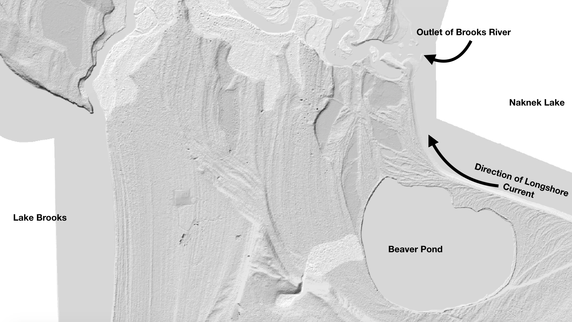
Wind-driven waves periodically reorganize the beach and river mouth. Temporary longshore currents, driven by strong easterly winds, purge sediments from the lakeshore south of the river and carry them northward. Storms shoal the unconsolidated sand and gravel into bars and spits, altering the flow of the river where it meets the lake.
Although these changes can be dramatic, the winter of 2014-2015 brought only a subtle reorganization to the river mouth. More sediment was deposited on a gravel bar near the tree line neighboring the lodge. On the south side of the river, a substantial spit grew a few feet northward. This spit arcs upstream into the river to create a calm, protected cove where waves do not reach, a convenient place for Brooks Lodge and National Park Service staff to moor boats away from the lake’s waves. I wondered how far this fan of gravel might one day extend. It’s grown a little wider every year of my observations.
An iteration of the spit and sheltered lagoon behind it has featured prominently at the river for hundreds of years, perhaps longer. In the Alutiiq (Supiaq) language, Brooks River is known as Qit’rwik. Pronounced kettiwick or kittiwick, Qit’rwik is a descriptive word that translates to a “sheltered place on the water.” More generically, a qit’rwik can refer to any lagoon or protected bay that is connected to open water and can provide shelter for a boat.
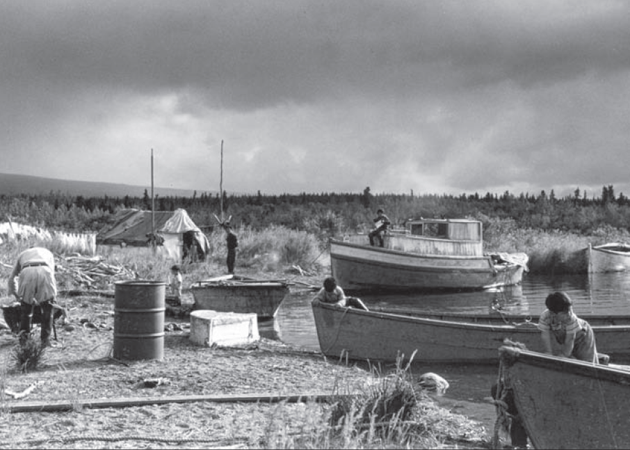
In September 1940, Mount McKinley National Park Superintendent Frank Been and U.S. Biological Survey biologist Victor Cahalane visited Katmai National Monument. They witnessed Alaska Natives, who traveled from the King Salmon and Naknek area to Brooks River, harvesting salmon. Mary Jane Neilson participated in those harvests and later recalled, “While we were at Qitirwik…Grandma…and our parents would catch fish to split and dry. The men built racks to dry the fish at the mouth of Brooks River on the south shore. Fish racks were still up in the 1950s when the National Park Service became more visible in the area.” Motorboats had replaced traditional mammal skin kayaks by then, but the river mouth, partly sheltered and enclosed by spits of sand and gravel, still provided people a safe harbor from wind-driven waves and a convenient spot to prepare and dry salmon.
The Melgenak and Angasan families at Qit’rwik in 1950. National Park Service Photo.
Many a qit’rwik’s story is locked in place by fickle, shifting sediments and the evolving nature of Katmai’s lakes. South of the river mouth a small pond hides in the forest. Before the National Park Service constructed a one-lane road to it in 2014, I occasionally visited the Beaver Pond to escape Brooks Camp’s bustle or simply for a change of scenery. Walking south along the lakeshore from the river mouth, a hedgerow of alder, birch, and poplar trees obscured the pond and any resting bears in the vegetation, but the actual bushwhack to it was short when I chose the route correctly.
At first glance the pond is like many others in the area. It is moderately sized and oblong, measuring about 2000 feet east to west and 1600 feet north to south. Beavers, as its nickname suggests, have used it for decades although the pond is not a product of beaver industry. There is no dam to hold its water back nor does much flowing water enter it. The pond is fed primarily by rain, snow, and slow seepage from adjacent marshes.
Perhaps thousands of similarly-sized ponds dot western Katmai and the adjacent Bristol Bay lowlands, most of which are glacial kettle holes, features that form where stranded blocks of glacial ice were surrounded by till and outwash. As the isolated ice melted, they created enclosed basins that filled with water. Despite its superficial resemblance, Beaver Pond is not a kettle either. Its history began in the shifting sands and pebbles along the Naknek Lake shoreline.
The Beaver Pond occupies an open embayment that was once cleaved into the glacial outwash bordering Naknek Lake. At first, it may have been exposed to the full force of wind and waves, not unlike the modern-day beach adjacent to the lodge and visitor center. Strong winds funneling across the Aleutian Range and down Iliuk Arm did not permit the bay to remain open indefinitely, however. Wind stirred waves pushed gravel and sand westward from the raw, highly erodible glacial sediments near the Iliuk moraine. These collected into an overlapping series of northward-growing horsetail shaped spits. Eventually, the bay was encircled and permanently separated from Naknek Lake as the spits migrated and thickened toward Brooks River. The Beaver Pond’s divorce from Naknek Lake may have taken decades or centuries, to finalize. All the while, the growing horsetail-shaped spits created a series of long-lasting qit’rwiks.
The Beaver Pond’s formation is just a small part of a more ancient story, one that explains how Brooks River evolved and how it became an important place for people.
The Beaver Pond is a former embayment of Naknek Lake. It was separated from the lake by longshore currents that deposited nearly parallel arcs of sediment from east to west as seen in this LIDAR imagery.
Brooks Lodge and the NPS visitor center sit on a lumpy terrace about 12 feet higher than the highest historical stands of Naknek Lake. From the lodge, the terrace’s geometry is apparent. Shaped by waves on one side while the river carved into the opposite shore, it tapers wedge-like toward the river mouth. This is just one of the many old terraces undulating throughout the river corridor from the Beaver Pond to Dumpling Mountain and upstream to Lake Brooks. At first glance, especially when bushwhacking in the forest’s dim confines, the terraces seem haphazardly placed, but a closer look reveals a roughly concentric shape to many. Between the river mouth and Lake Brooks, their concave faces open toward Naknek Lake and climb in a stair step manner—a series of short, steep rises each topped with a relatively flat bench. The terraces continue dozens of feet up nearby hillsides.
When the large Ice Age glaciers vacated Katmai, a series of glacial lakes began to occupy the excavated basins. Such lakes are far from static and often subject to rapid change, filling quickly and sometimes draining even quicker. Those in Katmai rose far above the modern counterparts; their waters held back by temporary ice dams or raw, erodible, and sparsely vegetated terminal moraines.
Lake Brooks was perhaps the first lake in the Brooks River area to undergo a rapid transformation. At the greatest extent of the Newhalen stade glaciers, 23,000 to 20,000 years ago, ice filled two-thirds or more of Naknek Lake’s basin, extending lobes around the north and south sides of Dumpling Mountain. The southernmost lobe pushed completely across the area now covered by Lake Brooks. When this glaciation waned, Lake Brooks began to fill the void. Unlike today, though, when Lake Brooks feeds Brooks River and Naknek Lake, this first iteration of Lake Brooks didn’t find connectivity with an infant Naknek Lake. It was walled in by ice to the east, mountains to the north and south, and a newly deposited terminal moraine to the west. Ancestral Lake Brooks had nowhere to go but up.
Evidence for its rise is preserved in wave cut terraces that lie stranded on hillsides. The highest such terrace sits near the western end of Lake Brooks. At more than 200 feet in elevation, it is 140 feet above the lake’s modern level. At its greatest height, liquid water likely occupied only the far western end of the Lake Brooks basin and only for a short period of time. Filled to capacity and separated from the Naknek Lake basin by ice, Lake Brooks spilled over the moraine on its western shore and drained west through the Bristol Bay lowlands. At the same time, a proto-Naknek Lake began to form in front of the glacial lobe north of Dumpling.
The ice divide between the lakes was short lived and the lakes merged after the Newhalen-aged glacier receded sufficiently to release Lake Brooks’ water into the Naknek basin. With the ice divide gone, Naknek Lake captured and reversed the flow of Lake Brooks.
Naknek Lake now covers 150,000 acres and is the largest lake wholly contained within a U.S. national park. Six large lakes (Brooks, Coville, Grosvenor, Hammersley, Idavain, and Murray), Savonoski River, Ukak River, and countless small ponds and creeks feed it. Yet Naknek Lake is a shell of its former self. It changed just as dramatically as Lake Brooks, if not more so, although these changes are far from finished.
Naknek Lake currently sits at a modest 42 feet in elevation, but in the wake of glacial retreat, the Pike Ridge moraine at the lake’s west end was a formidable barrier to water. Before any outlet could drain the lake, water had to rise high enough to overtop this earthen dam. It did only after reaching heights not seen before or since. Wave cut terraces and stranded beaches adjacent to the lake exist at 190 feet above sea level in the uplands adjacent to the lake. At full pool, Naknek Lake was as much as a third larger than today. It swallowed half of the Savonoski River floodplain; annexed Lake Brooks (el. 72 feet), Lake Coville (el. 108 feet), and Lake Grosvenor (el. 108 feet); made islands out of Dumpling Mountain and Mount La Gorce; and drowned the future site of Brooks Falls underneath dozens of feet of frigid water. For thousands of years after glaciers left, the lake remained so high that no hint of Brooks River existed.
Slowly, Naknek River’s down cutting reduced the Naknek Lake’s storage capacity. Islands merged. Rivers lengthened. Lake basins separated. All the while, waves carved terraces onto mountainsides during prolonged pauses in the draining. But the future site of Brooks River remained an abyss. Terraces higher than 98 feet in elevation are capped with volcanic ash from an eruption twelve to thirteen thousand years ago, indicating the land adjacent to the modern river mouth was still below as much as 56 feet of glacially cold water at the time.
After Naknek Lake captured its water, the Lake Brooks basin mirrored the changes of greater Naknek Lake for thousands of years until they separated for good between 6,500 and 5,500 years ago. Then, lowering lake levels exposed a dike of igneous rock in the path of the water flowing from Lake Brooks to Naknek Lake. At the surface after thousands of years or subaqueous inconsequentiality, and unlike the veneer of unconsolidated glacial till and lake sediments covering much of the Brooks River area, this bedrock was not easily erodible. Meanwhile, Naknek Lake continued to drain away as its outlet, Naknek River, eroded through the terminal moraine serving as the lake’s dam. The gently lapping water of Lake Brooks lacked the erosive energy to remove its newfound bedrock dam, however. Lake Brooks, perhaps for the first time ever, became locked in place.
Brooks River begins its journey to Naknek Lake at the northeast corner of Lake Brooks.The head of Brooks River. The line of ripples across the center of the photo mark the bedrock shelf that maintains the level of Lake Brooks.
Nearly all the dry land surrounding Brooks River today was exposed when the first semblance of a river formed five thousand years ago, but water levels were still high enough that the early river was very short, merely a wide area of slowly flowing water between the diverging basins. Less of a river than a narrow strait, the area quickly became an important resource for animals and people.
The oldest evidence of people known from the Alaska Peninsula comes from a squeeze of land about 75 miles southwest of Brooks River. Ugashik Narrows separates north and south Ugashik Lakes on the Alaska Peninsula National Wildlife Refuge, and is one of the most popular sport fishing destinations in all of southwest Alaska. Evidently, its popularity extends much further back in time. Artifacts at the narrows reach 9,000 years in age, but the first people there may not have been fishing much. Chipped stone tools suggest the first residents at Ugashik Narrows came for caribou, animals that would’ve moved efficiently across the open, tundra-like habitat, browsing on lichens in winter and green forbs in the summer. Instead of swimming across the lakes at Ugashik, the caribou crossed the stream at the narrows. People let the land funnel their quarry.
A similar dynamic occurred at the Brooks River narrows circa 3000 BC. A caribou herd moving toward the river narrows faced a choice: swim across miles of open lake water or follow the land. Caribou are good swimmers, but like many terrestrial mammals they often stay high and dry when given the option. The first people at Brooks River, like those at Ugashik Narrows, knew this well. They followed the migratory herds to the emergent Brooks River or established camps there and waited. Archeological excavations uncovered large stone lances and knives—weapons used to hunt large mammals—from Brooks River’s earliest human inhabitants. Caribou bones within their campsites prove they were successful.
The currently available archeological evidence suggests, curiously, that salmon were not a major food source for the earliest cultures at Brooks River even though salmon may have colonized Katmai’s lakes soon after they formed. Analysis of sediment cores from Nonvianuk Lake north of Brooks River indicate the presence of anadromous salmon there as much as 10,000 years ago, but no direct evidence of this yet been obtained for Naknek Lake so far back in time. The placement of the earliest camps at Brooks River are away from what would have been the water’s edge at the time, so if salmon were present when the first people arrived, perhaps they weren’t abundant enough to target or the strait between the Lake Brooks and Naknek Lake basins was too challenging to fish successfully.
No matter the reason for the lack of piscivory, free passage for salmon through Brooks River was short lived. As Naknek Lake continued to recede, the strait evolved into a river. Approximately 4,000 years ago the lengthening river uncovered a ridge of sedimentary rock less than a mile downstream of Lake Brooks. At first, Naknek Lake remained high enough that barely a ripple tumbled over the hard conglomerate. Perhaps it was unnoticeable to the salmon migrating in the young river. The ripple grew year by year, growing taller as Naknek Lake withdrew. By 3,500 years ago a distinct plunge formed, one high enough to temporarily impede salmon migrating upstream to spawn. Brooks Falls had emerged.
Although the scene appears timeless, Brooks Falls is a very young geologic feature.
I like to imagine a qit’rwik from long ago, a harbor that perhaps inspired the proper name, Qit’rwik. The former waterfront property hides today within the surrounding forest with artifacts from previous cultures buried in the thickening duff. That qit’rwik foreshadows the fate of Brooks Lodge, the rangers’ cabins, the campground, and the visitor center. Could the newly conceived gravel bars at the river mouth, which seem so ephemeral at first glance, become a future qit’rwik as the river continues to evolve? Some iteration of Brooks River and its adjacent lakes will remain long into the future. It won’t be the same, but it’s far more likely to outlast our cultures than we are to outlast it.
References:
Brooks River known as Qit’rwik and meaning of word: Helen Lons email to Katmai National Park Staff. 2007.
In September 1940, Mount McKinley National Park Superintendent Frank Been and U.S. Biological Survey biologist Victor Cahalane visited Katmai National Monument: Norris, Frank B. 1996. Isolated Paradise: An Administrative History of the Katmai and Aniakchak National Park Units. National Park Service. Pg. 60.
Mary Jane Neilson quote: Neilson, M. J. 2005. The Pelagia Story. Unpublished Masters Thesis. University of Alaska Fairbanks. P. 43.
Definition of kettle hole: Hambrey, M. and Jurg, A. 2004. Glaciers, 2nd Edition. Cambridge University Press.
These collected into a series of lengthening beaches, which migrated and thickened toward Brooks River into horsetail shaped spits: Hults, C.P. 2016. Draft Geomorphic Map of the Brooks River Area and Part of the Road to Valley of Ten Thousand Smokes. Natural Resource Report NPS/NRSS/GRD/NRR-2016/. National Park Service, Alaska Regional Office, Anchorage, Alaska. LIDAR imagry of the Brooks River area clearly shows the land’s geomorphology and can be viewed at http://maps.dggs.alaska.gov/elevationdata/#-17339224:8083535:14.
Age of Beaver Pond: The ages of the spits encircling Beaver Pond are not precisely known, but are most likely young. Some are perhaps fewer than three hundred years old. The elevation of sediments north of the pond is slightly higher than the modern day lake elevation (13 m). The sediments also lack pre-Russian contact archeological artifacts that would indicate an earlier origin.
Lake Brooks spilled over the moraine on its western shore and drained directly on to the Bristol Bay lowlands: Ibid. Hults, C.P. 2016.
Timeline of Lake Brooks/Naknek Lake separation and former elevation of lakes: I relied heavily on the elevations and summary in Hults, C.P. 2016. It is also explained in Dumond, D. E. 1981. Archeology on the Alaska Peninsula: The Naknek Region, 1960-1975. University of Oregon Anthropological Papers. No. 21.
Naknek Lake was certainly lower in elevation than Lake Brooks, perhaps as low as present day: Ibid, Hults. 2016. After Naknek Lake captured Lake Brooks, one last push of ice formed the Iliuk moraine around 20,000 years ago. Discharge from this brief advance formed the broad spruce-covered outwash plain south of Brooks River. Braided drainage channels on its surface indicate the outwash plain was deposited on land, not under a lake, and terraces as high as 68 meters are conspicuously absent along Lake Brooks’ eastern shoreline.
At full pool, Naknek Lake was as much as a third larger than today: This is my rough guess based on the minimum combined surface areas of Naknek, Brooks, Coville, and Grosvenor Lakes.
Wave cut terraces at 59 and 57 meters above sea level, respectively, indicate the lake was once much higher and more extensive: Curiously, isostatic rebound is not believed to have significantly altered the elevation of the terraces. Kaufman, D. S., and K. B. Stillwell. 1995. “Preliminary Evaluation of Post Glacial Shorelines” in Geologic Studies in Alaska. Dumoulin and Gray, Editors. U.S. Geological Survey.
All terraces higher than 30 meters in elevation are capped with volcanic ash from an eruption twelve to thirteen thousand years ago: Ibid, Kaufman and Stillwell. 1995.
Artifacts at Ugashik Narrows are approximately 9,000 years old: Dumond, D. E. 1987. Prehistoric Human Occupation in Southwestern Alaska: A Study of Resource Distribution and Site Location. University of Oregon Anthropological Papers. No. 36.
I never understood how difficult writing a book can be until I tried it. The brainstorming. The planning. The research. Pitching agents (none were interested). Pitching publishers (I got lucky). The worry. The self-doubt. The first draft. The first, second, and third revisions. The Nth revisions.
Finally, after months and sometimes years, you’re left with a book that you hope will bring some joy and meaning to people and place. Writing The Bears of Brooks Falls: Wildlife and Survival on Brooks River is the culmination of my years of study and observation at one of the most unique and special places in America’s national parks.
Through the drafting process, I wrote, revised, and cut more sentences and paragraphs than I can remember. While revision is often difficult, this is where, for me, the pleasure of writing expresses itself most often. Only through revision can I work through the nonsense and polish the narrative so it reads—I hope—in a logical, intelligent, and engaging manner.
During the drafting and revision process, I cut large sections and even whole chapters from the final manuscript as I discovered new or more concise ways to frame the story of Brooks River. Today, I present a chapter sacrificed for the greater good. Some of it was incorporated into the print and digital versions of The Bears of Brooks Falls, but as I progressed deeper into the manuscript I realized this particular essay needed to be cut so that the narrative could focus more on the brown bears, salmon, and people of Brooks River. I present it here as an online-only chapter for your reading pleasure, illustrated with photos and only lightly edited from its final draft.
Sit back and relax. This is a long read.
In the coming weeks, please check my blog and Twitter feed to find details about how to order signed copies of The Bears of Brooks Falls. And, be sure to ask for it at your favorite independent bookstore. The book ships out March 9, 2021.
Sculptor
I open the gate on the north side of the campground and latch it behind me, careful to avoid the live wires strung horizontally from post to post. The electric fence is an oddity for a national park campground, yet one that is necessary to prevent bears from pressing their noses against the sides of nylon tents.
Outside the campground, following a narrow trail through forest, the world seems to shrink. Thick vegetation limits views of the surrounding landscape. The Dumpling Mountain Trail ascends through a thick understory of head-high grass, shrubby willows, and the corduroyed stalks of cow parsnip. Above the trail hovers a semi-closed canopy of birch and poplar leaves. I’m eager to reach the tree line, which the regional climate keeps at about 1,000 feet above sea level in central Katmai, and explore more open vistas. I march on despite the trail’s steepness.
After forty minutes of brisk travel, I arrive at a small rocky knob where the forest transitions to alder thickets and grassy meadows speckled with the occasional white spruce. Here I stop, not so much because I am winded, but because the perch is one of my favorite spots to loiter.
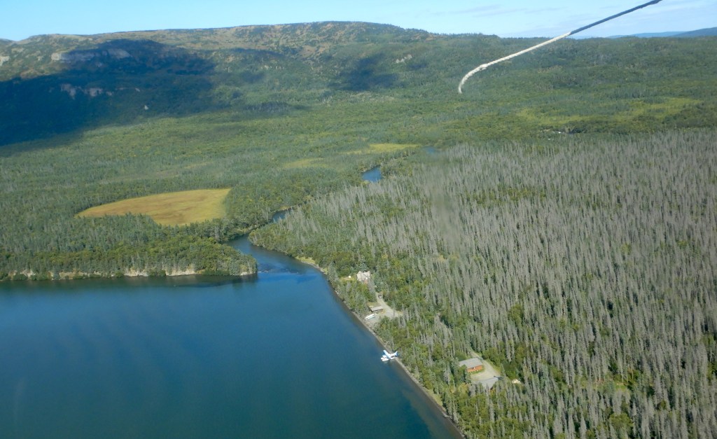
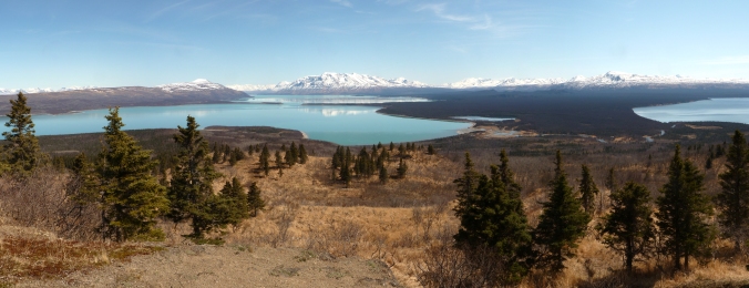
A complex wilderness panorama stretches to every horizon. A rugged volcanic arc—the ragged crest of the Aleutian Range—marks the eastern and southern skylines. Flanked by reposed Mount La Gorce and the sharp, angular ridges of Mount Katolinat, Naknek Lake emerges from the foot of the mountains and fills much of the nearby low elevations. Directly south, Brooks River meanders through dense spruce forests before its clear water spins in lazy plumes as it mixes with the turquoise water of the glacial lake.
Without catching a plane ride this overlook provides one of the only places to view the river in its entirety. Brooks River and Brooks Falls look insignificant on the scale of the surrounding landscape. Had I first stumbled up Dumpling Mountain with no prior knowledge of the falls, I’d be hard pressed to even notice the line of white foam marking it.
My gaze shifts back to the mountains and lingers on Mount Mageik, a glacially clad volcano about 30 miles to the southeast. Low clouds and precipitation obscure its coalesced summits from this vista on many days, but today’s weather is atypical. Few clouds hover in the sky and the wind is relatively calm. Under bright sun, Mageik’s glaciers seem so pure and fixed, but this is an illusion of time and scale.
I cannot see the glaciers slowly wearing down Mageik, nor will I live long enough to witness anything more than superficial glacial erosion on it, but the view provokes me to ponder the sea of glacial change that shaped this land. The shape of the valleys and lakes below me, the sediments that Brooks River erodes, and even the color of Naknek Lake are all products of glaciers. The full story of Katmai’s glaciers spans a geologic epoch and reaches to land now flooded by the Bering Sea. Until relatively recently, glaciers were this area’s most ubiquitous and prominent agent of geologic change.
The view looking east from an overlook on Dumpling Mountain. Brooks River is located at lower right.
Mageik’s glaciers, like all glaciers, are a product of climate, and the Alaska Peninsula has a well-deserved reputation as a damp and chilly place. Climate data for the region is limited, but enough has been gathered from airport and remote automated weather stations to draw some conclusions about the precipitation patterns affecting the area’s glacier formation and growth.
Katmai National Park lies at the head of the Alaska Peninsula, a northeast-southwest trending arc of land jutting into the North Pacific and Bering Sea. The peninsula’s location and orientation expose it to the vast majority of storms bred from the Aleutian Low, a semi-permanent low-pressure system originating near the outer Aleutian Islands. The peninsula’s mountains represent a major topographical barrier to these northeast-tracking storms, forcing warm oceanic air to rise and cool. Water vapor condenses under these conditions and frequently falls as rain or snow. If the day’s weather is damp at Brooks Camp, it is almost certainly wetter along the crest of the Aleutian Range. While inland valleys north and west of the Aleutian Range are spared the full brunt of Pacific and Bering Sea storms, they still may receive about 40 inches of precipitation per year. At higher elevations, though, precipitation increases dramatically. Computer models indicate the volcanic peaks, like Mount Mageik, where snow can accumulate year-round, receive over 98 inches (250 cm) of annual precipitation, enough to qualify as a rainforest if trees could grow there. When global temperatures were as much as 10˚C colder during the Pleistocene Epoch, about 2.6 million to 12,000 years ago, most precipitation over the Alaska Peninsula fell as snow and little melted compared to today. Conditions were ripe for the formation and growth of glaciers.
Thirty thousand years ago, Dumpling Mountain was an island in a glacial sea. Even the overlook where I sit, over 700 feet above Naknek Lake, was smothered by ice. Naknek Lake, the Brooks River area, and nearly all of Katmai were buried. From an ice cap centered over Cook Inlet and Shelikof Strait, glaciers pushed west and north through gaps in the Aleutian Range near Lake Iliamna and Becharof Lake. Ice overrode almost all of nearby Kodiak Island and all of Cook Inlet to the northeast. Glaciers sourced from the volcanic peaks moved through the entire Naknek Lake watershed and over the future site of Brooks River. Almost no land was exposed in Ice Age Katmai except for rare nunataks, isolated mountains projecting above the ice and snow. Off of Alaska’s southern coast, ice extended to the outer edge of the continental shelf, over what is now only open ocean. Glaciers covered three hundred thousand square kilometers of the Alaska Peninsula, an area about as large as Arizona.
Similar scenes were found across the Northern Hemisphere when ice covered as much as 30 percent of Earth’s surface. In North America, ice sheets reached beyond the present locations of Boston, New York City, and Chicago. Glaciers trapped so much water to lower sea levels by almost 400 feet compared to present day. As a result, Bristol Bay and the Bering Sea, now harboring one of the world’s most valuable fisheries, didn’t exist. In their place, low sea levels exposed Beringia, the subcontinent connecting western Alaska and eastern Siberia. In Katmai, there were no bears or salmon. No forests or lakes. No people. Almost no habitat for the living. Ice was the most extensive and dominant force of change.
Amazingly, all glaciers begin as fragile snowflakes. Snow is ice, but it isn’t very dense. By volume, newly fallen snow is ninety percent air, and individual snowflakes break easily as they settle, compress, or become wet. Freshly fallen snow seems inconsequential to rock. Given enough time and the right conditions, though, snow transforms into a force powerful enough to move mountains.
Snow turns into glacier ice in several stages. First, old snow must survive through summer into winter when it can become buried by new snow. Surviving snow has a granular texture and become harder and denser as it compress under the weight of succeeding layers. Typically within a year, snow granules reach a density about half of liquid water and become firn, an intermediate stage between snow and glacier ice. In its transition to glacier ice, firn recrystallizes and changes shape repeatedly under the influences of percolating melt water, freeze-thaw cycles, and the weight of additional snow. Lastly, firn completes its transformation into glacial ice when air is either squeezed out or trapped as bubbles. In temperate areas this process can transform airy snowflakes into dense blue ice in as little as five years.
A block of ice makes not a glacier, however. Take an ice cube out of the freezer, set it on a table, strike it with a hammer and it will fracture. Due to their mass, the ice inside glaciers behaves differently. Glacial ice experiences enormous pressure, so much so that only the upper 100 feet of temperate glaciers are brittle (a fact revealed by the relatively consistent maximum depth of crevasses). Below this depth, pressure from the overlying ice deforms the ice beneath to seal any voids. Cavities at the base of glaciers have been measured to seal as fast as 10 inches per day. A true glacier flows and deforms under its own mass.
The ice is not impervious to liquid water though. Within the glacier, ice remains at or slightly above freezing, and meltwater percolates to the glacier’s base. High pressure at the base of a glacier also causes melting. Meltwater under a glacier acts as a lubricant helping the glacier slide. These factors, combined with gravity’s pull, drive glaciers along the paths of least resistance.
Not that glaciers stop when they encounter resistance. The erosional power of glaciers can substantially transform a landscape. Glacial movement works the earth like a bulldozer and a rock crusher. The ice erodes and entrains rock, sand, and anything else by plucking or abrading it away from the glacier’s base and sides. Stones and debris at a glacier’s bed are especially powerful erosive tools, grinding and crushing rock further. Much of the eroded debris is swept into the glacier’s interior where deformation and sliding eventually carry it into the glacier’s ablation zone, the area on a glacier where ice is lost and all of the previous winter’s snow melts. Advancing glaciers accumulate and eventually deposit thick mantles of till this way.
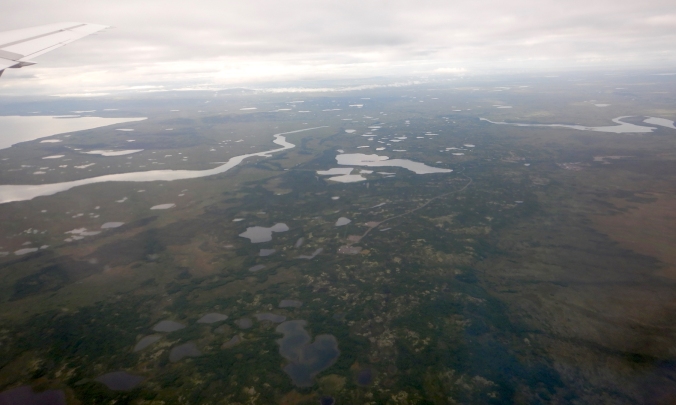
Over several large stades, or individual advances, glaciers quarried much of the Aleutian Range. Marching toward Beringia, they carried their eroded cargo far from its source and dropped it when climate no longer supported further advance. The largest, oldest, and most extensive glacial deposits in the region are too far away for me to see from the overlook, but when I turn and face southwest I glimpse a fraction of their extent. Beyond the western shore of Lake Brooks, the mountains stop and a broad plain stretches to the horizon. The power and work of glaciers is demonstrated dramatically by the mere fact this area, the Bristol Bay lowlands, even exists.
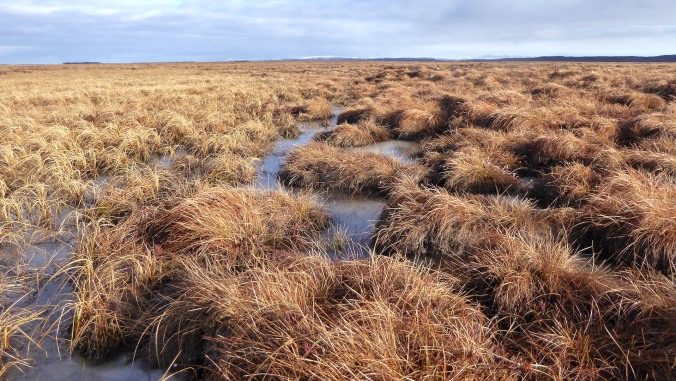
The Bristol Bay Lowlands are composed almost entirely of glacial sediments deposited during the last ice age.Wet sedge tundra is the dominant plant cover across much of the Bristol Bay lowlands.
The nearest communities to Brooks River, King Salmon and Naknek, sit well within the lowlands. It’s a buggy, waterlogged place harboring millions of acres of wetlands and tundra. If the Aleutian Range volcanoes and coastal fjords on Shelikof Strait define Katmai’s ruggedness, then the lowlands represent its smoother alter ego, or so it would appear. Hiking on the wet tundra removes the façade. It is an exhausting slog over sedge tussocks that feel and behave underfoot like piles of water-laden pillows. Wind is about the only thing that crosses the lowlands easily, which provides respite from summer’s vampiric black flies but also brings life-threatening cold in winter.
With exceptions for wind-born volcanic ash, sediments reworked by water, and a mantle of peat and vegetation, the Bristol Bay lowlands were entirely created by the glaciers’ assault on the mountains. These are the oldest glacial deposits in the Katmai region, at least 40,000 years old. The till and outwash is even older near the town of Naknek and the Bering Sea coast, exceeding the age limits of radio carbon dating. Glaciers removed so much material from the mountains and carried it to the coastal plain that half of the Alaska Peninsula is glacially derived. Without these glacial deposits, at twentieth century sea levels the Aleutian Islands would begin fewer than 200 miles from Brooks River and water pouring over Brooks Falls would nearly reach tidewater. Naknek Lake would likely be a marine embayment.
The Ice Age was a time of profound geologic change, when the surface of Katmai and Brooks River was constantly reworked by ice. Glacial movements across the region were inconsistent, however. For tens of thousands of years, in response to a fluctuating climate, the area’s glaciers advanced and receded in fits and starts. Within the last 30,000 years, they plowed ahead many separate times. In between stades, when climatic conditions grew too warm, they stagnated or shrunk. West of the park, near King Salmon and Naknek, only faint hills of low relief trace the maximum extent of the most ancient stades, but younger and less extensive advances have been less affected by post-glacial erosion. Their signatures are scribed over the entire Naknek Lake basin.
The last glacier to entirely fill the area now occupied by Naknek Lake, which I refer to informally as the Naknek glacier, reached its greatest extent no sooner than 23,000 years ago. Part of an advance called the Iliamna Stade, it carried ice 60 miles from its source area on the Aleutian Range to its terminus on the lowlands. Topography funneled this glacier into mountain valleys, but to the west of Dumpling it was unbound and free to deform in multiple directions.
Perhaps the best modern analog for the shape and behavior of the ancient Naknek glacier may be Malaspina Glacier in Wrangell-Saint Elias National Park. Malaspina originates high in the Saint Elias Mountains where extensive ice fields more closely resemble high Antarctic landscapes than anything else in North America. As the ice flows to lower elevations, topography sufficiently constrains its source glaciers to valleys. But the Malaspina faces no such barrier as it flows beyond the mountains onto a coastal plain at the edge of the Pacific. Free of the restricting mountain topography, Malaspina deforms outward like a fan of thick batter spilled onto a tabletop. During the Iliamna Stade, circa 30,000 years ago, Naknek glacier looked much the same, flowing from roots in the mountains to a bulbous terminus at the edge of the lowlands. No glacial advance since has been as extensive or influential to Katmai’s geography, ecology, and history.
The Naknek glacier’s size, extent, and erosive power allowed it to accumulate huge amounts of till near its terminus. Much of its eroded debris was trapped within the ice and carried forward. Lesser amounts were pushed ahead as the glacier acted like an indiscriminate bulldozer. When the ice stagnated or receded, the reworked earth was dropped in place creating a terminal moraine, the ridge of till at the farthest reach of the glacier’s snout.
The glaciers of the Iliamna stade, especially the Naknek, thoroughly shaped the modern-day lake basins surrounding Brooks River. Its maximum advance is clearly inscribed on the land by the terminal moraine that now dams Naknek Lake. From the air this moraine, known locally as Pike Ridge, looks like a bore tide of earth flowing toward Bristol Bay. The moraine’s surface is uneven, hummocky, and pockmarked by kettle lakes. Vegetation covers most of it, hiding the raw frigidness of its formative time, but debris of all sizes, everything from clay and sand to car-sized boulders dot its surface. The moraine’s breadth—it spoons the western edge of Naknek Lake for 19 miles north to south—reveals how massive the glacier was as it greatest extent.
Pike Ridge is the terminal moraine of an Ice Age glacier. In this view, the moraine is the hummocky area at center covered in sparse spruce woodlands. Ice flowed from left (east) to right (west) when it deposited the moraine. Naknek River flows through the moraine at the center.
Near the end of the Pleistocene a warming climate never allowed the Naknek glacier to flow as far the Pike Ridge moraine. Each subsequent re-advance was eventually met by warmer and warmer conditions. The erosive and depositional influences of glaciers were waning even as the ice continued to leave its mark.
Between 23,000 and 10,000 years ago, several younger advances plowed through the same basins as the Naknek. While they failed to advance as far as the Iliamna stade, these smaller valley-filling glaciers were not inconsequential. They reworked previously deposited till, eroded bedrock further, and formed large moraines that are still visible. The North Arm of Naknek Lake and the west end of Lake Brooks are constrained by moraines from one such re-advance, the Newhalen Stade. Twenty thousand years ago, a last major resurgence pushed ice though Iliuk Arm toward Dumpling Mountain and the future site of Brooks River, halting only two miles from the present day river mouth.
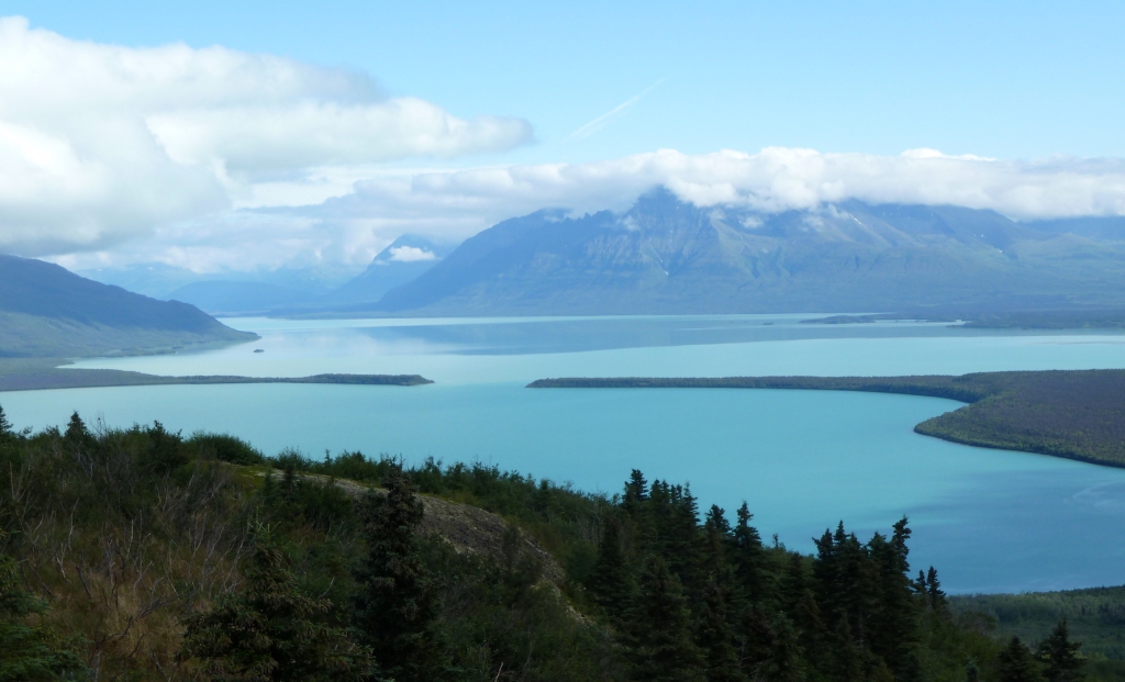
The Iliuk was the last great stade in Katmai, and its moraine is one of the most prominent geologic features within my line of sight. Iliuk Arm, Naknek Lake’s southeastern-most appendage, sits on its far side. Water from Iliuk Arm flows into greater Naknek Lake through a breach in the moraine, a break which creates fingers of land reaching toward each other like the outstretched arms in Michelangelo’s Creation of Adam.
The slopes of Mount La Gorce and Katolinat dip steeply behind Iliuk moraine where the lake plunges to great depths. Unlike Naknek Lake’s western basin where glaciers were free to splay in broad lobes, the mountain topography on either side of Iliuk Arm restricted the outward flow of ice, but not its forward movement or erosive power. The topographical pinch enhanced and accelerated downward erosion in Iliuk Arm, over-deepening it. While the far western basin of Naknek Lake is often a mere 30 feet deep or less, the abyss of Iliuk Arm is at least 580 feet deep. With Naknek Lake’s surface averaging about 30 feet, Iliuk Arm reaches at least 550 feet below sea level.
The Iliuk Moraine bounds Iliuk Arm of Naknek Lake. Savonoski and Ukak rivers, two waterways originating from modern-day glacial melt, empty into the lake at center.
All of these events have come and gone. Glaciers no longer spill into Iliuk Arm or threaten to overrun the overlook where I sit. No glacier has even advanced within 16 miles of the Iliuk moraine after it formed. Since then, Katmai’s glaciers have retreated to the crest of the Aleutian Range where volcanoes like Mount Mageik still harbor the right climate for their formation. Katmai’s glaciers are remnants of their former selves, yet I need not search long to see evidence that they still work the mountains. Through binoculars I spy Naknek Lake’s largest tributaries at the far end of Iliuk Arm, Savonoski and Ukak rivers. These rivers collectively drain much of central Katmai and each carry astounding loads of sediment eroded by glaciers on the Aleutian Range volcanoes.
I first canoed Savonoski River after paddling for two tranquil days on Lake Grosvenor, a crystal clear lake fed only by springs, unclouded creeks, rain, and snow. My canoe partner and I paddled casually to Grosvenor’s outlet stream. Conditions were placid and there wasn’t much of a need to rush. We relaxed at Grosvenor’s outlet as the flow pulled us downstream. After an hour of easy paddling, our trance was broken when we saw the outlet merge with Savonoski River. It was the antithesis of Grosvenor’s calm.
Savonoski was murky, swift, braided, and shockingly cold. There was no reliable way to judge any one channel’s depth from a distance. The water was so turbid that my fingertips disappeared from view mere inches below the surface. The river didn’t just look thick. It sounded thick, hissing with fine rock that sang off of the bottom of the aluminum canoe. We watched whole spruce trees tumble in the muddy water and carefully avoided others sweeping perpendicularly into the current. Near Naknek Lake, the river spread wide at its confluence with Ukak. On this delta, Iliuk Arm looked like a fjord on a stormy coastline.
Savonoski’s characteristics—icy water, braided channels, and the heavy sediment load—mark it as a classic glacially fed river. Its water pours out of the Hook and Serpent Tongue glaciers, which incessantly grind down some of the tallest volcanoes in Katmai. Much of the river’s larger sediments never arrive in Iliuk Arm, having been dropped anywhere the river’s energy is too weak to carry them further, but the glaciers mill some rock so finely it becomes microscopic, clay-sized bits called rock flour.
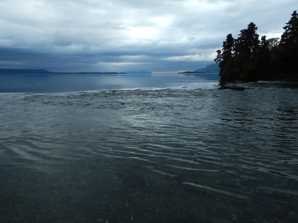
The name is apt. Rock flour has the size and texture of the finest white bread flour, ranging from 1 – 100 microns (a micron or micrometer is one millionth of a meter). The biggest rock flour particles, generally larger than 40 microns, are temporary inhabitants of the water column. They remain suspended if the water is continuously disturbed; such is the case in the fast moving Savonoski River where the water resembles a pale gray milk, but the bigger particles tend to sink quickly after reaching the calmer lake. The smallest rock flour particles, however, have a tendency to repel one another, not flocculate, which would cause them clump to sink faster. They are so small that friction in the water column allows them to remain in suspension for months even though they are insoluble. This makes the lake water in Iliuk Arm and near the mouth of Brooks River colloidal, a mix of microscopic insoluble particles (like rock flour) suspended in a second substance (like water). While many lakes in northern latitudes are exceptionally clear (visibility in nearby Lake Brooks extends dozens of feet into the water column) Iliuk Arm holds so much rock flour that visibility is often less than three feet many miles from the Savonoski.
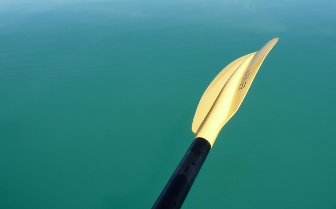
Rock flour’s physical and chemical characteristics lend a deep vibrancy to Iliuk Arm. Naknek Lake shimmers opaquely, but not the pewter tone of lakes under overcasts skies. Instead it’s a garish turquoise blue. Suspended in the water column, rock flour scatters blue and green wavelengths of light exceptionally well creating the rich hues that meets my eyes. Drifting on Iliuk Arm in a kayak on a calm sunny day, surrounded by blue above and enveloped by turquoise underneath, looks and feels like paddling in sky.
Iliuk Arm and other glacially fed lakes owe their alluring look to the microscopically ground rock, but in many ways this is the least of the changes wrought by glaciers. Katmai and the Brooks River area were profoundly changed by ice. Almost every surface feature I see from the overlook has felt the effects. Glaciers repeatedly scoured the land and enveloped it for thousands of years. They ground much of the mountains to powder and moved a lot of the rest nearly to the Bering Sea. Without glaciers, the history and ecology of Brooks River and the entire region would be profoundly different. Yet this is a landscape that continues to evolve. Glaciers only sculpted the stage.
The turquoise water of Iliuk Arm illustrates that glaciers continue to work Katmai’s landscape.
References and Notes:
Aleutian Low and atmospheric ability to hold moisture: Shulski, M. and G. Wendler. 2007. The Climate of Alaska. University of Alaska Press. Pg. 59, 96-99.
Precipitation models for Alaska: PRISM Climate Group. Oregon State University. http://prism.oregonstate.edu. Created 7 Feb 2017.
Many thousands of years ago precipitation patterns were very similar across southwest Alaska: Hults, C. P. and J. Fierstein. 2016. Katmai National Park and Preserve and Alagnak Wild River: Geologic Resources Inventory report. Natural Resource Report NPS/NRSS/GRD/NRR—2016/1314. National Park Service, Fort Collins, Colorado. Pg. 41.
Global temperatures were as much as 10˚C colder than today: Petit, J. R., et al. 1999. Climate and atmospheric history of the past 420,000 years from the Vostok ice core, Antarctica. Nature 399 (6735): 429–436.
Ice movement and glacial coverage on the Alaska Peninsula: Mann, D. H., and D. M. Peteet. 1994. Extent and Timing of the Last Glacial Maximum in Southwest Alaska. Quaternary Research 42: 136-148.
Newly fallen snow is ninety percent air: Collier, M. 2004. Sculpted by Ice: Glaciers and the Alaska Landscape. Alaska Geographic Association. Pg. 66.
Information on the properties of glacier ice, formation, deformation, and movement: Hambrey, M. and Jurg, A. 2004. Glaciers, 2nd Edition. Cambridge University Press.
Cavities at the base of glaciers have been measured to contract and seal as fast as 25 centimeters per day: Lefeuvre, J. and Lappegard, H. 2015. Interannual Variability of Glacial Basal Pressure from a Twenty Year Record. Annals of Glaciology. V. 56. No. 70.
Ages of glacial stades in Katmai: Hults, C. P. and J. Fierstein. 2016. Katmai National Park and Preserve and Alagnak Wild River: Geologic Resources Inventory report. Natural Resource Report NPS/NRSS/GRD/NRR—2016/1314. National Park Service, Fort Collins, Colorado.
Fifty percent of AK Peninsula is glacially derived, Aleutian Islands would begin a scant 300 kilometers from Brooks River: Detterman, R. L. 1986. Glaciation of the Alaska Peninsula. Pg. 151–170 in T. D. Hamilton, K. M. Reed, and R. M. Thorson, editors. Glaciation in Alaska: The geologic record. Alaska Geological Society, Anchorage, Alaska.
The best modern analogs for the shape and behavior of the ancient Naknek glacier may be Malaspina and Bering glaciers: I was first introduced to this comparison in Reihle, J. 2002. The Geology of Katmai National Park and Preserve. Publication Consultants.
Depth of Naknek Lake basins including Iliuk Arm: The exact depth of Naknek Lake is unknown. The estimates are based on sonar readings on boats in Naknek Lake; personal communications with Troy Hamon, Katmai’s Chief of Cultural and Natural Resources; and an unpublished lake bathymetry map provided by Chad Hults, geologist with the National Park Service, Alaska Regional Office.
Rock Flour:
Ben, D. I. 2009. Glacial Sediments, Pg. 382 inV. Gornitz, editor. Encyclopedia of Paleoclimatology and Ancient Environments. Springer.
Nichols, G. 2009. Sedimentology and Stratigraphy, 2nd Edition. Wiley-Blackwell. Pg. 107.
Friction in the water column allows [rock flour] to remain in suspension for months: As far as I know, this has not been empirically tested. However, Iliuk Arm retains its vibrant, turquoise hue even in winter when Savonoski River runs clear and flow out of Ukak River is at a bare minimum.
Visibility in Lake Brooks and Iliuk Arm: Moore, C. and J. Shearer. 2011. Water quality and Surface Hydrology of Freshwater Flow Systems in Southwest Alaska: 2010 Annual Summary Report. Natural Resource Technical Report NPS/SWAN/NRTR—2011/428. National Park Service, Fort Collins, Colorado.