I never understood how difficult writing a book can be until I tried it. The brainstorming. The planning. The research. Pitching agents (none were interested). Pitching publishers (I got lucky). The worry. The self-doubt. The first draft. The first, second, and third revisions. The Nth revisions.
Finally, after months and sometimes years, you’re left with a book that you hope will bring some joy and meaning to people and place. Writing The Bears of Brooks Falls: Wildlife and Survival on Brooks River is the culmination of my years of study and observation at one of the most unique and special places in America’s national parks.
Through the drafting process, I wrote, revised, and cut more sentences and paragraphs than I can remember. While revision is often difficult, this is where, for me, the pleasure of writing expresses itself most often. Only through revision can I work through the nonsense and polish the narrative so it reads—I hope—in a logical, intelligent, and engaging manner.
During the drafting and revision process, I cut large sections and even whole chapters from the final manuscript as I discovered new or more concise ways to frame the story of Brooks River. Today, I present a chapter sacrificed for the greater good. Some of it was incorporated into the print and digital versions of The Bears of Brooks Falls, but as I progressed deeper into the manuscript I realized this particular essay needed to be cut so that the narrative could focus more on the brown bears, salmon, and people of Brooks River. I present it here as an online-only chapter for your reading pleasure, illustrated with photos and only lightly edited from its final draft.
Sit back and relax. This is a long read.
In the coming weeks, please check my blog and Twitter feed to find details about how to order signed copies of The Bears of Brooks Falls. And, be sure to ask for it at your favorite independent bookstore. The book ships out March 9, 2021.
Sculptor
I open the gate on the north side of the campground and latch it behind me, careful to avoid the live wires strung horizontally from post to post. The electric fence is an oddity for a national park campground, yet one that is necessary to prevent bears from pressing their noses against the sides of nylon tents.
Outside the campground, following a narrow trail through forest, the world seems to shrink. Thick vegetation limits views of the surrounding landscape. The Dumpling Mountain Trail ascends through a thick understory of head-high grass, shrubby willows, and the corduroyed stalks of cow parsnip. Above the trail hovers a semi-closed canopy of birch and poplar leaves. I’m eager to reach the tree line, which the regional climate keeps at about 1,000 feet above sea level in central Katmai, and explore more open vistas. I march on despite the trail’s steepness.
After forty minutes of brisk travel, I arrive at a small rocky knob where the forest transitions to alder thickets and grassy meadows speckled with the occasional white spruce. Here I stop, not so much because I am winded, but because the perch is one of my favorite spots to loiter.
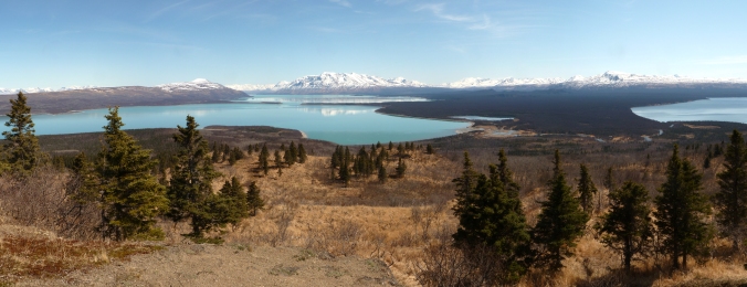
A complex wilderness panorama stretches to every horizon. A rugged volcanic arc—the ragged crest of the Aleutian Range—marks the eastern and southern skylines. Flanked by reposed Mount La Gorce and the sharp, angular ridges of Mount Katolinat, Naknek Lake emerges from the foot of the mountains and fills much of the nearby low elevations. Directly south, Brooks River meanders through dense spruce forests before its clear water spins in lazy plumes as it mixes with the turquoise water of the glacial lake.
Without catching a plane ride this overlook provides one of the only places to view the river in its entirety. Brooks River and Brooks Falls look insignificant on the scale of the surrounding landscape. Had I first stumbled up Dumpling Mountain with no prior knowledge of the falls, I’d be hard pressed to even notice the line of white foam marking it.
My gaze shifts back to the mountains and lingers on Mount Mageik, a glacially clad volcano about 30 miles to the southeast. Low clouds and precipitation obscure its coalesced summits from this vista on many days, but today’s weather is atypical. Few clouds hover in the sky and the wind is relatively calm. Under bright sun, Mageik’s glaciers seem so pure and fixed, but this is an illusion of time and scale.
I cannot see the glaciers slowly wearing down Mageik, nor will I live long enough to witness anything more than superficial glacial erosion on it, but the view provokes me to ponder the sea of glacial change that shaped this land. The shape of the valleys and lakes below me, the sediments that Brooks River erodes, and even the color of Naknek Lake are all products of glaciers. The full story of Katmai’s glaciers spans a geologic epoch and reaches to land now flooded by the Bering Sea. Until relatively recently, glaciers were this area’s most ubiquitous and prominent agent of geologic change.
Mageik’s glaciers, like all glaciers, are a product of climate, and the Alaska Peninsula has a well-deserved reputation as a damp and chilly place. Climate data for the region is limited, but enough has been gathered from airport and remote automated weather stations to draw some conclusions about the precipitation patterns affecting the area’s glacier formation and growth.
Katmai National Park lies at the head of the Alaska Peninsula, a northeast-southwest trending arc of land jutting into the North Pacific and Bering Sea. The peninsula’s location and orientation expose it to the vast majority of storms bred from the Aleutian Low, a semi-permanent low-pressure system originating near the outer Aleutian Islands. The peninsula’s mountains represent a major topographical barrier to these northeast-tracking storms, forcing warm oceanic air to rise and cool. Water vapor condenses under these conditions and frequently falls as rain or snow. If the day’s weather is damp at Brooks Camp, it is almost certainly wetter along the crest of the Aleutian Range. While inland valleys north and west of the Aleutian Range are spared the full brunt of Pacific and Bering Sea storms, they still may receive about 40 inches of precipitation per year. At higher elevations, though, precipitation increases dramatically. Computer models indicate the volcanic peaks, like Mount Mageik, where snow can accumulate year-round, receive over 98 inches (250 cm) of annual precipitation, enough to qualify as a rainforest if trees could grow there. When global temperatures were as much as 10˚C colder during the Pleistocene Epoch, about 2.6 million to 12,000 years ago, most precipitation over the Alaska Peninsula fell as snow and little melted compared to today. Conditions were ripe for the formation and growth of glaciers.
Thirty thousand years ago, Dumpling Mountain was an island in a glacial sea. Even the overlook where I sit, over 700 feet above Naknek Lake, was smothered by ice. Naknek Lake, the Brooks River area, and nearly all of Katmai were buried. From an ice cap centered over Cook Inlet and Shelikof Strait, glaciers pushed west and north through gaps in the Aleutian Range near Lake Iliamna and Becharof Lake. Ice overrode almost all of nearby Kodiak Island and all of Cook Inlet to the northeast. Glaciers sourced from the volcanic peaks moved through the entire Naknek Lake watershed and over the future site of Brooks River. Almost no land was exposed in Ice Age Katmai except for rare nunataks, isolated mountains projecting above the ice and snow. Off of Alaska’s southern coast, ice extended to the outer edge of the continental shelf, over what is now only open ocean. Glaciers covered three hundred thousand square kilometers of the Alaska Peninsula, an area about as large as Arizona.
Similar scenes were found across the Northern Hemisphere when ice covered as much as 30 percent of Earth’s surface. In North America, ice sheets reached beyond the present locations of Boston, New York City, and Chicago. Glaciers trapped so much water to lower sea levels by almost 400 feet compared to present day. As a result, Bristol Bay and the Bering Sea, now harboring one of the world’s most valuable fisheries, didn’t exist. In their place, low sea levels exposed Beringia, the subcontinent connecting western Alaska and eastern Siberia. In Katmai, there were no bears or salmon. No forests or lakes. No people. Almost no habitat for the living. Ice was the most extensive and dominant force of change.
Amazingly, all glaciers begin as fragile snowflakes. Snow is ice, but it isn’t very dense. By volume, newly fallen snow is ninety percent air, and individual snowflakes break easily as they settle, compress, or become wet. Freshly fallen snow seems inconsequential to rock. Given enough time and the right conditions, though, snow transforms into a force powerful enough to move mountains.
Snow turns into glacier ice in several stages. First, old snow must survive through summer into winter when it can become buried by new snow. Surviving snow has a granular texture and become harder and denser as it compress under the weight of succeeding layers. Typically within a year, snow granules reach a density about half of liquid water and become firn, an intermediate stage between snow and glacier ice. In its transition to glacier ice, firn recrystallizes and changes shape repeatedly under the influences of percolating melt water, freeze-thaw cycles, and the weight of additional snow. Lastly, firn completes its transformation into glacial ice when air is either squeezed out or trapped as bubbles. In temperate areas this process can transform airy snowflakes into dense blue ice in as little as five years.
A block of ice makes not a glacier, however. Take an ice cube out of the freezer, set it on a table, strike it with a hammer and it will fracture. Due to their mass, the ice inside glaciers behaves differently. Glacial ice experiences enormous pressure, so much so that only the upper 100 feet of temperate glaciers are brittle (a fact revealed by the relatively consistent maximum depth of crevasses). Below this depth, pressure from the overlying ice deforms the ice beneath to seal any voids. Cavities at the base of glaciers have been measured to seal as fast as 10 inches per day. A true glacier flows and deforms under its own mass.
The ice is not impervious to liquid water though. Within the glacier, ice remains at or slightly above freezing, and meltwater percolates to the glacier’s base. High pressure at the base of a glacier also causes melting. Meltwater under a glacier acts as a lubricant helping the glacier slide. These factors, combined with gravity’s pull, drive glaciers along the paths of least resistance.
Not that glaciers stop when they encounter resistance. The erosional power of glaciers can substantially transform a landscape. Glacial movement works the earth like a bulldozer and a rock crusher. The ice erodes and entrains rock, sand, and anything else by plucking or abrading it away from the glacier’s base and sides. Stones and debris at a glacier’s bed are especially powerful erosive tools, grinding and crushing rock further. Much of the eroded debris is swept into the glacier’s interior where deformation and sliding eventually carry it into the glacier’s ablation zone, the area on a glacier where ice is lost and all of the previous winter’s snow melts. Advancing glaciers accumulate and eventually deposit thick mantles of till this way.
Over several large stades, or individual advances, glaciers quarried much of the Aleutian Range. Marching toward Beringia, they carried their eroded cargo far from its source and dropped it when climate no longer supported further advance. The largest, oldest, and most extensive glacial deposits in the region are too far away for me to see from the overlook, but when I turn and face southwest I glimpse a fraction of their extent. Beyond the western shore of Lake Brooks, the mountains stop and a broad plain stretches to the horizon. The power and work of glaciers is demonstrated dramatically by the mere fact this area, the Bristol Bay lowlands, even exists.

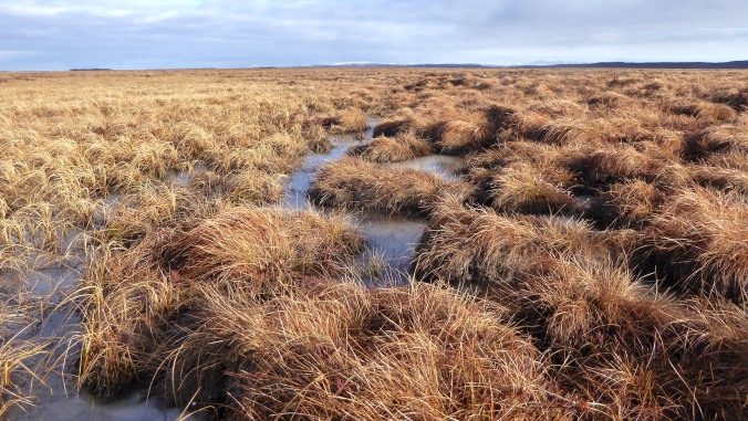
The nearest communities to Brooks River, King Salmon and Naknek, sit well within the lowlands. It’s a buggy, waterlogged place harboring millions of acres of wetlands and tundra. If the Aleutian Range volcanoes and coastal fjords on Shelikof Strait define Katmai’s ruggedness, then the lowlands represent its smoother alter ego, or so it would appear. Hiking on the wet tundra removes the façade. It is an exhausting slog over sedge tussocks that feel and behave underfoot like piles of water-laden pillows. Wind is about the only thing that crosses the lowlands easily, which provides respite from summer’s vampiric black flies but also brings life-threatening cold in winter.
With exceptions for wind-born volcanic ash, sediments reworked by water, and a mantle of peat and vegetation, the Bristol Bay lowlands were entirely created by the glaciers’ assault on the mountains. These are the oldest glacial deposits in the Katmai region, at least 40,000 years old. The till and outwash is even older near the town of Naknek and the Bering Sea coast, exceeding the age limits of radio carbon dating. Glaciers removed so much material from the mountains and carried it to the coastal plain that half of the Alaska Peninsula is glacially derived. Without these glacial deposits, at twentieth century sea levels the Aleutian Islands would begin fewer than 200 miles from Brooks River and water pouring over Brooks Falls would nearly reach tidewater. Naknek Lake would likely be a marine embayment.
The Ice Age was a time of profound geologic change, when the surface of Katmai and Brooks River was constantly reworked by ice. Glacial movements across the region were inconsistent, however. For tens of thousands of years, in response to a fluctuating climate, the area’s glaciers advanced and receded in fits and starts. Within the last 30,000 years, they plowed ahead many separate times. In between stades, when climatic conditions grew too warm, they stagnated or shrunk. West of the park, near King Salmon and Naknek, only faint hills of low relief trace the maximum extent of the most ancient stades, but younger and less extensive advances have been less affected by post-glacial erosion. Their signatures are scribed over the entire Naknek Lake basin.
The last glacier to entirely fill the area now occupied by Naknek Lake, which I refer to informally as the Naknek glacier, reached its greatest extent no sooner than 23,000 years ago. Part of an advance called the Iliamna Stade, it carried ice 60 miles from its source area on the Aleutian Range to its terminus on the lowlands. Topography funneled this glacier into mountain valleys, but to the west of Dumpling it was unbound and free to deform in multiple directions.
Perhaps the best modern analog for the shape and behavior of the ancient Naknek glacier may be Malaspina Glacier in Wrangell-Saint Elias National Park. Malaspina originates high in the Saint Elias Mountains where extensive ice fields more closely resemble high Antarctic landscapes than anything else in North America. As the ice flows to lower elevations, topography sufficiently constrains its source glaciers to valleys. But the Malaspina faces no such barrier as it flows beyond the mountains onto a coastal plain at the edge of the Pacific. Free of the restricting mountain topography, Malaspina deforms outward like a fan of thick batter spilled onto a tabletop. During the Iliamna Stade, circa 30,000 years ago, Naknek glacier looked much the same, flowing from roots in the mountains to a bulbous terminus at the edge of the lowlands. No glacial advance since has been as extensive or influential to Katmai’s geography, ecology, and history.
The Naknek glacier’s size, extent, and erosive power allowed it to accumulate huge amounts of till near its terminus. Much of its eroded debris was trapped within the ice and carried forward. Lesser amounts were pushed ahead as the glacier acted like an indiscriminate bulldozer. When the ice stagnated or receded, the reworked earth was dropped in place creating a terminal moraine, the ridge of till at the farthest reach of the glacier’s snout.
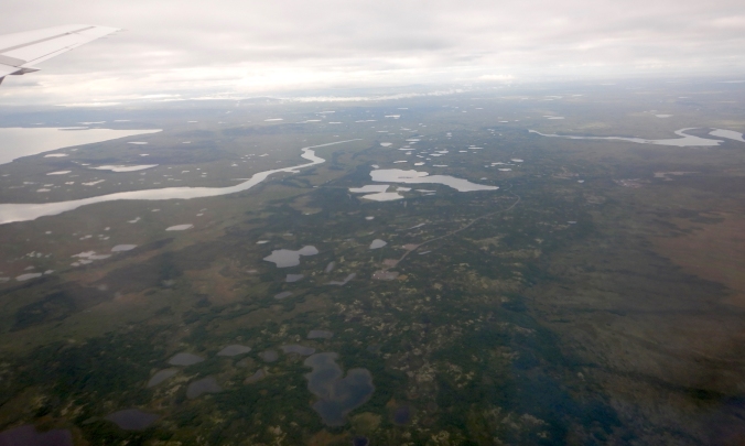
The glaciers of the Iliamna stade, especially the Naknek, thoroughly shaped the modern-day lake basins surrounding Brooks River. Its maximum advance is clearly inscribed on the land by the terminal moraine that now dams Naknek Lake. From the air this moraine, known locally as Pike Ridge, looks like a bore tide of earth flowing toward Bristol Bay. The moraine’s surface is uneven, hummocky, and pockmarked by kettle lakes. Vegetation covers most of it, hiding the raw frigidness of its formative time, but debris of all sizes, everything from clay and sand to car-sized boulders dot its surface. The moraine’s breadth—it spoons the western edge of Naknek Lake for 19 miles north to south—reveals how massive the glacier was as it greatest extent.
Near the end of the Pleistocene a warming climate never allowed the Naknek glacier to flow as far the Pike Ridge moraine. Each subsequent re-advance was eventually met by warmer and warmer conditions. The erosive and depositional influences of glaciers were waning even as the ice continued to leave its mark.
Between 23,000 and 10,000 years ago, several younger advances plowed through the same basins as the Naknek. While they failed to advance as far as the Iliamna stade, these smaller valley-filling glaciers were not inconsequential. They reworked previously deposited till, eroded bedrock further, and formed large moraines that are still visible. The North Arm of Naknek Lake and the west end of Lake Brooks are constrained by moraines from one such re-advance, the Newhalen Stade. Twenty thousand years ago, a last major resurgence pushed ice though Iliuk Arm toward Dumpling Mountain and the future site of Brooks River, halting only two miles from the present day river mouth.
The Iliuk was the last great stade in Katmai, and its moraine is one of the most prominent geologic features within my line of sight. Iliuk Arm, Naknek Lake’s southeastern-most appendage, sits on its far side. Water from Iliuk Arm flows into greater Naknek Lake through a breach in the moraine, a break which creates fingers of land reaching toward each other like the outstretched arms in Michelangelo’s Creation of Adam.
The slopes of Mount La Gorce and Katolinat dip steeply behind Iliuk moraine where the lake plunges to great depths. Unlike Naknek Lake’s western basin where glaciers were free to splay in broad lobes, the mountain topography on either side of Iliuk Arm restricted the outward flow of ice, but not its forward movement or erosive power. The topographical pinch enhanced and accelerated downward erosion in Iliuk Arm, over-deepening it. While the far western basin of Naknek Lake is often a mere 30 feet deep or less, the abyss of Iliuk Arm is at least 580 feet deep. With Naknek Lake’s surface averaging about 30 feet, Iliuk Arm reaches at least 550 feet below sea level.
All of these events have come and gone. Glaciers no longer spill into Iliuk Arm or threaten to overrun the overlook where I sit. No glacier has even advanced within 16 miles of the Iliuk moraine after it formed. Since then, Katmai’s glaciers have retreated to the crest of the Aleutian Range where volcanoes like Mount Mageik still harbor the right climate for their formation. Katmai’s glaciers are remnants of their former selves, yet I need not search long to see evidence that they still work the mountains. Through binoculars I spy Naknek Lake’s largest tributaries at the far end of Iliuk Arm, Savonoski and Ukak rivers. These rivers collectively drain much of central Katmai and each carry astounding loads of sediment eroded by glaciers on the Aleutian Range volcanoes.
I first canoed Savonoski River after paddling for two tranquil days on Lake Grosvenor, a crystal clear lake fed only by springs, unclouded creeks, rain, and snow. My canoe partner and I paddled casually to Grosvenor’s outlet stream. Conditions were placid and there wasn’t much of a need to rush. We relaxed at Grosvenor’s outlet as the flow pulled us downstream. After an hour of easy paddling, our trance was broken when we saw the outlet merge with Savonoski River. It was the antithesis of Grosvenor’s calm.
Savonoski was murky, swift, braided, and shockingly cold. There was no reliable way to judge any one channel’s depth from a distance. The water was so turbid that my fingertips disappeared from view mere inches below the surface. The river didn’t just look thick. It sounded thick, hissing with fine rock that sang off of the bottom of the aluminum canoe. We watched whole spruce trees tumble in the muddy water and carefully avoided others sweeping perpendicularly into the current. Near Naknek Lake, the river spread wide at its confluence with Ukak. On this delta, Iliuk Arm looked like a fjord on a stormy coastline.
Savonoski’s characteristics—icy water, braided channels, and the heavy sediment load—mark it as a classic glacially fed river. Its water pours out of the Hook and Serpent Tongue glaciers, which incessantly grind down some of the tallest volcanoes in Katmai. Much of the river’s larger sediments never arrive in Iliuk Arm, having been dropped anywhere the river’s energy is too weak to carry them further, but the glaciers mill some rock so finely it becomes microscopic, clay-sized bits called rock flour.
The name is apt. Rock flour has the size and texture of the finest white bread flour, ranging from 1 – 100 microns (a micron or micrometer is one millionth of a meter). The biggest rock flour particles, generally larger than 40 microns, are temporary inhabitants of the water column. They remain suspended if the water is continuously disturbed; such is the case in the fast moving Savonoski River where the water resembles a pale gray milk, but the bigger particles tend to sink quickly after reaching the calmer lake. The smallest rock flour particles, however, have a tendency to repel one another, not flocculate, which would cause them clump to sink faster. They are so small that friction in the water column allows them to remain in suspension for months even though they are insoluble. This makes the lake water in Iliuk Arm and near the mouth of Brooks River colloidal, a mix of microscopic insoluble particles (like rock flour) suspended in a second substance (like water). While many lakes in northern latitudes are exceptionally clear (visibility in nearby Lake Brooks extends dozens of feet into the water column) Iliuk Arm holds so much rock flour that visibility is often less than three feet many miles from the Savonoski.
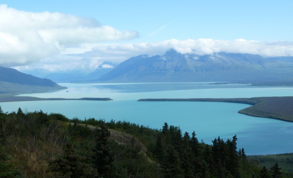
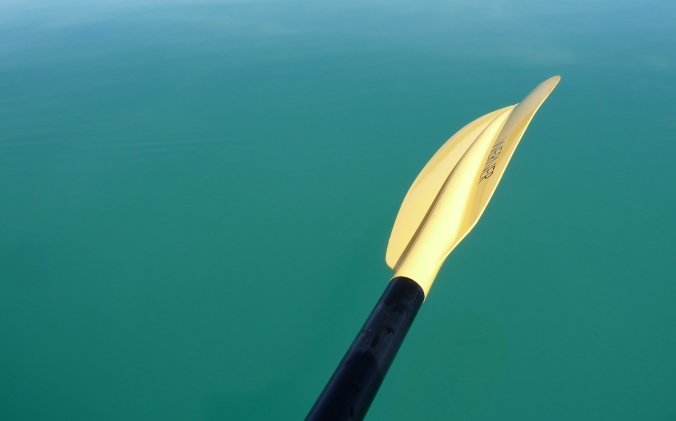
Rock flour’s physical and chemical characteristics lend a deep vibrancy to Iliuk Arm. Naknek Lake shimmers opaquely, but not the pewter tone of lakes under overcasts skies. Instead it’s a garish turquoise blue. Suspended in the water column, rock flour scatters blue and green wavelengths of light exceptionally well creating the rich hues that meets my eyes. Drifting on Iliuk Arm in a kayak on a calm sunny day, surrounded by blue above and enveloped by turquoise underneath, looks and feels like paddling in sky.
Iliuk Arm and other glacially fed lakes owe their alluring look to the microscopically ground rock, but in many ways this is the least of the changes wrought by glaciers. Katmai and the Brooks River area were profoundly changed by ice. Almost every surface feature I see from the overlook has felt the effects. Glaciers repeatedly scoured the land and enveloped it for thousands of years. They ground much of the mountains to powder and moved a lot of the rest nearly to the Bering Sea. Without glaciers, the history and ecology of Brooks River and the entire region would be profoundly different. Yet this is a landscape that continues to evolve. Glaciers only sculpted the stage.
References and Notes:
Aleutian Low and atmospheric ability to hold moisture: Shulski, M. and G. Wendler. 2007. The Climate of Alaska. University of Alaska Press. Pg. 59, 96-99.
Precipitation models for Alaska: PRISM Climate Group. Oregon State University. http://prism.oregonstate.edu. Created 7 Feb 2017.
Many thousands of years ago precipitation patterns were very similar across southwest Alaska: Hults, C. P. and J. Fierstein. 2016. Katmai National Park and Preserve and Alagnak Wild River: Geologic Resources Inventory report. Natural Resource Report NPS/NRSS/GRD/NRR—2016/1314. National Park Service, Fort Collins, Colorado. Pg. 41.
Global temperatures were as much as 10˚C colder than today: Petit, J. R., et al. 1999. Climate and atmospheric history of the past 420,000 years from the Vostok ice core, Antarctica. Nature 399 (6735): 429–436.
Glaciers trapped so much of Earth’s water to lower sea levels 125 meters: US Geological Survey. “Glaciers and Sea Level.” https://www2.usgs.gov/climate_landuse/glaciers/glaciers_sea_level.asp. Accessed 14 Feb 2017.
Ice movement and glacial coverage on the Alaska Peninsula: Mann, D. H., and D. M. Peteet. 1994. Extent and Timing of the Last Glacial Maximum in Southwest Alaska. Quaternary Research 42: 136-148.
Newly fallen snow is ninety percent air: Collier, M. 2004. Sculpted by Ice: Glaciers and the Alaska Landscape. Alaska Geographic Association. Pg. 66.
Information on the properties of glacier ice, formation, deformation, and movement: Hambrey, M. and Jurg, A. 2004. Glaciers, 2nd Edition. Cambridge University Press.
Cavities at the base of glaciers have been measured to contract and seal as fast as 25 centimeters per day: Lefeuvre, J. and Lappegard, H. 2015. Interannual Variability of Glacial Basal Pressure from a Twenty Year Record. Annals of Glaciology. V. 56. No. 70.
Ages of glacial stades in Katmai: Hults, C. P. and J. Fierstein. 2016. Katmai National Park and Preserve and Alagnak Wild River: Geologic Resources Inventory report. Natural Resource Report NPS/NRSS/GRD/NRR—2016/1314. National Park Service, Fort Collins, Colorado.
Fifty percent of AK Peninsula is glacially derived, Aleutian Islands would begin a scant 300 kilometers from Brooks River: Detterman, R. L. 1986. Glaciation of the Alaska Peninsula. Pg. 151–170 in T. D. Hamilton, K. M. Reed, and R. M. Thorson, editors. Glaciation in Alaska: The geologic record. Alaska Geological Society, Anchorage, Alaska.
The best modern analogs for the shape and behavior of the ancient Naknek glacier may be Malaspina and Bering glaciers: I was first introduced to this comparison in Reihle, J. 2002. The Geology of Katmai National Park and Preserve. Publication Consultants.
Malaspina Glacier shape and behavior: NASA Earth Observatory. 2015. Malaspina Glacier, Alaska. http://earthobservatory.nasa.gov/IOTD/view.php?id=86767. Accessed 7 Feb 2017.
Depth of Naknek Lake basins including Iliuk Arm: The exact depth of Naknek Lake is unknown. The estimates are based on sonar readings on boats in Naknek Lake; personal communications with Troy Hamon, Katmai’s Chief of Cultural and Natural Resources; and an unpublished lake bathymetry map provided by Chad Hults, geologist with the National Park Service, Alaska Regional Office.
Rock Flour:
- Ben, D. I. 2009. Glacial Sediments, Pg. 382 inV. Gornitz, editor. Encyclopedia of Paleoclimatology and Ancient Environments. Springer.
- Nichols, G. 2009. Sedimentology and Stratigraphy, 2nd Edition. Wiley-Blackwell. Pg. 107.
- Martha, G. 2016. Why are Lakes and Rivers in the Canadian Rocky Mountains so Brilliantly Turquoise Blue? http://sciexplorer.blogspot.com/2016/01/why-are-lakes-and-rivers-in-canadian.html. Accessed 8 Feb 2017.
- Love, H. 2012. What is Rock Flour? http://indianapublicmedia.org/amomentofscience/rock-flour/. Accessed 7 Feb 2017.
Friction in the water column allows [rock flour] to remain in suspension for months: As far as I know, this has not been empirically tested. However, Iliuk Arm retains its vibrant, turquoise hue even in winter when Savonoski River runs clear and flow out of Ukak River is at a bare minimum.
Visibility in Lake Brooks and Iliuk Arm: Moore, C. and J. Shearer. 2011. Water quality and Surface Hydrology of Freshwater Flow Systems in Southwest Alaska: 2010 Annual Summary Report. Natural Resource Technical Report NPS/SWAN/NRTR—2011/428. National Park Service, Fort Collins, Colorado.

Wow, Mike, an amazing, very informative read.
LikeLiked by 1 person
Hi Mike, I havent preordered your book through Amazon because I try not to buy from them if at all possible. In October I tried to see if Powells Books here in Portland…Oregon, that is, not Maine😉 had a preorder, but they had no information at the time. So I am still in limbo for ordering my copy. I just checked your blog and nothing there yet either. So now I am in a bit of a panic. I read with excitement that you will have signed copies!! I REALLY want a signed copy!! My birthday is March 16 and my husband was planning on ordering on Amazon for me but I doubt they will have signed copies. So, can you give me info for ordering from you now (or where ever you suggest) so that my husband wont jump on Amazon first? I know…so much for my surprise huh? But it is truly worth the non-surprise to get my signed copy…I have waited since early last Fall, ever since you shared the exciting news! I guess in my own head I feel connected to your wonderful writing adventure… WAY back when you first began posting your essays I commented that you have a wonderful gift, a way with words….that every word you chose was singularly important to the whole. You commented back that absolutely, each word has meaning and purpose. So I will hope you see this in time to get back to me on my quest! Many thanks, and much appreciation! Judy Thompson jstbookbinder@gmail.com
Sent from my iPad
>
LikeLiked by 1 person
Thanks for your eagerness to buy the book, and thanks for asking for the book at your local bookstore. Although I don’t have the details worked out yet, I’ll be sure to post on my blog about how to get a signed copy. That announcement will probably roll out in early March, perhaps around the time the book is released (March 9). Considering shipping time, I’m not sure if you’d get it on your birthday but you’ll definitely be able to order it by then.
LikeLike
This is an incredibly informative and interesting article. Thank you for giving us a chance to read it. Can’t wait until my copy of your book comes.
LikeLiked by 1 person
What a fantastic picture you paint! Thank you for sharing your experiences and insights of this wonderful place. I am looking forward to seeing your book!
LikeLiked by 1 person
Thank you for taking the time to share this with us. Katmai is indeed a magical place of land, water and wildlife. Looking forward to ordering a signed copy of your book
LikeLiked by 1 person
Now I finally understood what Ice Age was all about (and that it was not all about Sid! 😀 ). I even looked into my favourite book from childhood: “Life Before Man” by Zdenek Spinar and Zdenek Burian, which I still cherish on my shelf – to remember what pleistocene looked like… Do you know it? (You sound like you grew up on it, like me 🙂 ). Hoping for a signed copy of your book (and I hope it has pics!) yay! And here’s a look at glaciers you might enjoy: https://www.facebook.com/SpectacularPakistan/videos/215139936970307
LikeLiked by 1 person
Pingback: Brooks River Origins: Part II | Wandering at Large
Pingback: Q & A: The Bears of Brooks Falls Book Club | Wandering at Large
God bbless
LikeLike