The San Andreas Fault may be the most famous fault on Earth. For roughly 750 miles (1200 km), it creases California and marks part of the tectonic boundary between the North American and Pacific plates. It creates tangible examples for us to see plate tectonics in action.

The San Andreas Fault cleaves the land on the Carrizo plain. Photo courtesy of Ikluft and Wikipedia.
For about 75 miles, California State Route 25 (CA 25) roughly traces the path of the San Andreas Fault as the highway passes through an open valley filled with cattle ranches. (If you’re visiting the east side of Pinnacles National Park, you’ll drive this road.) From the ground, the fault is relatively hidden in most places even though the highway crosses it several times. On Google Earth, it shows a bit more clearly.
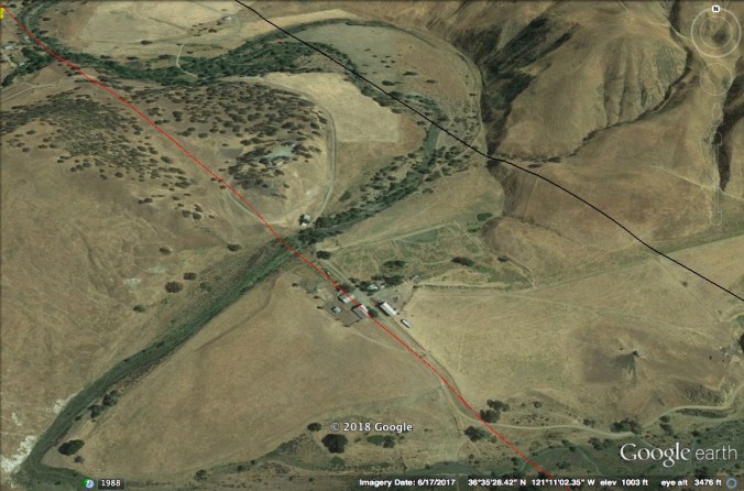
A group of buildings, sitting just to the east of CA 25, is bisected by the San Andreas Fault. The red line marks the fault’s approximate location.
This part of the fault creeps along at a slow rate, maybe an inch per year. When covered by soil and vegetation, the resulting displacement would be nearly invisible on a yearly basis. When we pave the landscape with asphalt or concrete, however, the fault’s movement can manifest itself in ways that are easy to see.
About a ten-minute drive north of Pinnacles National Park’s east entrance the San Andreas Fault crosses CA 25. Here, the San Andreas Fault is slowly tearing the pavement apart.

This is essentially the boundary between the Pacific and North American tectonic plates. Land and water on the fault’s west and south side is moving north relative to the North American continent.

Yours truly straddles the plate boundary between North America and the Pacific.
According to Greg Hayes on his Geotripper blog, this section of road was repaved in 2008. When he visited this site in 2017, the yellow center line paint had not yet split. When I stopped on the morning of January 31, 2018, the paint was clearly cracked.

View is looking north.
This movement has been going on for millions of years. The rocks of Pinnacles National Park, now most famous for scenery and condors, are part of a volcanic field that erupted almost 200 miles to the south. Since then, movement along the San Andreas has displaced the rocks northward, leaving about a third of the volcanic field behind.
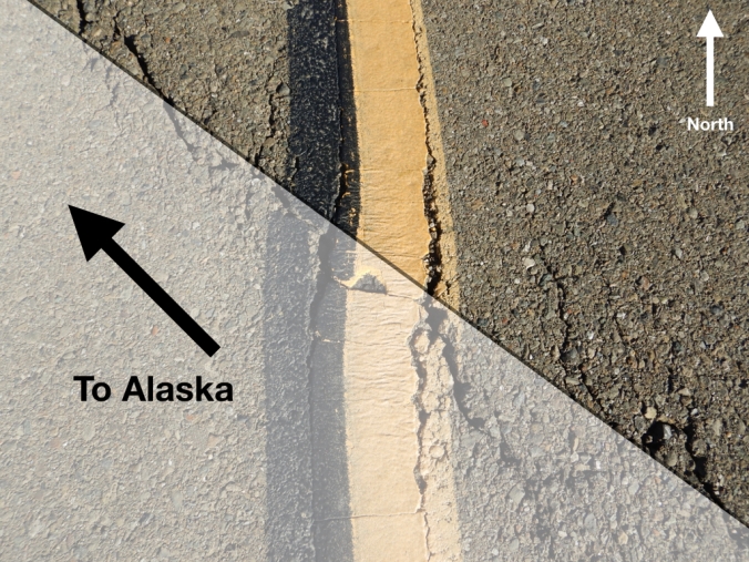
Land on the south and west side of the San Andreas Fault is on track to meet Alaska in a couple hundred million years.
The crack in the pavement is the current surface expression of the fault’s movement. Fault creep is evident elsewhere in California. In Hayward, creep along the Hayward Fault is splitting the city hall in half.
This section of the San Andreas provides a rare opportunity to observe the Earth’s tectonic plates in motion. Because it happens over immense time scales, geologic change is most often undramatic and unnoticed. It happens slowly in rivulets of erosion on a hillside, waves reworking sand on a beach, dust blown in the wind, and creep along faults. As passengers on Earth’s brittle crust, we’re always moving relatively speaking.

You can visit this site on CA 25 at 36°35’54.27″N, 121°11’40.19″W. Please be cautious though; this is a busy highway with a high speed limit. It’s also surrounded by private land, but you can find a couple of small pullouts about a hundred yards from the fault.

Mike I was part of a huge NSF 3 year teacher education program in Earth Science and our last year we traced the southern San Andreas Fault all the way up to Hollister. The Hwy 14 road cut out by Palmdale is something that shows it really well. Also a stop at Mormon Rocks out near the Cajon Pass. Finally going to the famous Wallace Creek offset on the Carrizo Plain . (BTW our first year we traced the Sierras and the volcanoes on their eastern side all the way up to Mammoth Lakes from Bishop.)
LikeLiked by 1 person
How fabulous. What a great project.
LikeLike
So glad to read your article. I’ve missed reading them. It seems like a long time since you’ve posted. This is an excellent visual that makes the fault’s movements real. Almost spring. Where do you plain to be this spring/summer? We leave SC to pick up an RV in Calgary. We’ll have it 3 weeks before dropping it off in Whitehorse. I would really like to go up the new Permafrost Highway and drive to the arctic. Bill would like to go up north of Tok. We’ll see. We have a good bit of time. We’re hoping to take the ferry next year down the Inside Passage to Bellingham. If you have any knowledge you could share about a trip like this let us know. We’d like to spend time in Sitka, Ketchikan, Wrangel, etc. on the way. I’m sure I speak for many when I say I thoroughly enjoy reading your updates. Have a good spring.
Leanne Hopkins A Katmai Bear Krazey charter member.
LikeLike
In March 2013, I took the Alaska State Ferry from Bellingham to Haines (see some photos here), then drove through the Yukon to Tok and southwest to Anchorage. It was very pretty, but I had to get back to King Salmon for work so I didn’t do any sight-seeing on the highways. The ferry ride was very enjoyable though. Be sure to bring binoculars. They’re especially helpful for wildlife watching.
LikeLike
That is pretty cool that you can follow the fault on CA25. Just as long as you are not on the road when the next quake hits! And Greg’s blog is great. Nice to have someone following the fault regularly. I believe it is much better for the fault to continue to slip though. It’s when it binds or slips at different rates that we have a problem. The Hayward Fault is the most worrisome at this point. In addition to a city hall, there are schools and hospitals (and thousands of homes) built directly on or very near the fault and it also crosses the Hetch Hetchy Aqueduct and BART tracks.
If you are heading north, there is an Earthquake Loop trail at Point Reyes National Seashore that highlights the earth movement during the 1906 earthquake. http://resilience.abag.ca.gov/students/fieldtrip-eqtrail/
LikeLike
Thank you for taking us along on your adventures.
LikeLike
Wow, thanks for another great read! Your blog is also a wonderful treat for all of us who are not American and don’t really know all those amazing Parks you guys (still) have – it’s really, really cool to read about them from your personal point of view and then check out all the links you post. Thank you for taking us along on those trips, as someone has already said…
LikeLike