The San Andreas Fault may be the most famous fault on Earth. For roughly 750 miles (1200 km), it creases California and marks part of the tectonic boundary between the North American and Pacific plates. It creates tangible examples for us to see plate tectonics in action.

The San Andreas Fault cleaves the land on the Carrizo plain. Photo courtesy of Ikluft and Wikipedia.
For about 75 miles, California State Route 25 (CA 25) roughly traces the path of the San Andreas Fault as the highway passes through an open valley filled with cattle ranches. (If you’re visiting the east side of Pinnacles National Park, you’ll drive this road.) From the ground, the fault is relatively hidden in most places even though the highway crosses it several times. On Google Earth, it shows a bit more clearly.
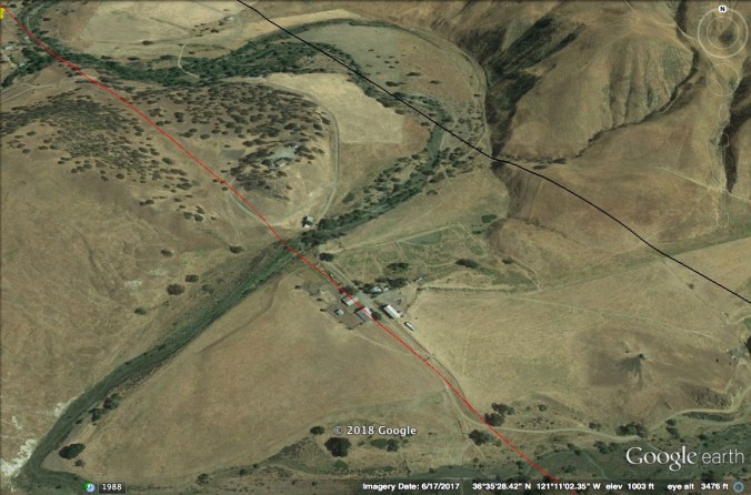
A group of buildings, sitting just to the east of CA 25, is bisected by the San Andreas Fault. The red line marks the fault’s approximate location.
This part of the fault creeps along at a slow rate, maybe an inch per year. When covered by soil and vegetation, the resulting displacement would be nearly invisible on a yearly basis. When we pave the landscape with asphalt or concrete, however, the fault’s movement can manifest itself in ways that are easy to see.
About a ten-minute drive north of Pinnacles National Park’s east entrance the San Andreas Fault crosses CA 25. Here, the San Andreas Fault is slowly tearing the pavement apart.

This is essentially the boundary between the Pacific and North American tectonic plates. Land and water on the fault’s west and south side is moving north relative to the North American continent.

Yours truly straddles the plate boundary between North America and the Pacific.
According to Greg Hayes on his Geotripper blog, this section of road was repaved in 2008. When he visited this site in 2017, the yellow center line paint had not yet split. When I stopped on the morning of January 31, 2018, the paint was clearly cracked.

View is looking north.
This movement has been going on for millions of years. The rocks of Pinnacles National Park, now most famous for scenery and condors, are part of a volcanic field that erupted almost 200 miles to the south. Since then, movement along the San Andreas has displaced the rocks northward, leaving about a third of the volcanic field behind.
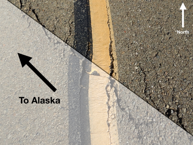
Land on the south and west side of the San Andreas Fault is on track to meet Alaska in a couple hundred million years.
The crack in the pavement is the current surface expression of the fault’s movement. Fault creep is evident elsewhere in California. In Hayward, creep along the Hayward Fault is splitting the city hall in half.
This section of the San Andreas provides a rare opportunity to observe the Earth’s tectonic plates in motion. Because it happens over immense time scales, geologic change is most often undramatic and unnoticed. It happens slowly in rivulets of erosion on a hillside, waves reworking sand on a beach, dust blown in the wind, and creep along faults. As passengers on Earth’s brittle crust, we’re always moving relatively speaking.

You can visit this site on CA 25 at 36°35’54.27″N, 121°11’40.19″W. Please be cautious though; this is a busy highway with a high speed limit. It’s also surrounded by private land, but you can find a couple of small pullouts about a hundred yards from the fault.
