Author’s note: Over ten years ago, I wrote this essay about my cycling experiences at Death Valley. In it you may notice a bias against car travel because I wrote it for a cycling audience in mind, particular those who travel by bicycle. I even pitched it to a cycling magazine (they liked it but needed more quality photos).
I continue to ride my bicycle a lot, and I highly encourage everyone to do so (it’s better for you and the Earth), but over time I’ve come to realize that I should be less judgmental of people who experience parks in different ways than me. Still, I chose not to edit this essay—even though it could certainly use it, especially stylistically. With that being said, here it is, unadulterated and unedited.
I had never been anywhere this windy. I was out for a leisurely overnight trip from Furnace Creek in the heart of Death Valley to the town of Shoshone and back. All went well during this ride—my legs felt strong but worked, I was able to relax, the temperature warmed to a comfortable level (it was December), and I was surrounded the whole way by beautiful scenery. All went well, that is, until the wind hit me like a punch in the face.
Visibility was great earlier that day, and the wind was mostly calm. I could see fifty miles to the north along the wide-open expanse of the valley floor, but there appeared to be a haze obscuring the most distant mountains. My attention was repeatedly drawn back to this haze because it was moving closer. As I rode north, it moved south further obscuring the horizon. By the late afternoon, it was easy to see what was approaching, one of Death Valley’s infamous wind storms.
I’m slow on my bicycle and even more so when it is loaded down with camping gear. The windstorm, if it had any malicious intent, couldn’t have chosen a better time to try and wipe me out. It was late afternoon. I had already ridden sixty miles and my energy levels were dropping. Home was only a dozen or so miles away but the wind forced me to drop into the granny gear. Then it blew even harder. Sand stung my face and dust irritated my eyes. I felt like I was trying to pedal through water. I gave up riding a few miles from home and started to walk.

A dust storm blows across Death Valley.
That day was rough, as were many others, but I always felt compelled to go back out. After all, there was a 3.3 million acre national park surrounding me. In many areas of the United States, the winters may be soaking wet or too cold to bicycle. Occasionally those things can combine to make Death Valley a not-so-fun place to ride. The odds of that happening, however, are very much against it.
It was an easy choice for me to not bring a car to Death Valley National Park, because I don’t own one. I had lived without a car in remote areas of New Mexico and Washington State before, but still I was a little apprehensive about living and working in Death Valley without the ease an automobile would provide (the supermarket lies sixty miles distant from Furnace Creek). It’s not uncommon to read about a car being a “must have” in order to visit and explore Death Valley. For typical national park visitors, this is true. However, I don’t consider touring cyclists to be typical visitors. Without a car, and on a bicycle, is one of the best ways to experience this park.
On average Death Valley is the hottest and driest place in the United States. The books written about it are full of superlatives describing its extreme heat and changes of elevation. The Badwater Basin, elevation -282 feet, is the lowest dry land point in North America. Telescope Peak, the park’s highest point at elevation 11049 feet, looks right down upon Badwater from its western foothold. Temperatures exceeding 120° F are routine anywhere in the valley during the height of summer. The earth’s second hottest temperature ever recorded, 134° F, was measured at Furnace Creek*.
Those are a couple of the most notable features of Death Valley National Park, but during the five months I spent there I discovered that there were many things rewarding to find, and most of those things I would have missed if I hadn’t been riding my bicycle.
I would have missed the level of fitness Death Valley propelled me to. I spent the previous winter and summer in one of the flatter portions of Maine. Cycling there kept me fit, but not like Death Valley. When you’re in the valley, especially at Badwater, there’s only one-way to go—up. The easiest way out of the Death Valley is on a road that climbs over 3000 feet in 20 miles. That’s the pass that I tackled first. From there, the roads became more challenging and exciting. Days riding with 4000 feet and 5000 feet of elevation gain, or more, became common. Whether or not I was loaded up with camping gear or out just for a day ride didn’t matter. The challenge was always there. Over the course of the season, I pounded at the roads daring gravity to slow me down. Of course gravity did its job, but with each passing week my legs became stronger, mountain passes became less daunting, and the return trips down those monster climbs became more rewarding.
That’s something else I would have missed without my bike, the challenge and reward of it all. How far could I safely ride this day or that? What discoveries does that canyon next to the road offer? I found that some days were devoted to cycling, some were devoted to hiking, and some were devoted to both.
I sometimes carried my hiking boots, daypack, lots of water, and trusty bike lock in a couple of panniers. After finding a suitable road sign near a promising destination or hiking route, I would lock my bicycle to the signpost confident that bicycle thieves probably were not perusing the roads. After that, it was just a matter of hiking in.
I wandered to some spectacular places on those days—canyons with waterfalls (yes, even waterfalls can be found in Death Valley if you know where to look), mountain peaks, and the ruins of mining operations gone bust. The lack of daylight during the winter months was limiting however, even more so than my energy levels on some days. I would regretfully leave the mountaintop I reached or the deep canyon I was sheltered in only to be surprised by what I could find while cycling back home.
Without my bicycle, I would’ve missed the surprises that even the ordinary roadsides offered. It was sometimes as simple as being surprised by how different the land looked under different light, how hard cycling can be when you just don’t feel as energized as you wish you were, or sometimes it was just the simple presence of wildflowers that surprised me.
Obviously, Death Valley is a very dry place. Furnace Creek averages less than two inches of rainfall per year. Plant life is not abundant. Occasionally though, winter rains can help produce spectacular flower blooms during the late winter and spring seasons. Unfortunately, this wasn’t one of those winters. Hardly any rain fell, even by Death Valley standards. However, some areas did receive a light rain shower or two. Annual and perennial plants will respond to such things in due time. I must admit, I’m a bit of plant nerd and easily get distracted by things such as roadside wildflowers. Still, it may seem oxymoronic to go to Death Valley to see wildflowers, but in the right place at the right time of the year flowers can appear.
Along a road I pedaled numerous times, light rain had fallen months before. When I came back that way early in March, I was surprised to see the diversity and results of that rain. That day I was sailing down the road on its 6% grade until I noticed the scattering of flowers along the shoulder. I was distracted and surprised enough by them that I barely covered a mile in the next hour. These flowers didn’t produce much along the lines of lushness, but the land no longer felt as desolate as before.
I couldn’t say the same for other areas of the park. “No Services Next 54 Miles.” “No Services Next 72 Miles.” These were some of the road signs I encountered in the Death Valley region. Remoteness and desolation were in no short supply, and that’s part of why people are fascinated with this place. Other than roads, Death Valley has very few developed areas. Yes, there certainly are the typical campgrounds, restaurants, and trinket shops one expects to see in a national park, but the lack of water mercifully limits these services to a very limited number of places. Away from those places, nothing seems to stop the desolation and expansiveness of this place.
The Harrisburg Flats, which the Emigrant Canyon Road crosses, was once the site of a thriving mining community, and like most mining towns in the area it went bust. Now, not much more than rusting tin cans scattered amongst the low shrubs reveal the town’s location. This area, with its evidence of people come and gone and its lack of people today, filled me with the sense that this is about as lonely and desolate of an area as I’ve ever visited.
I cycled up the long haul through Emigrant Canyon for miles and miles to this point with only a handful of automobiles passing by. When I reached the Harrisburg Flats, ten then twenty minutes came and went between cars. I was alone. The old tin cans didn’t offer any company and neither did the northern harrier and the golden eagle I spotted flying nearby. This certainly was a desolate spot, but a blissful one as well. If I had reached this spot in a car after an hour of driving, instead of several hours of pedaling, the emotion of the moment would have been lost. It’s a moment I sometimes think about when streets are crowded and society is noisy.
A lot would be lost without exploring this park on a bicycle. Even the wind added to the experience. The same wind that forced me to walk my bike and flung dirt in my eyes and mouth made plenty of noise. It howled through the edges of the doors and windows of my home. It roared across my ears when I cycled drowning out almost all other sound. But when the wind quit, which it often does (trust me), the silence of Death Valley took over.
During one wonderfully calm day, in the midst of a ride that climbs a vertical mile from Furnace Creek to Dante’s View, I was fortunate to discover just how quiet Death Valley really is. Few cars had passed by me that day in November, which certainly was welcome. However, it wasn’t the lack of cars that I discovered that day. What struck me the most was the immense silence. As I ascended the last few miles to Dante’s View, I only heard two things: the sound of my tires gripping the pavement and my heart pounding in my chest. After I stopped and rested, I didn’t even hear those things.
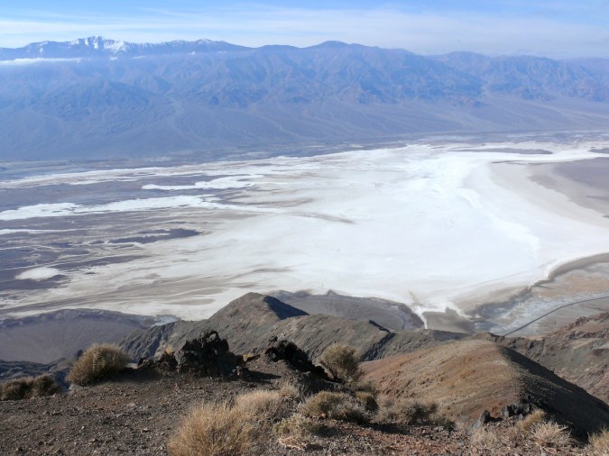
Looking into Death Valley from Dante’s View.
Minus forests, abundant streams, and maybe a conveniently placed bicycle shop, Death Valley offers all a cyclist could want. Ascents of challenging mountain passes, the land’s vast and subtle beauty, the isolation and desolation, the new discoveries, even the wind—it was always these things that brought me back out to ride again. You can even find trees and water if you look for them. Would I have experienced all of these things if I was traveling by automobile? Possibly. Would they have been as fulfilling? Never. The views were never as grand, the flowers never as pretty, and the wind never blew as hard as it did when I was riding my bicycle.
*This is now considered the hottest temperature ever recorded on Earth.


