Vote on Climate

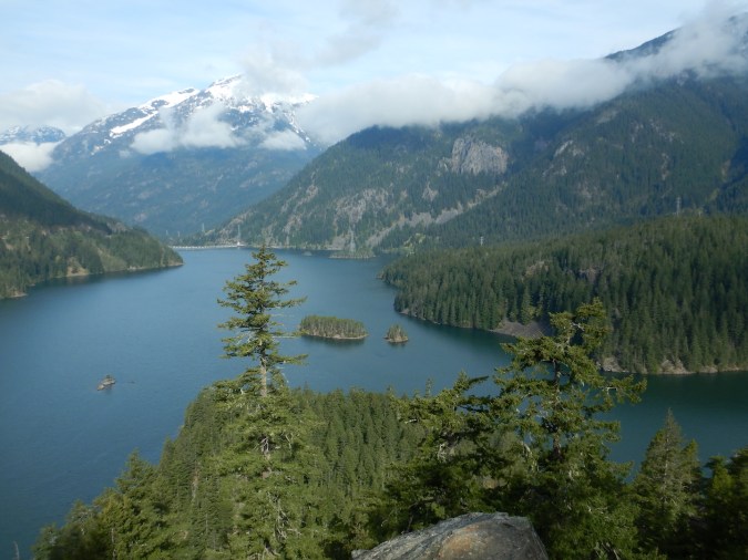
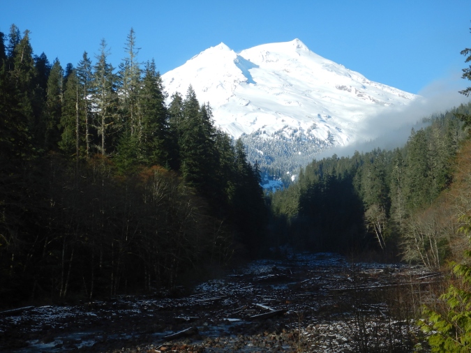
In my last post, I explored the origins of an alpine lake in North Cascades. The news cycle was especially terrible the day I wrote it, so I decided to leave out details about the causes and consequences of glacial retreat in North Cascades. But honestly, the causes and consequences are too great to ignore. It is no small irony that my insight and enjoyment into the formation of an alpine lake was inadvertently provided by people through human-caused climate change.

All glaciers in North Cascades are retreating and they’ve collectively lost over 50% of their mass during the last 100 years. This is directly due to a warming climate, a product of burning fossil fuels like coal and oil.

before and after photos of glacier.

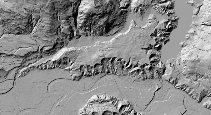
Banded Glacier in 1960 (left) and 2016 (right) in North Cascades National Park.

Unless you’ve been living under one of those glaciers for the past century, you might’ve heard there’s an election next week and voting has begun in many states. While casting our votes, we have an opportunity to elect representatives who will work to mitigate climate change. But, we shouldn’t vote to combat climate change just because glaciers are receding in North Cascades National Park.

We should act on climate, because glacial melt water moderates summertime drought. Millions of people depend on glaciers for drinking water.

We should act on climate to lessen the risk from extreme weather events like drought, hurricanes, floods, and heat waves.

We should act on climate to ensure supplies of fresh water are not overly taxed by humanity’s increasing demands. Who wants reliable access to clean fresh water? All of us.

We should act on climate to help reduce the spread of invasive species, many of which are finding easier footholds where ecosystems are already stressed and fragmented.

We should act on climate to prevent the loss of arctic sea ice, a habitat that helps cool the planet by reflecting sunlight into space, forms the basis of a complex polar food web, and is one necessary for the survival of polar bears.

We should act on climate so coastlines aren’t flooded by sea level rise.

We should act on climate to mitigate ocean acidification, which can impact marine food chains. A lot of us eat seafood and even if we don’t, we like animals that eat seafood (whales, bears, etc.). What would Katmai National Park, my favorite place, be without abundant salmon? An impoverished place, that’s what.

I could go on, but I think you get the point.

We have a moral responsibility to stave off the worst climate change impacts, because this is a human-caused issue. Collectively we can do it, but we have to take the threat seriously. We, as a nation, didn’t vote to combat climate change during the 2016 election. Thankfully, we have another chance now, but time is running out to slow and eventually halt what is one of the most pressing issues facing humanity. That’s why I’m voting for initiatives to mitigate climate change and only for candidates who take climate change seriously.

photo of Washington State ballot showing yes selected for Initiative 1631

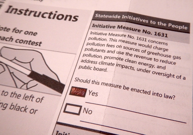
In Washington, Initiative 1631 would authorize the first carbon tax in the U.S. This is my ballot.

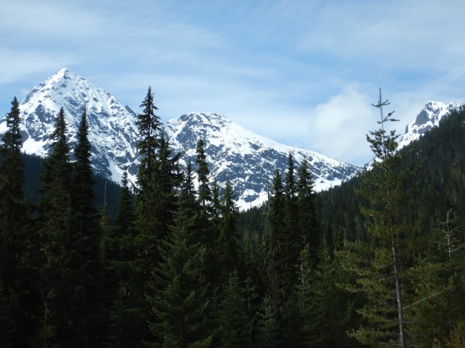
I’ve been fortunate enough in my life to explore active glacial environments in many parts of North America. In Katmai, I’ve walked on pumice-covered glaciers to reach volcanic calderas, numbed my feet in icy glacial runoff, and eaten freshly calved ice (if you’re wondering, it was clean tasting but a little gritty). In the North Cascades I explored the margins of the region’s still active ice. To find an advancing glacier in modern times, however, is rare. Melting glaciers are one of our most conspicuous symbols of global warming.

Glaciers have come and gone in the past, of course. I grew up in a region of Pennsylvania where Ice Age glaciers terminated their last advance, leaving behind eskers and sand quarries. I lived near Lake Chelan, a remarkable inland fjord carved by glaciers. Katmai was also completely overrun by ice. Modern glacial retreat is different though, because we’re the primary cause. Climate change isn’t a hoax or some deep-state conspiracy. It’s real, it’s here, and humans are causing it. There is no scientifically plausible alternative theory that explains the changes to Earth’s climate observed since the Industrial Revolution.

I still find beauty in the ice, but each time I see a glacier I also am reminded of one of Aldo Leopold’s many maxims,

“One of the penalties of an ecological education is that one lives alone in a world of wounds. An ecologist must either harden his shell and make believe that the consequences of science are none of his business, or he must be the doctor who sees the marks of death in a community that believes itself well and does not want to be told otherwise.”

The community is not well, because we’ve wounded it. Let’s step up and act. When you vote, only vote for those who take climate change seriously and, more importantly, will actively work to reduce its impact. The status quo got us here, but the status quo is no longer good enough.

Spring cycling along the North Cascades Highway

Last June, I wrote about cycling to Rainy Pass on the North Cascades Highway. For half the year, however, this road is closed as snow accumulation and avalanche danger, especially, become too great to keep it open. On weekends in spring, when road crews pause their work to clear snow and avalanche debris, the highway opens to bicyclists, so last Friday I took a rare opportunity to ride a car-free road. I found springtime fully fledged at low elevations in the North Cascades and winter’s legacy still holding a firm grip on the high country.

At low elevations, near the town of Newhalem, the weather and vegetation reflect mature springtime conditions. Hummingbirds seek nectar from red-flowering currant, deciduous plants are nearly fully leafed-out, and the ground is snow-free.

pink flowers on shrub

Red-flowering currant (Ribes sanguineum)

Heading east through Ross Lake National Recreation Area, the road climbs most steeply where it skirts the three hydroelectric dams on the Skagit River. Even here, at elevations below 1000 feet, avalanches will sometimes crash across the road when winter conditions are right.

gully on mountainside

In February 2017, a large avalanche crossed the highway at this location, trapping a few dozen people on the other side for several days.

view of avalanche snow on road

An avalanche covering the road at the same place on February 25, 2018. Photo courtesy of Washington State DOT.]

After fifteen miles of riding, beyond Diablo Lake…

View of lake and mountains

…I reached the Ross Dam trailhead where the highway remained closed to cars.

gate across highway. sign reads "Active slide area proceed at your own risk" and "Stop"

Freed of the stress of close encounters with cars, cycling on car-free roads is wonderfully relaxing. Even as I remained reasonably alert for hazards and other cyclists, I was able to do stupid things I’d never try when sharing the road with motor vehicles—like riding down the centerline while recording video.

GIF of road and surrounded by mountains and trees

For me, the car-free environment also promotes stopping where anything catches my attention. Ascending higher into the mountains, I watched as the vegetation became less and less green. From a certain phenological perspective, I was moving backwards through time. By the time I reached 2,500 feet in elevation, most of the raucous birdsong of the Skagit lowlands disappeared and deciduous plants were just breaking bud.

green flowers at the end of a maple branch

Big leaf maple has already finished blooming at low elevations along the Skagit River, but it was still in full flower around 3000 feet in elevation along the highway.

Around highway mile 150, about 15 miles beyond the gate at Ross Dam and 4,000 feet above sea level, snow continuously covered the ground. It only became deeper as I pedaled farther. Just a couple of miles shy of Rainy Pass, where state road crews had halted their work for the week, snow remained five feet deep on the road.

bicycle leaning against snow bank with one lane of plowed highway


bicycle leaning on five-foot high snow bank

The end of the plowed road on May 4, 2018.

As it melts, the snow provides much needed water to streams and rivers in a mountainous region where summer drought is common. For many plants though, the deep snow hinders growth well into summer. On the day of my ride, temperatures hovered in the 60s˚ F, certainly well within the temperature tolerance of plants in the Cascades, but the deep snow keeps the underlying soil cold and dark. Under these conditions, most plants have to lie dormant until growing conditions improve. In the North Cascades, where snow accumulation is so deep and extensive, this set of conditions creates a perpetual spring season on the margins of the snow pack. This gives wildlife like deer and bears the opportunity to eat young and nutritious plants through July and August.

yellow-flowered lily

Yellow avalanche lilies (Erythronium grandiflorum) are currently blooming in the Diablo Lake area. More commonly associated with meadows at higher elevations, these perennials have a short growing season. They begin to grow from a perennial bulb as soon, and sometimes even before, snow cover melts away to take advantage of ephemerally moist soils. By late July, the soils where this specimen grows will have become powdery dry, but at higher elevations this species will still be in flower.

new leaves at the end of small twigs in shaded forest

Late last July, long after I began to feast on blueberries at low elevations, blueberry plants in a snowy portion of Pelton Basin has just begun to leaf out. Late season berries are an important food source for bears this area.

Even during this ride into the middle elevations of the North Cascades (the highest non-volcanic peaks here top out over 9,000 feet tall), it was easy to see how snow exerts a significant influence on the landscape. The week of my ride, road crews reported nine feet of snow at Rainy Pass (el. 4,855’). In a couple of months, when tender plants like yellow avalanche lilies have withered and dried at lower elevations, I can ride up here again and find a microcosm of spring along the edge of the remaining snow.

view of snow-capped mountains and coniferous forest

Burpee Hill

Dry weather has been infrequent in western Washington this fall, so when a clear day dawned earlier this week I couldn’t resist the opportunity to take a wandering bike ride, one of my favorite pastimes. Over the last several years, my bicycle rides and hikes have become far more leisurely since I have become more prone to distraction. Without a fixed agenda though, I’m more open to discovery. Why, for example, would anyone pass on the chance to see a baby snake?

tiny snake in palm of gloved hand

This tiny garter snake was basking on the side of the road on a warm fall day in late October. Concerned it might become road kill, I moved it off of the pavement.

With temperatures near freezing on Monday, I wasn’t going to find any snakes, but over a fifty mile round trip—from Skagit River to the end of the road near Baker Lake—I found more than enough to hold my attention. After a mere two miles of pedaling, I found a reason to pause.

I began at the old concrete silos in Concrete, a small town along the middle reaches of Skagit River…

Concrete silos. Text on silos reads,

Why was Concrete named Concrete? You only get one guess.

Cycling route profile from Google Maps.

No, I didn’t ride the hill as slowly as Google Maps says it will take.

…and immediately began a steep climb up Burpee Hill. In two miles, the road gains over 800 feet of elevation, although I didn’t mind the opportunity to warm up with frost lingering on the grass.

The North Cascades region is the sum of a complex geologic history. Large-scale mountain building, volcanism, and extensive glaciation created and shaped a landscape of unparalleled ruggedness in the Lower 48 states. This area’s geology is, well, complicated. Just take a look at the geologic map.

screen shot of geologic map of Mount Baker and Baker Lake area

Yikes.

On a bicycle, unlike in a car, stopping to check out roadside curiosities—wildlife, road kill, trees, wildflowers, rocks, scenery—is very easy and is an important reason why I enjoy it so much. About half way up the Burpee Hill climb, I stopped to ponder some interesting sediments exposed in a road cut. The coarse to fine grained sediments were well sorted, indicating flowing water had deposited them, and were capped by a mix of unsorted rocks. This is one piece of a grander glacial puzzle.

view of road cut

A few exposures of loose and coarse sediment can be found on the Burpee Hill Road.

Maps that outline the last glacial maximum in North America give the impression that ice flowed largely north to south. While generally true, the story is a bit more complex on a local scale, as Burpee Hill illustrates.

Glaciers are masses of ice that flow and deform, and they behave differently than ice from your freezer. Set an ice cube on a table and strike it with a hammer and it will fracture. Ice in a glacier’s interior, however, is under tremendous pressure. Ice crystals are altered and deformed like plastic putty, so much so that only the upper 30 meters of temperate glaciers are brittle. (The relatively consistent maximum depth of crevasses reveals this fact. Below 30 meters, deforming ice seals any crevasses. Cavities at the base of glaciers have been measured to seal as fast as 25 centimeters per day.) The ice is not impervious to liquid water though. Within temperate glaciers, ice remains at or slightly above freezing, which allows meltwater to percolate to the glacier’s base. Pressure from overlying ice also causes some water to melt at the bed. Once there, meltwater acts as a lubricant helping the glacier slide. These factors, combined with gravity’s pull, drive glaciers along the paths of least resistance, and sometimes these paths lead uphill.

Between 19,000 and 18,000 years ago, a broad lobe of the cordilleran ice sheet invaded the lowlands of Puget Sound. Fingers of the ice sheet reached into the North Cascades as it continued to advance southward. Around 16,000 years ago, the ice sheet reached its maximum extent in western Washington, reaching south beyond Seattle, Tacoma, and Olympia.

On the margin of the ice sheet, lowland valleys like the Skagit offered ice easy passage as it advanced. About 18,000 years ago in the lower and middle reaches of the Skagit valley, ice flowed in the opposite direction of the modern Skagit River. Burpee Hill is largely the result of this process. It’s a 200 meter-thick layer of glacial outwash, glacial lake sediments, and glacial till deposited at the front of ice as it advanced up the Skagit valley. The features are clearer in a LIDAR image.

LIDAR Image

Burpee Hill is the wedge-shaped feature in the center of the image.

LIDAR image with labels. From left to right:

Glacial ice from the Puget Sound area flowed east over the current location of Concrete. The sediments that make Burpee Hill were deposited in front of the advancing ice.

Since its formation, erosion and landslides have eaten away at Burpee Hill, and it is easy to overlook when the lure of craggy peaks and snow-capped volcanoes always dangles ahead. If volcanoes and orogenies are architects of this landscape, then glaciers are certainly its sculptor, reshaping landforms in profound ways. Stories like this are tucked away everywhere. Landforms are rarely ordinary.

Epilogue:
I continued my ride, which (in case you’re wondering) was wonderful even though temperatures remained near freezing. As I expected it to be on week day in early December, the road was quiet. The views of Mount Baker, pockets of old growth forest, and Baker Lake were worth the effort.
view of snow capped volcano and creek valley