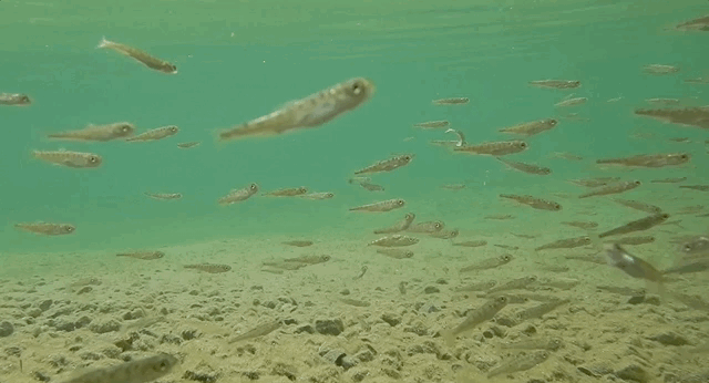
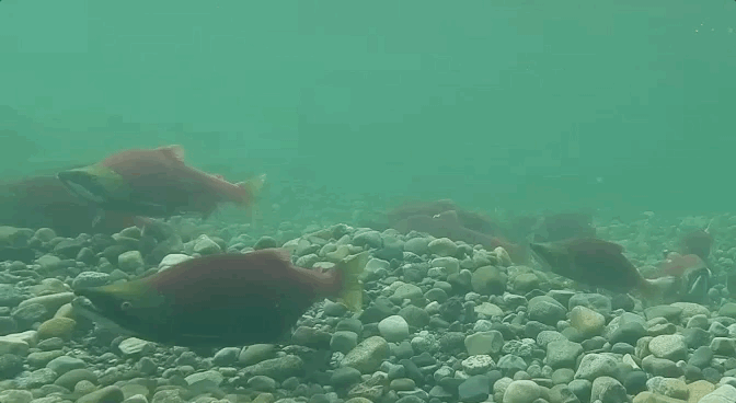
Seventy-nine million salmon returned collectively to Bristol Bay in 2022, setting a new record high for the region. Bristol Bay’s wholly intact watersheds make this possible. Water flows freely from snowmelt-fed rivulets and springs high in the mountains through the chains of lakes that occupy glacially-carved basins and into the lower stems of rivers that empty into the Bering Sea. Adult salmon swim upstream without encountering human-made obstructions or water diversions. And, instead of being displaced by shore-line hardening structures to protect buildings or roads, such as it is throughout much of the U.S. west coast, billions of salmon fry in Bristol Bay find ample refuge in the slack-waters along stream margins, grassy marshes, and lakes. Vast numbers of salmon don’t even see a bridge during their entire lives. The diversity and health of the watersheds make Bristol Bay whole.
I was late to the Pebble fight, only learning about the proposed mine in 2007 during my first summer as a park ranger in Katmai National Park. But many people in the Bristol Bay region have been advocating against Pebble Mine for 20 years. I hope the fishing boat captains and their deck hands; Alaska Native Tribes, village councils, and coalitions; lodge owners, employees, and fishing guides; chefs; scientists; those who work for non-profit and conservation organizations; and many others have the opportunity to rest well for at least a few days now that the threat of the mine is no longer looming. I thank them for their work.
Before I had the fortune of living in the Bristol Bay area, I did not understand—or even fathom—the importance of salmon to place and people. The calendar in Bristol Bay is centered on salmon. The region’s economy is centered on salmon. Its ecology is centered on salmon. And it works, beautifully.
I’ve said many times before that our world is wounded. Too much of humanity seems to have a unique desire and capability to consume land, habitats, material without considering the rights of other creatures or the value that future generations of people might place on those things. I wish I could take everyone to Bristol Bay at the height of the summertime salmon run to see the fishing fleet and processors, to stand on the edge of a river while tens of thousands of salmon swim upstream, to watch brown bears gorge on their most important and sought-after food, to see an ecosystem functioning at its fully realized potential. It just might change your perspective on what should be and what is possible for our world.
Last summer, explore.org celebrated the 10th anniversary of the bear cams at Brooks River in Katmai National Park. These webcams offer an in-depth look at the behavior and ecology of a population of brown bears, allow us to observe the same individual bears over many years–giving us the chance to learn about their personalities and habits–and provide a platform for rangers and other experts to host live programs and commentary about the bears and their stories. It’s a wildlife watching experience like no other.
As part of the celebration, I chose to highlight some the moments that I thought were most memorable from the last ten years of bear cam. Some explore point-in-time events. Others celebrate the behavior of individual bears who have left their mark on Brooks River in ways we can’t forget or ignore. Each was unforgettable from my perspective. I hope you enjoy them.
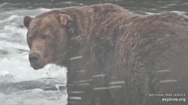
Most Defensive Mother: 128 Grazer
Grazer is an archetypal mother bear. Don’t get in her way and don’t approach her cubs.
Lefty Learns to Fish at Brooks Falls
Old bears can definitely learn new tricks. In July 2015, we watched a fully mature adult male brown bear figure out how to fish where he’d never fished before.
Otis Eats 42 Salmon in a Sitting
Be awed by the capacity of his stomach.
Death of 451’s Spring Cub
When a bear cub falls ill the world will watch.
503’s Saga
A lone yearling finds a new family.
Reign of 856
Few bears will ever experience the prolonged dominance and advantage earned by 856.
2020 Salmon Smorgasbord
What happens when bears have access to unlimited salmon? The 2020 salmon run gave us the answer.
History of Fat Bear Week
A goofy idea becomes a world famous internet sensation.
We are Family: 909, 910, and Cubs
Sister bears reunite while raising cubs to create an extended family.
If that’s not enough, the bear cam community complied links to all of our bear cam live events from 2022. Two stand out in my mind: 1. The impromptu Q&A about a fight between and mother bear and a dominant male, and 2. The bear cam 10th anniversary live chat.
We’ve seen a lot of special moments on the cams during the last ten summers–perhaps too many to recall–so these are only a small snippet of the larger story. What are your most memorable moments from the bear cams?
I find the urge to explore bogs and boggy habitats difficult to resist. Other people avoid them, which gives me space to be alone. They’re mucky, which is often a fun and challenging substrate underfoot. They contain unique species, which I find fascinating. They are full of life. And they offer surprises.
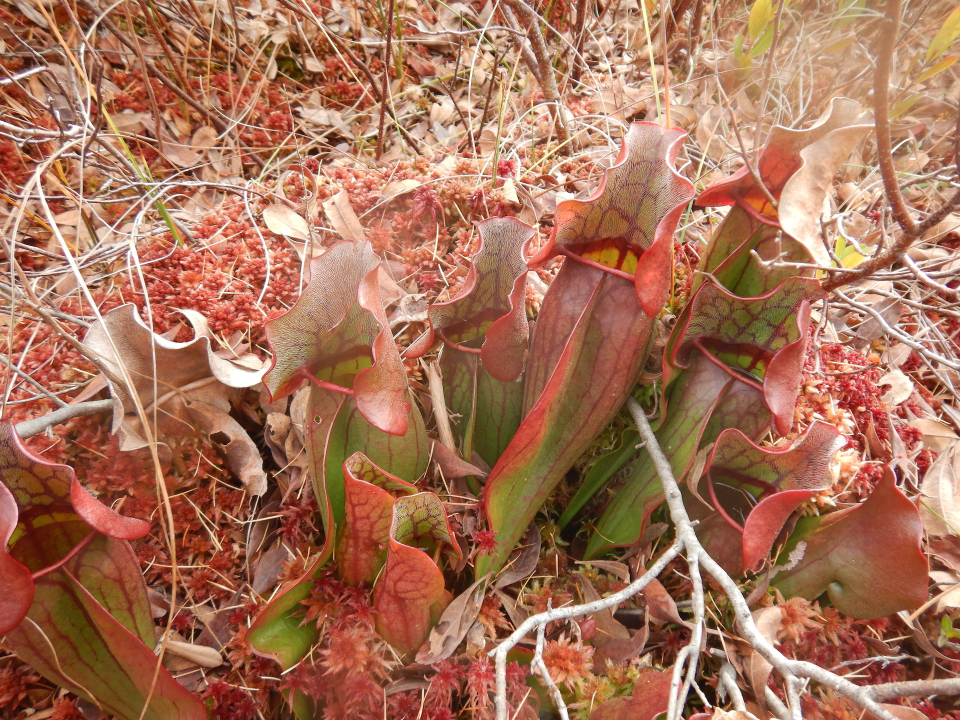
On an unseasonably warm late October day, I found myself poking around the edges of Little Messer Pond, an approximately 27-acre pond in Katahdin Woods and Waters National Monument, Maine.
Little Messer PondLittle Messer Pond
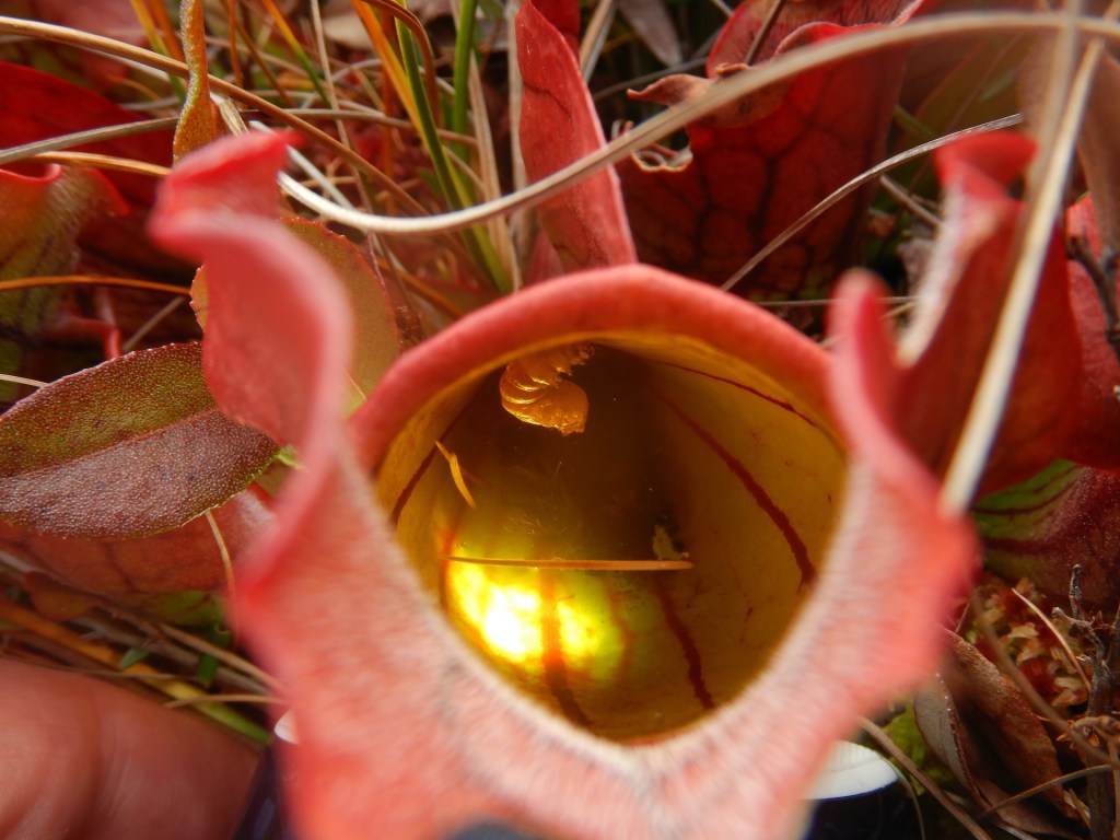
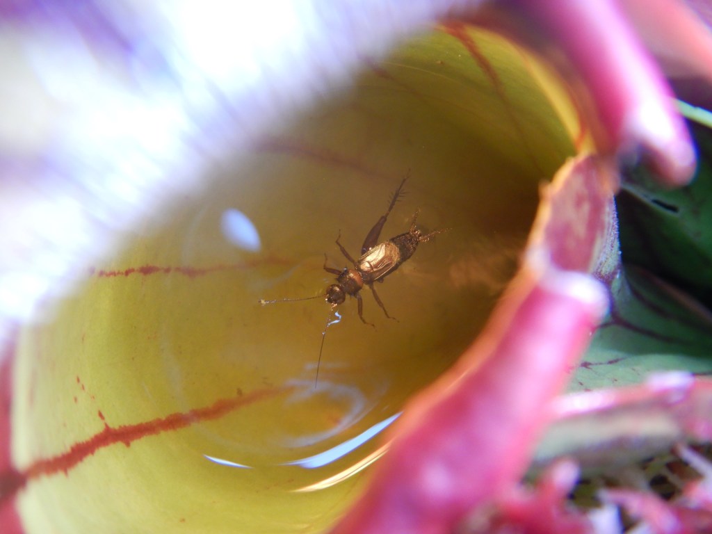
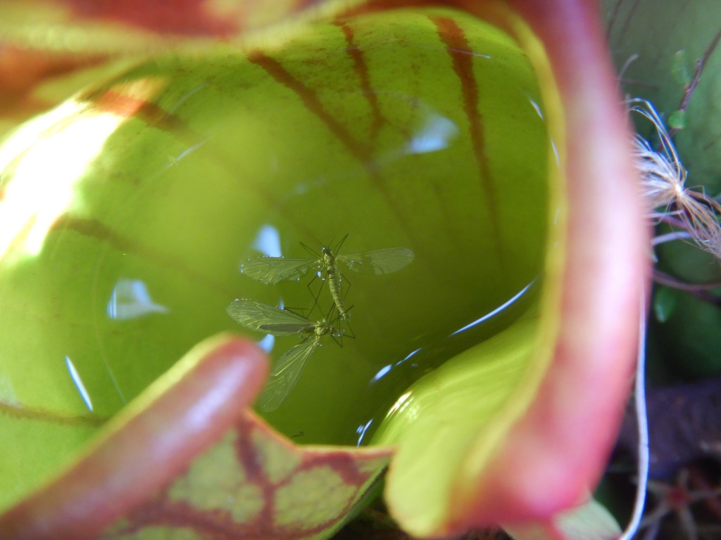
While exploring the pond’s northern flank, on a shelf of sphagnum peat that cups the pond’s shore, I found several purple pitcher plants (Sarracenia purpurea), one of the most iconic bog species in this area. The purple pitcher lives an uncommon, carnivorous lifestyle for a photosynthesizing organism. Pitcher plants supplement their growth by capturing small animal prey, typically insects. Unlike Venus fly-traps, however, which ensnare prey using a trigger-like mechanism, pitcher plants use a passive, gravity-driven process. Their leaves form bell or cone-shaped bowls that fill with rainwater. The top of the each leaf has a flaring lip lined with nectar glands to attract insects. If a hapless insect falls inside, downward pointing hairs resist its escape attempts.
Purple Pitcher Plant
Pitcher plants can’t move, so they have unsurprisingly indiscriminate tastes. To cite just one example, a study from Newfoundland documented 12 insect orders serving as prey in pitcher plants. Prey eventually drowns in the pitcher’s water where enzymes as well as inquilines (microorganisms adapted to live in the pitchers such as midge larvae, nematodes, bacteria, protozoa, and rotifers among others) break down the trapped prey, releasing nitrogen and phosphorus for the plant. Purple pitcher plants, in particular, seem to be particularly rich in inquilines, hosting at least 165 different species across its range. Pitchers are habitats of their own making and their adaptations allow them to live in nutrient poor soils where competition from tall plants in minimal.
Looking at the pitchers on the edge of Little Messer, I found ants, beetles, flies, dragonflies, various bits of unidentified insects, and a sludge of the leftovers in their bowls.
They’d eat me if I were small enough.
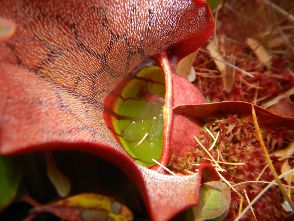
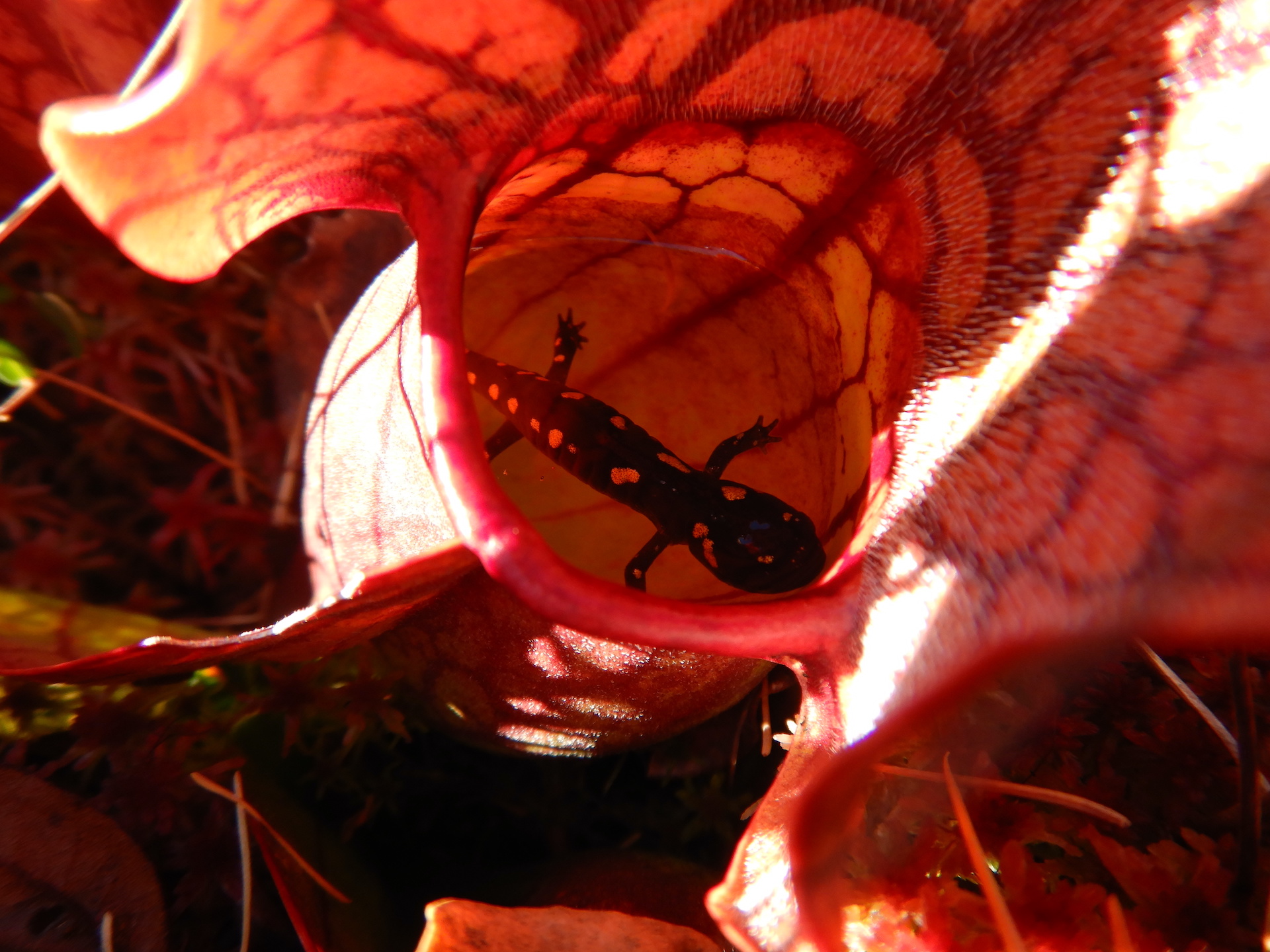
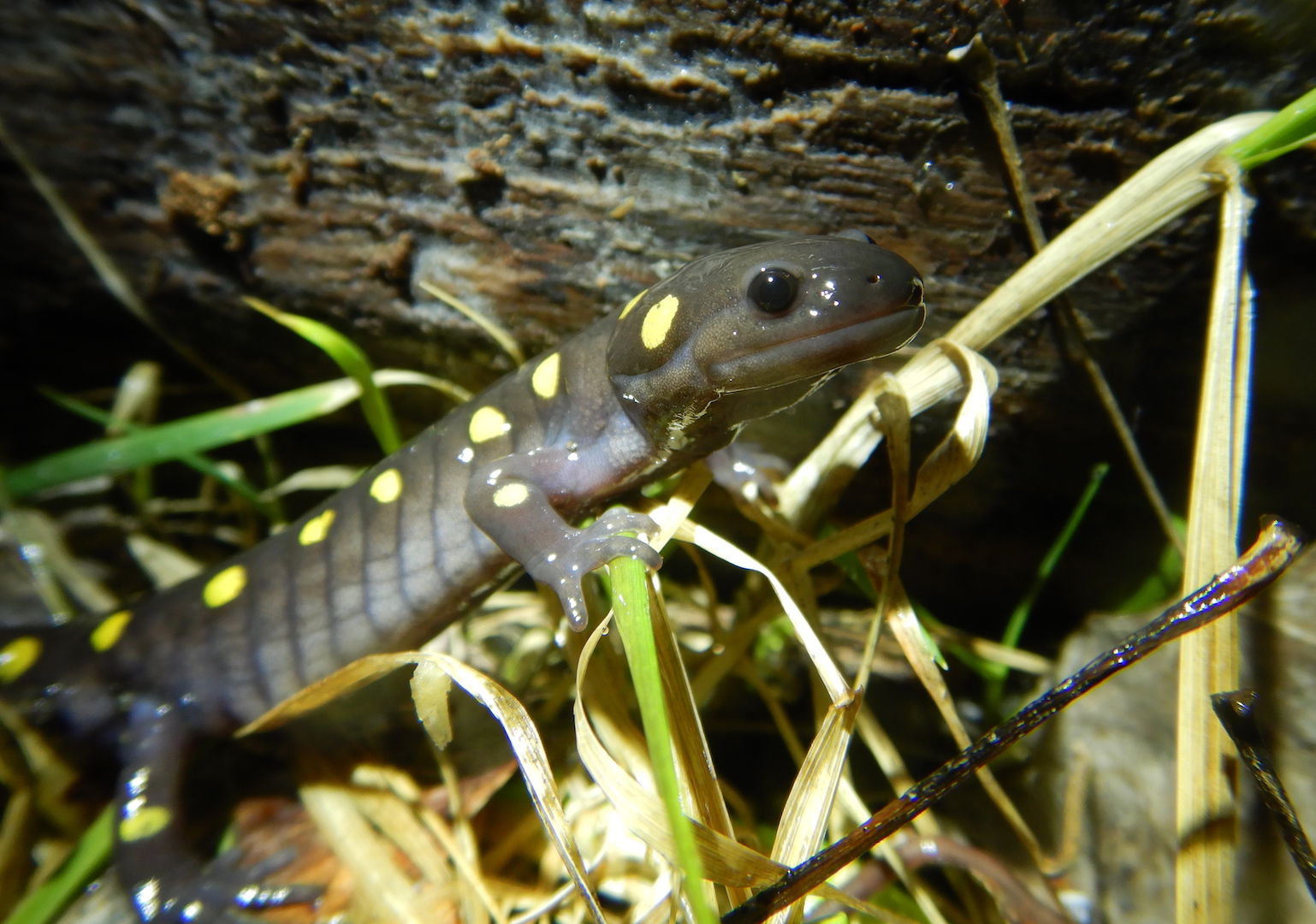
None of the prey was unusual or unexpected until I stumbled upon a curious sight—a spotted salamander inside a pitcher.
I was taken aback by the sight. I had never seen something like this before, and I remember exclaiming “What the?” even though I was alone. Was this a big payday for the plant or was the salamander only a temporary resident?
Small vertebrates are exceedingly scarce as a prey item for purple pitcher plants. In the scientific literature, I couldn’t find much documentation of it. A study from Massachusetts documented red-spotted newts as a food source for pitcher plants. A more recent study from an Ontario bog found that spotted salamanders are a potentially rich prey for pitcher plants. (One of the researchers leading that study described his sighting of a salamander in a pitcher plant felt like a “WTF moment” so I guess I wasn’t alone in my surprise.) In August 2017, researchers at that study site searched the contents of 144 pitcher plants. They found, as expected, mostly insects but also several recently metamorphosed spotted salamanders. In August 2018, they investigated 58 plants and found three spotted salamanders. The physical condition of the salamanders varied. Some were in an advanced state of decay while others were lively and were able to swim to the bottom of the pitcher when disturbed.
Plenty of uncertainty surrounds pitcher plants and the importance of small vertebrate prey to them like salamanders and newts. No one has yet tested what might attract a salamander into a pitcher since a salamander has to climb up to get into one. If the salamander can escape, then pitchers could be a refuge for salamanders who have recently emerged from the water onto the land. Perhaps salamanders are attracted to the pitcher by small insects visiting to feed on the plant’s nectaries. Their apparent capture could be random too, although, dead salamanders apparently break down quickly inside pitcher plants so maybe their true rate of capture is greater than anyone realizes.
I wonder if it might happen only in places with the right combination of habitats. Purple pitcher plants typically (but not exclusively) grow in nutrient poor bogs, places that don’t always support breeding populations of spotted salamanders. Adult spotted salamanders migrate en masse during spring to vernal pools where they breed. They may also use permanent ponds for reproduction as long as those don’t contain fish, which eat salamander eggs and larval salamanders. Newts, in contrast, breed in a greater variety of wetlands including ponds and lakes that contain fish.
At the Ontario study site, pitcher plants grow on bog islands in permanent and fish free ponds where spotted salamanders gather to breed every spring. This seems to provide a combination of habitats that increase the likelihood of pitcher plants capturing salamanders later in the year when the juvenile salamanders metamorphose and begin their terrestrial lives. Little Messer Pond, in contrast, is home to fish, snapping turtles, and presumably other salamander predators.
A salamander or newt, even a juvenile, is a significant catch for a pitcher plant. A newt of about 500 mg of dry mass contains about 5 mg of nitrogen, which is several orders of magnitude more than an ant, a pitcher’s most common prey. That’s enough nitrogen to increase the probability of the plant flowering the next summer. If the salamander I saw had indeed perished in the pitcher, maybe it’ll dignified in death by a marvelous pitcher plant flower next summer.
In my area, purple pitcher plants flowers appear in early summer.
Pitcher plants are wonderfully adapted to secure nutrients and survive in habitats that most plants cannot tolerate. If they’re lucky enough to capture something as large and nutrient rich as a salamander, then their physical structure can hinder escape. Their acidic water (often lower than pH 4 by mid summer) can weaken salamanders through electrolyte imbalance. And, the water within them might contain compounds that inebriate or paralyze small prey.
The fate of the salamander that I found remains unknown. I returned a week later with the intention of relocating it, but I could not find it despite my best efforts. Although I can’t be sure, I think it is unlikely that I missed it since the boggy area with the pitcher plants isn’t large and the pitchers are easy to locate. If it were still alive, perhaps it fled to the bottom of the pitcher upon my approach. However, if it were still in the pitcher after seven days, then it should’ve been dead. Did it escape the trap that so many other victims of pitcher plants could not? I wish I knew the end of this story—a drama of uncertainty, survival, life, and death.
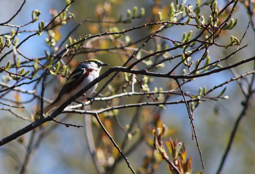
In the northern third of Maine spring weather is fitful, and I sometimes wonder if winter will ever break its hold. Eventually, though, usually in mid March, snow cover begins to thin as the sun travels higher in the sky and daylight hours lengthen. Around this time, maple sap runs heavy. As April arrives the hazelnut, speckled alder, and aspen (or “popples” as they are locally called) break bud as the ground thaws in earnest. I might see my first dark-eyed junco of the year about that time, followed by flickers and sapsuckers who drum from the trees as they establish nesting territories. Wood frogs, spring peepers, and salamanders wake from hibernation and migrate to their breeding pools on rainy nights. The warblers return in May along with early ephemeral wildflowers and the first expanding tree leaves in the canopy.
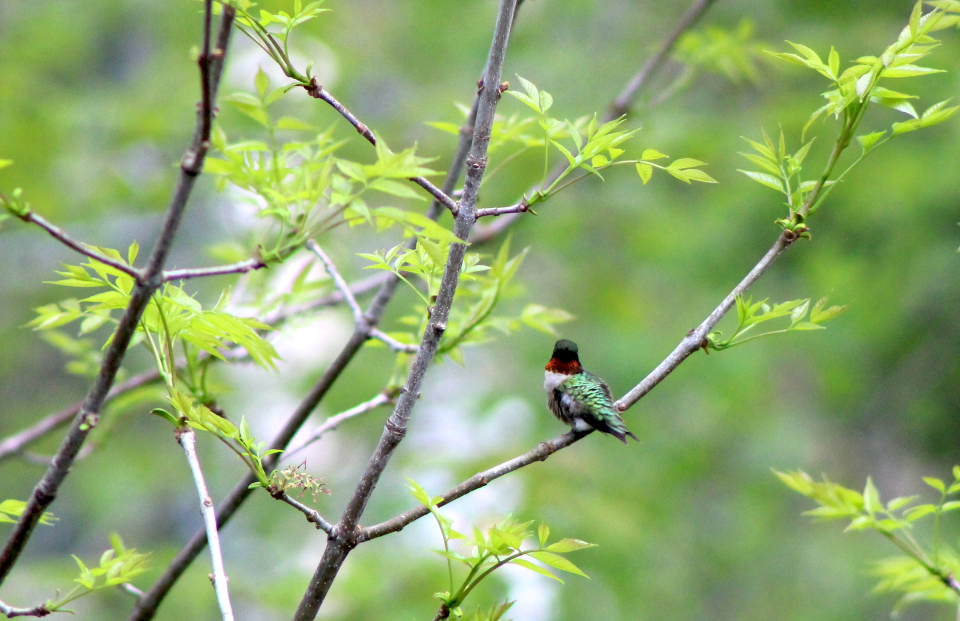
Although I welcome these changes like a reunion with friends, there’s one event beyond any other (even the appearance of biting insects), that to me signals the full arrival of spring—the return of hummingbirds.
A male ruby-throated hummingbird.
On May 12, I was treated to the first hummingbirds of the year at my feeders. Only one hummingbird species, the ruby-throated, nests in the northeast U.S. and southeastern Canada. The ruby-throats that establish summer residency near me may have migrated from wintering areas in Central America, probably by flying over the Gulf of Mexico before making their way farther north.
With a heart that pounds at several hundred beats per minute and wings that buzz at a too-fast-to-see pace, an active hummingbird is a powerful metabolic furnace. While insects and spiders are important foods, the fat and protein the bird ingests from invertebrate prey goes only so far in its effort to sustain their exceptionally high metabolism and energy-intensive flight. An active hummingbird’s metabolism is so high that it must eat about half its body weight in sugar each day, and it digests sugar so rapidly that it essentially refuels in flight.
The energetic costs of this lifestyle are great, so if you are a tiny bird that weighs only a few grams then it pays to be as efficient in your nectar gathering as possible. For a hummingbird, the process begins with an ingenious adaptation of the tongue.
Scientists long assumed that hummingbirds utilized the passive work of capillary action to drink nectar—stick your tongue into a flower, contact nectar with it, and allow the liquid’s surface tension to coat the tongue. However, in a 2011 paper published in the Proceedings of the National Academy of Science,* Alejandro Rico-Guevara and Margaret Rubega discovered that that a hummingbird tongue works in a much more efficient manner.
A hummingbird’s tongue is forked, somewhat tubular, and supported by stiff rods. That anatomy has been known for quite some time, but Rico-Guevara and Rubega found that the tongue utilizes no capillary action. Instead it is a shape shifter, a fluid trap, and in the author’s words, “a dynamic liquid trapping device.”
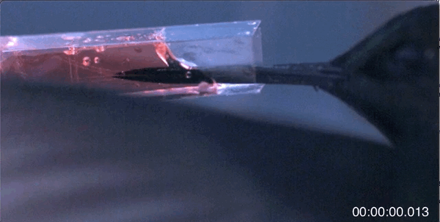
As the bird sticks its tongue out the tips remain adhered together. At this point, it looks like a long pin. Once the tongue contacts nectar, though, the real magic of the tongue’s anatomy begins its work. First, the tongue splits as curved lamellae (parallel hair like structures) along the tongue tips unfurl in the liquid.
In nectar, a hummingbird’s unrolled tongue tips substantially increase the surface area in contact with the nectar. Timestamp is in milliseconds. Movie SM01 from (2011) Rico-Guevara and Rubega.
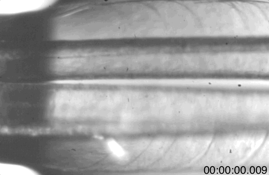
As the bird retracts its tongue, the lamellae re-furl over the supporting rods and trap a tube of nectar inside each tongue tip.
A view of a hummingbird’s tongue re-furling as it is withdrawn from nectar. Air is on the left. Liquid is on the right. Timestamp is in milliseconds. Movie SM03 from (2011) Rico-Guevara and Rubega.A closer view of the tongue re-furling. Air is on the left. Liquid is on the right. Timestamp is in milliseconds. Movie SM04 from (2011) Rico-Guevara and Rubega.
Amazingly, the tongue’s transformation and liquid trapping properties are driven not by muscles, but by fluid and gaseous forces acting directly on the tongue. The tongue’s structure is hydrophilic, so when the tongue contacts air the lamellae curl around the nectar and traps it inside. The bird releases the nectar by squeezing and slightly flattening the tongue as it is pulled into the bill.
Nectar can be a difficult to access food. Hummingbirds exploit it like no other bird because they can hover in flight and, as a group, have diverse beak lengths and curvatures to probe flowers of different sizes and shapes. They are also clever enough to trapline—that is, they’ll visit the same food sources like patches of flowers on a regular basis to minimize competition and maximize nectar availability.
But knowing how specialized the hummingbird’s tongue is, I’ll never look at a feeding hummingbird the same way. The hummingbird tongue, long thought to be a passive part of the process, is a superb adaption that plays no small role in helping these tiny birds live a large life.
*The paper is a fascinating bit of natural history and is open-access, so I encourage you to read if you want to learn more about this topic.
Bird Week 2022 on explore.org has come and gone, but if you missed it I hosted a series of live events to celebrate birds and learn more about their amazing lives.
I thank the crew at explore.org for helping to produce Bird Week and showcase these wonderful and amazing creatures. I hope you’ve had an opportunity to enjoy some time watching our feathered neighbors. If not, do yourself a favor and make the effort. Even the most common and overlooked birds have incredible stories to tell.
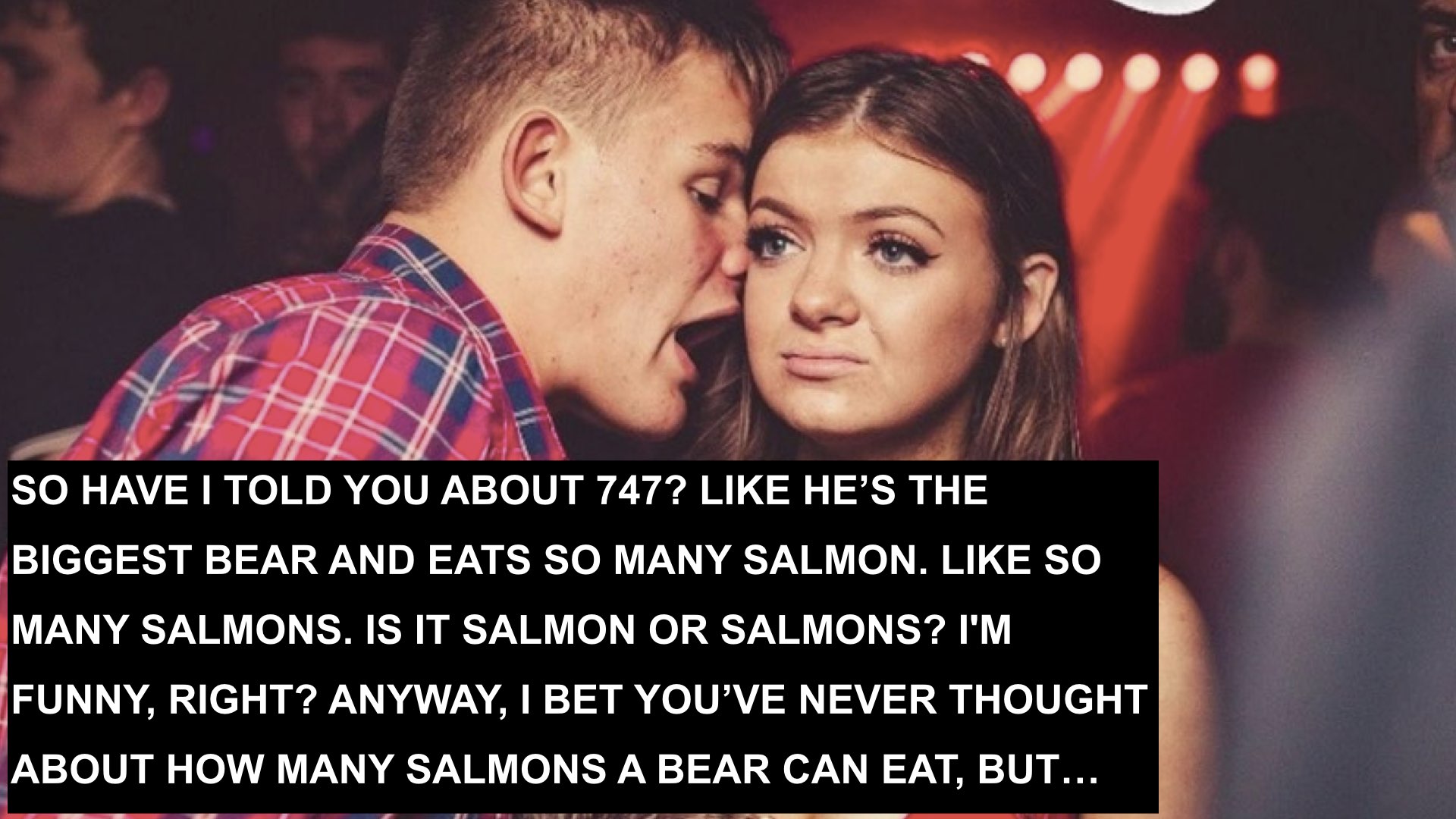
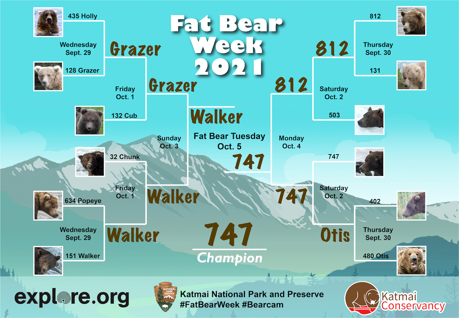
Life as a champ is rough. Rivals look to take advantage of any weakness you might show. Arm chair critics analyze your every move. Fans expect perfection. When the next championship tournament rolls into town your body has aged another year and your preferred food has worked its hardest to evade and escape you. Meanwhile, you’re trying to live your best life, because you are a bear and the concerns of humans matter not to you.
Yet, for those of us who recognize greatness and celebrate success when we see it, there is one clear choice for Fat Bear Week 2021—the mighty 747.
Long-time readers of this blog may be thinking, “This again?”
…Let me tell you dear friends: 747 is as fat as ever. He deserves your Fat Bear Week vote.
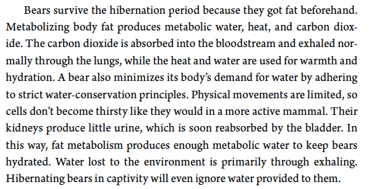
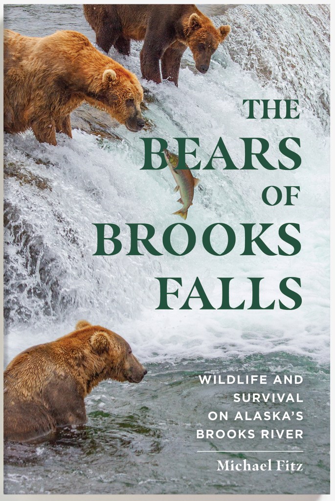
Brown bears get fat to survive. Their obesity (and it is that since a bear’s body fat percentage is routinely 20-30 percent or more when they begin hibernation) is a savings account. In the den, bears do not eat or drink. They stay warm and hydrated by burning body fat. Unlike utilizing muscle for energy—a process that produces metabolic wastes that must be recycled, sequestered, or purged from the body—burning fat is a relatively clean fuel as I write in chapter 4 of my book, The Bears of Brooks Falls.
It’s akin to cultivating mass only to carefully harvest it later. Just not for vanity’s sake, bro.
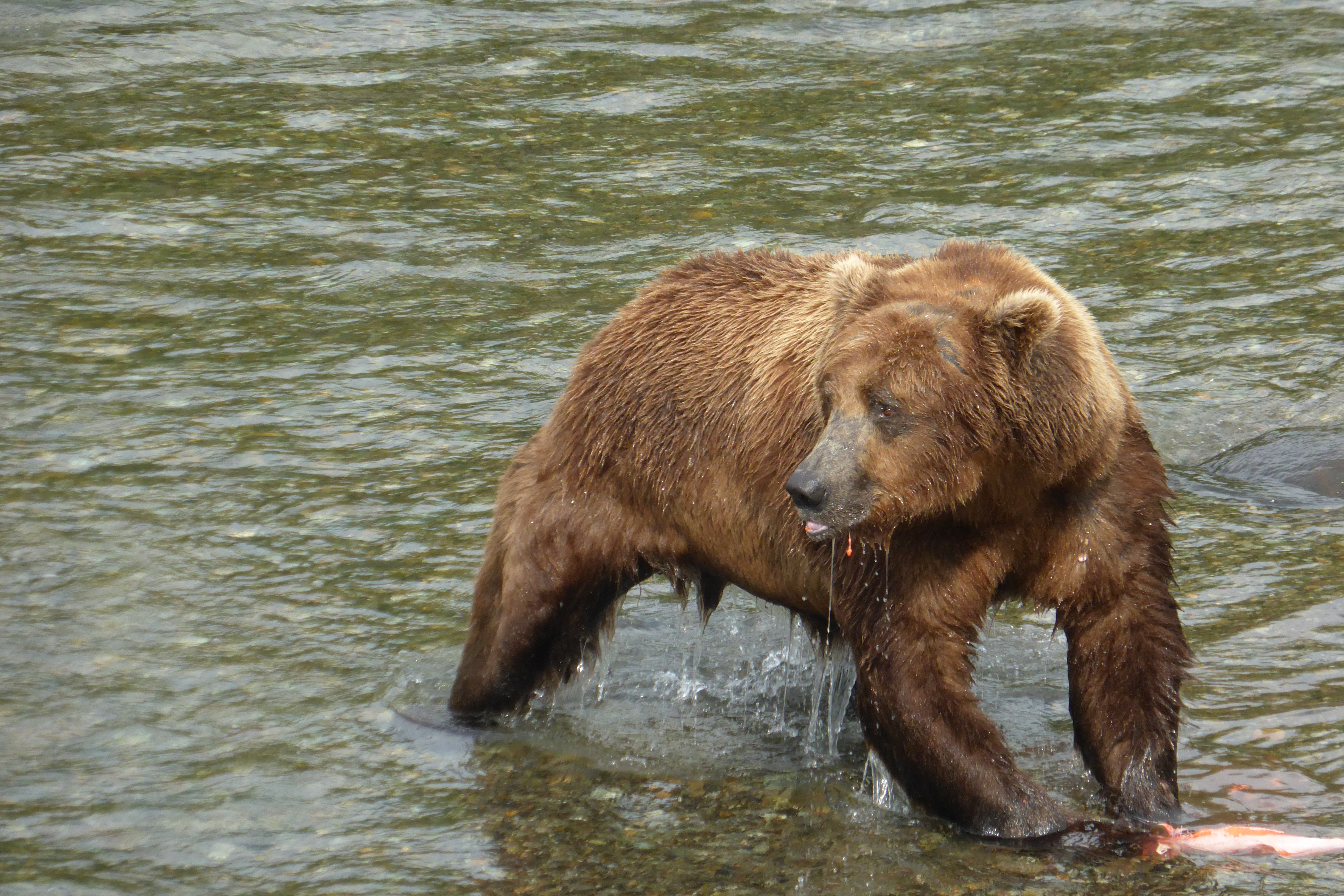
747 cultivates mass at an exceptional rate. This summer, he reigned as Brooks River’s most dominant adult male. Even the river’s long-time dominant bear, 856, would not challenge him, and as a result 747 had nearly free access to any fishing spot of his desire.
A single brown bear can eat thousands of pounds of salmon per year. The largest can eat 6,000 to 10,000 pounds. Given his size, appetite, high rank in the bear hierarchy, and his keen fishing skills, 747 is more than capable of eating many thousands of pounds of salmon each summer. At Brooks Falls, he intercepts a great deal of fish by being at the right place at the right time and waiting for his food to come to him. When Brooks River’s sockeye migrated upstream, 747 was primed to harvest them.
He’s so successful that in September 2019 and again in September 2020, he was estimated to weigh more than 1,400 pounds. This places him, as I estimate, among the top one percent of brown bears based on body mass.
Even with his size, he remains agile.
747 reminds Grazer and cubs that he's still a dominant big boy at Brooks Falls. pic.twitter.com/mNNNF3OD66
And yes, that is a tapeworm hanging on for a ride.
Fat Bear Week celebrates the success of Brooks River’s bears, the ecosystem and salmon that sustain them, and the bears’ abilities to get fat and survive. 747 exemplifies success among adult male brown bears. He deserves your vote and a repeat Fat Bear Week victory.
Bearcam is back for 2021, and while it’s still very early in the season several bears—including Grazer, Holly, and their yearlings—have made an appearance. As Rangers Naomi Boak and Lian Law discussed with me during our Welcome to Bearcam live chat, there are many fascinating storylines to follow this year. At the risk of offering a shameless plug, my book, The Bears of Brooks Falls, explores many of those stories too.
A dedicated book club has sprung up to discuss the book. At the end of each meeting, participants answer one question: If you could ask the author anything, what would be? Below, I’m happy to answer those questions. If you are interested in joining the book club for their next discussion on June 19 via Zoom, please sign up.
Questions from the club’s discussion of Part One: Creation and Discovery (May 29, 2021)
Can you clarify WHY there used to be fewer bears at the falls? In the past, were they hazed away? Did they stay away from the falls because anglers were given priority there?
In Part One of my book, I discuss the events that led to the proclamation of Katmai National Monument in 1918 and the monument’s evolution into one of the largest national parks in the United States. Bears were not a major tourist attraction at Brooks River until long after Brooks Lodge was established. It wasn’t because anglers were given priority. It was because the bear population was much smaller than today. The national monument was expanded in 1931 to include areas such as Brooks River to protect habitat for wildlife like bears, but:
By all accounts, few bears used the river when Brooks Lodge first opened for business in 1950. Bears and any type of bear-management activities were absent from the reports of the first rangers stationed at Brooks Camp. Ranger Russell Todd, for example, never saw a bear on foot in the summer of 1954. The presence of people alone was apparently enough of a deterrent to displace bears from the river except at night. In 1957, biologists conducting salmon research at Brooks River for the US Fish and Wildlife Service reported bears “loudly evident” every night during September at the salmon- counting weir strung across the head of the river.
How many bears lived within the monument at that time remains an open question, but it was likely not many. The population may even have been at a nadir, the result of decades of heavy hunting pressure near the monument and, I suspect, the lingering effects of the 1912 eruption. After a two- summer biological investigation of the monument in 1953 and 1954, Victor Cahalane reported: “It is impossible to make even a rough estimate of the population of bears in Katmai National Monument.” Yet he tried. According to his and other anecdotal sightings, including one from a pilot who claimed to have seen 60 bears along Savonoski River in early September 1954, Cahalane ventured that about 200 bears lived in the monument.
Steady levels of salmon and a reduction in hunting pressure outside the monument were probably the main factors that allowed the area’s bear population to slowly increase, but at Brooks Camp people inadvertently helped accelerate the bears’ use of the river. By the end of the 1960s, a small and growing contingent of bears had become accustomed to the easy access to unsecured food at nearby garbage dumps, the lodge’s burn barrels, and unsecured supplies. By the mid- 1970s, Brooks Camp had become well known as a place to find at least a few bears, and several had begun to fish in the river during the day when people were active. (Pg. 172-173, The Bears of Brooks Falls)
I will add that over the last 40 years, salmon runs in the Naknek River watershed have been quite strong and that, perhaps more than anything else, has allowed the bear population to increase in the park. Additionally, during much of that time, park staff management have emphasized minimizing bear-human conflicts. The experience of cubs that accompanied their mothers to Brooks River may now consist largely of relatively benign contacts with people. This probably allowed the number and proportion of adult bears tolerant of people to increase.
It sounds, from Mike’s description [in Chapter 3 — Ramble], that the outlet of Brooks Lake into Brooks River is pretty shallow. Could global warming threaten the snowfall on the mountains, dropping the level of the lake and halting the flow of the river? If so, could that be a risk in the near future?
Although I can only provide a speculative answer, and while Lake Brooks will be affected by a warmer atmosphere, its water flow may not change appreciably. Lake Brooks occupies a deep basin that is almost completely below the water table of the surrounding land. There are no glaciers in its headwaters, unlike nearby Naknek Lake, so it’s already adapted in a sense to a hydrology that is highly influenced by annual precipitation. Snowmelt is only one influence. After most of the snow melts from the watershed in late spring, then summertime rain seems to have the biggest influence on water levels in the lake. Wetter summers can raise lake levels more than a foot compared to dry summers. Importantly, much of its water is sourced from spring-fed streams and springs under the lake surface. So, even during drought years, the lake basin experiences some recharge.
Climate change is certainly altering Katmai’s landscape, both the land and water. In 2019, we saw the impacts of a very hot, dry summer on Brooks River. Water levels were quite low and water temperatures were quite hot during an early July heat wave that year. However, water continued to flow through the river, albeit at a reduced level.. That’s just one year, though. By the end of the century—especially if we don’t get our act together and reduce our greenhouse gas emissions as quickly as possible—the summer of 2019 will be one of the coolest of this century. Droughts and heat waves may become the norm in Katmai. For more information on the present and future of Katmai’s climate, please see chapter 17 of The Bears of Brooks Falls.
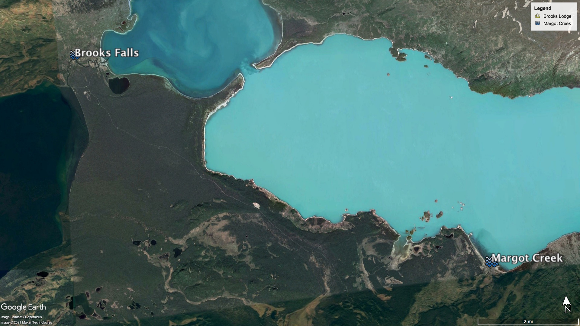
Can you clarify the distance from Brooks River to Margot Creek? Is it common — or uncommon — to see “our” cam bears at Margot Creek?
The shoreline of Naknek Lake between Brooks River and Margot Creek is about 13 miles, well within a day’s walk for a brown bear. If a bear takes a few shortcuts through the forest, then the walk is closer to 10-12 miles.
Several identifiable Brooks River bears use Margot Creek in August including 402, 435 Holly, 480 Otis, and 856. I would not be surprised if there are others well. But, salmon are dispersed widely in central Katmai in August when bears fish at Margot Creek. Unlike early summer and early fall when Brooks River is the only place to fish, bears have many other alternatives to Margot Creek in mid summer so not all Brooks River bears need to go there.
Can you talk about your research process? The book draws on your personal experience — but it clearly draws on extensive research, too.
When I began drafting the manuscript, I thought most of my research was finished since I had to study a lot to prepare programs and talk about bears when I was a park ranger at Katmai and through my current job at explore.org. That head start was helpful but not thorough enough. It was merely the foundation to build upon.
As I wrote, I wanted to be sure that my facts and conclusions were backed up by personal observations, experience, and the best available science. While working on the manuscript, I probably spent half my time reading research and half my time writing.
I began writing each chapter by outlining it. Then after I established what I wanted to write about and the stories that would add depth to the facts, I read or skimmed through the relevant books and scientific papers that I saved previously to establish the basic facts that I wanted to include and confirm what I thought I knew. This led me down many rabbit holes. I probably read dozens of papers for some chapters, especially Chapter 4 on hibernation. Tracking down specific facts and, hopefully, ensuring that I represented them accurately in the book was a tedious yet necessary task. Readers deserve no less.
Not a bear question, but a question for you as an author: What did it hurt to leave out of the book? What did you have to omit that you wish you’d been able to keep?
Quite a lot, actually. For example, I drafted chapters on glaciation and the evolution of Brooks River, but after consulting with an editor I decided to cut those. They weren’t a great fit for the narrative I tried to build. I also wanted to include the story of Holly adopting a yearling 503 in 2014 but couldn’t find the right place for it when I outlined the book. I considered using that story as the framework for Chapter 5: Family, but since adoption in bears is so uncommon I thought it best to focus on a bear whose maternal experiences were engaging yet more typical. That’s how I settled on 273 and her cub for Chapter 5. I’m happy with the final result of that chapter, yet I still wish I had found a way for Holly to be a part of it.
Questions from the club’s discussion of Chapter 6: Mating Season (June 6, 2021)
What if a female [bear] doesn’t want to mate? How much “say” does she have in the decision?
The female bear can’t control estrus or the signals that indicate to males that she is in estrus. However, female bears seem to have a lot of say in the timing of copulation. Although male bears are much larger than females, I’ve never seen a male bear force himself on a female bear. Instead, he doggedly follows her until she is ready to accept his advances. I also wonder if prolonged courtship can provide female bears with the chance to shed a suitor that they do not prefer. As I write in the book, a bear’s sense of smell is so powerful that a female can’t hide from a male. But, since mating opportunities are so limited for males, it’s not uncommon for more than one male to catch the scent of an estrous female. A prolonged estrus cycle coupled with a lengthy courtship could increase competition between males—an unconscious way for her to attract the most “fit” mate.
What is the ratio of males/females at Brooks River?
It hovers near 50:50, but last year there were more females than males. Because large adult male bears occupy the most productive fishing spots at Brooks Falls, it can sometimes seem like there are more males on the river than females. In July 2020 park bear monitoring staff identified slightly more female bears than males (29 adult females, 22 adult males, 14 subadult females, 11 subadult males).
Can you talk a bit about inbreeding? It seems like a lot of the bears we see mating are likely related to each other…
There’s only one confirmed case (through DNA analysis) of consanguineous couplings (inbreeding) between related bears at Brooks River.
24 BB was a very dominant male bear at Brooks River from the late 1990s through 2007. He was the equivalent of 856 during that time, and because of his dominance few bears would ever challenge him for fishing spots or for access to estrus females. BB sired a litter with the female 209. Bear 402, who still uses Brooks River, was one of the cubs from that litter born in 1998. 24 BB then sired a litter with 402. The offspring from the 402/24 relationship were weaned by 402 and identified as independent bears, but have not been seen in many years. I should note that this is common among subadult bears and their absence may not be reflective of interbreeding between a father bear and a daughter bear.
The limited DNA analysis of bears in 2005-2007 did not document any litters from a mother/son relationship. I think it’s unlikely that a bear could mate with its mother for a couple of reasons. 1. Male bears compete for the opportunity to mate with females and a larger, more dominant male would certainly outcompete a younger male bear for access. So while a young male bear is mature enough to mate around age 6, he’s still quite small compared to older males. 2. Young male bears often disperse away from their mother’s home range, and consequently their ranges as adults might not overlap. Mother bears remember who their offspring are too, and mom is often intolerant of the approach of her former cubs (we sometimes see a mother charge her former cubs, even years after family breakup, almost as if she is saying, “I told you to leave. Now stay away”).
Katmai’s brown bear population is quite large and robust. About 2,200 bears were estimated to live wholly or partly within Katmai National Park and Preserve in 2007. Although, we don’t know its true frequency, inbreeding between bears is probably uncommon here since the population is so large.
Why do mating males want to keep females in sight? It seems like all this following females around would distract males from eating and getting fat.
Courtship between bears isn’t always a prolonged process. In fact, sometimes bears couple soon after meeting. Potential male suitors, therefore, need to guard access to their prospective mates, lest they lose a rare mating opportunity.
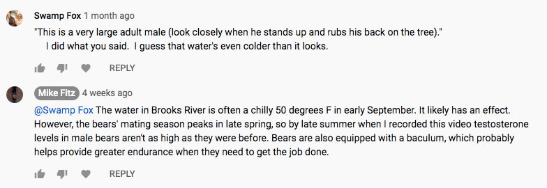
The pursuit of mating opportunities certainly distracts male bears from other life tasks like fishing for salmon. I remember one July when 856 seemed like he didn’t stop courting females for the entire month. While the other males at the river got their fill of fish, 856 fished only occasionally because he was more interesting in reproduction. Near the end of July, he looked well muscled from the exercise of the pursuit but looked as though he had little body fat.
856 often spends a lot of time courting females in early summer and less time fishing compared to many other adult bears. He can afford to do so because his high level of dominance provides access to fishing spots wherever he goes.
“Survival of the fittest” is often thought to refer to athletic fitness or survival instincts, when it is more accurately framed in terms of reproductive fitness. Perhaps the male bears who have the energy reserves and stamina to court female bears for long periods of time with little food are the most reproductively fit. It’s also important to consider that the bears’ mating season ends in early summer, just when food becomes plentiful in Katmai, so a male who doesn’t eat much in June has ample opportunities to make up for it during the next few months.
Questions from the book club’s discussion of Chapter 14: Boundaries (June 12, 2021)
Is there any research showing how reduced attendance during the 2020 pandemic affected the salmon and/or the bears?
As far as I know, there’s nothing publicly available yet. However, biologists at Katmai National Park expanded the bear-monitoring program last year to collect data that might help answer that question. It was an unexpected research opportunity to observe bears at Brooks River at a time of year when typically it is loaded with people.
Certainly the lack of people at the river in 2020, especially when the camp remained closed to the public, allowed bears more space to fish. The greatest influence on the distribution of bears last year, though, was salmon. The record run of sockeye salmon was overwhelming and it provided bears with ample feeding opportunities throughout the river. In a year with fewer fish, I don’t think we wouldn’t have seen bears using the lower river in early summer as much as they did in 2020, no matter how few people visited.
The bears at Brooks are perhaps more human-habituated than other bears. And yet, as 854 Divot’s story proves, they do wander outside the boundaries of the park, where they will encounter humans who don’t operate according to park rules. Can you offer some reassurance — or some insight — about how their human habituation might affect their fate outside park boundaries?
Habituation at Brooks River provides a bear with advantages. It allows access to parts of the river that may otherwise be off limits if the bear isn’t tolerant of people. At Brooks River, people are especially tolerant of bears too through both attitude and regulations designed to protect bears.
Outside the park, they may not encounter the same tolerance. Having a bear prowling outside your cabin at Brooks Camp is one thing. Having it do so near your children and pets is another.
If a habituated bear wanders into King Salmon, for example, its tolerance for humans may lead it to temptation in the form of unsecured food and trash. A habituated bear could more easily become conditioned to seek human foods in that situation. Bears encounter much greater risks around people in those places than they do at Brook Camp.
Some biologists I’ve spoken to speculate that habituation could be context specific. That is, a bear might be able to learn that people in one location are tolerant while people in another location are dangerous. I think this is plausible but I’m not yet convinced it works that way for most bears. Further research is needed.
In many ways winter is a glorious season. There’s nothing quite like the silence of the forest during a winter storm, when the landscape is remade under falling snow. During March, however, when snow has cloaked the land for months and summer seems a distant memory, I begin to dream of greener pastures, so to speak.
I’m not the only one who feels the pull of spring. For many animals, spring is not only a season of renewal but also one of frenzied business. Perhaps nothing symbolizes the end of winter in the northeast U.S. like the return of the amphibians.
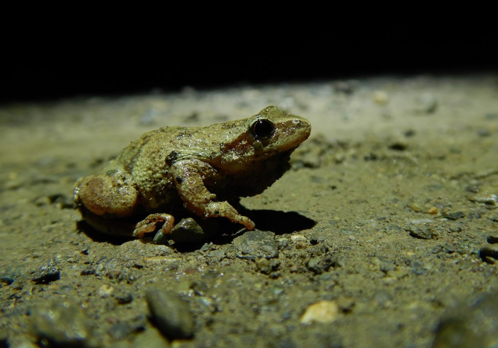
Spotted salamander.
Amphibians in the northeast U.S. lead relatively inconspicuous lives. During summer, I’m lucky to see a handful of spring peepers as I tromp through the forest or poke around my garden. Toads make their rounds, yet are camouflaged well enough to typically escape detection unless they hop. I might spot some bull and green frogs lurking on the edge of a pond, eyeing me warily, but I hear them calling far more often then I see them. Except for the boldly colored red efts or eastern newts, I typically don’t see salamanders unless I search the undersides of down logs, and I won’t see the more fossorial of salamanders, such as the spotted salamander, at all when they inhabit their burrows.
During winter, amphibians are even harder to come by. Tucked within the forest duff, wood frogs and spring peepers survive winter frozen like a popsicle (and I mean, actually frozen, not just cold). Adult newts remain hidden under the ice of their home pond. Spotted salamanders undergo their own form of hibernation in burrows they’ve appropriated from other animals.
Winter is often loath to end in Maine and the thaw usually progresses in spurts. In March or April, the warm days begin to outnumber the subfreezing. Meltwater and perhaps a cool drizzle percolates through crusty snow to the forest floor. Eventually, a storm front pushes through bringing overnight rain instead of snow. If the ground is mostly snow free and the rain coincides with temperatures above 40˚ F, I know it’s time to don my trusty yellow rain slicker and rubber boots for a walk in the dark. The mass amphibian migration nicknamed the Big Night has arrived.
“Feeling cute. Might delete later,” says this spotted salamander.
Early spring this year brought unusually dry and warm weather in my region. The two plus feet of snowpack that lingered into mid March disappeared rapidly, but no rain came until April 10. That evening, right around 8 p.m., a light drizzle began to fall. Although I was unsure if it would be enough to initiate the amphibian migration, I only walked a few hundred yards along my road before I found out.
On the broken pavement, headed north to a small pond, sat a wood frog. Soon after, I found a spring peeper and then a gray tree frog. The amphibians were certainly on the move.
Wood frog.Spring peeper.Gray tree frog.
Activity along the next half mile of road was unsurprisingly sparse as it descended through forest without any close-by vernal pools or ponds. The next hillside, however, brought me through a true hotspot. I could hardly walk 50 feet without finding one or more spotted salamanders on the road.
A spotted salamander glares at me as it crosses the road.Blue-spotted and Jefferson’s salamander form a hybrid complex in Maine. This fine specimen I found is likely a hybrid.
While the frogs I had seen earlier live above ground during the active months, spotted salamanders live the majority of their lives underground or at least hidden under leaf litter, a lifestyle typical of the “mole salamanders” in the genus Ambystoma. They are conspicuous only during their brief breeding period in spring. Spotted salamanders return to reproduce in the same pond or vernal pool where they were spawned only to leave the water and return to their mole-like habits a few days later.
For me, a fellow who is increasingly interested in all critters small, the Big Night is one of the best evenings of the year. For the critters I seek, though, the Big Night can be one of the most dangerous experiences of their lives. Many do not survive their attempt to cross the road.
For wildlife, roads and motor vehicles are one of humanity’s most hazardous inventions. Although estimates vary widely, we probably kill hundreds of millions of vertebrate animals (and maybe even as many as one billion animals) on roads in the U.S. every year. This includes somewhere between 89 and 340 million birds. In 2015-2016, according to State Farm, 1.3 million collisions with large mammals cause enough vehicle damage for drivers to file insurance claims. Pennsylvania drivers led the charge with more than 133,000 wildlife-collision insurance claims. (I grew up and learned to drive in Pennsylvania and have unfortunately experienced more than one collision with deer. I’m not sure I have any family members in PA who haven’t struck deer in a car. Yay for the Keystone State.)
Since small animals like salamanders and frogs don’t cause vehicle damage, their road-caused mortality seems to be poorly quantified compared to large animals. A study from Massachusetts, though, found that motor vehicles are significant source of mortality for individual spotted salamanders and could lead to population extirpation if road mortality reached 20-30 percent of a population. Near prime breeding habitat, a Big Night migration can bring hundreds of amphibians onto roadways per hour. Afterward, when juvenile and adult amphibians disperse from their aquatic breeding habitat, road mortality can also be significant. However, dispersal from breeding ponds is more diffuse in time and space than the initial migration, and we know even less about road mortality during that phase of their lives.
Amphibians aren’t random users of the landscape. They seek out particular habitats. Spotted salamanders, for example, generally breed in the same water bodies where they were born. The collective migration to breeding ponds can funnel many individuals into a small area. This is where data gathering becomes an important conservation tool, especially if we are to lessen their risk of becoming road kill.
On April 10, I walked about three miles between 8 and 11 p.m. (the Big Night isn’t a fitness walk), but more than half of the salamanders I saw crossed the road within a single 100-yard stretch. On April 17, with just the barest spittle of rain falling, I walked the same road and saw no amphibians on it except within the same 100-yard section.
In this Google Earth image the yellow pins mark a concentrated area of spotted salamander sightings on April 10, 2021. A small pond at bottom-center is the salamanders’ destination. The mature forest north of the road offers salamanders good habitat the rest of the year.
I’m fortunate to live along a quiet, rural road where traffic is light even on the busiest days. During my Big Night walks, I may only see three or four cars at most. Still, I find road kill salamanders. So, removing live amphibians from the roadway (in the direction they are headed, of course) gets them out of harms way.
One great thing about the Big Night is that it provides a valid excuse to handle frogs and salamanders. Gently moving them from the traffic lanes can help ensure they don’t become pancakes under car tires.
Road hazards for wildlife is an issue that needs more attention from our policy makers and highway departments. To address it, we need, like so many things, systemic change. Road design must consider the safety of the most vulnerable—such as pedestrians, cyclists, and wildlife—before the convenience of motorists.
Agreed. A community of wildlife experts also believe that the ability for animals to safely cross highways is also a matter of infrastructure too. Providing safe passages for vehicles and people via wildlife crossing structures and fencing makes highways work better for all. https://t.co/0yK8WvFDA0
Individually, we can help by joining community science efforts such as the Big Night to document amphibian migrations and amphibian road mortality. We can also drive less, drive slower, and avoid driving at night when possible. Perhaps you might even be able to convince your town to temporally close roads during springtime amphibian migrations or build structures to guide amphibians under roads safely.
Amphibians bridge the aquatic and terrestrial worlds. They hail from an era in Earth’s history when vertebrates had yet to thoroughly colonize the continents. Their longevity as a taxonomic order (amphibians first appeared more than 350 million years ago) underscores that the strategy works. Yet, amphibians face increasingly dire challenges due to roads, disease, habitat loss, non-native species, the exotic wildlife trade, and climate change. Collectively, amphibians are the most threatened group of animals on the planet. Since we are the collective cause of these threats, then we owe it to amphibians to correct them.
The Big Night represents the transition between winter dormancy and the frenzied attempts of many amphibians to reproduce. Before documenting their migration across my road during the past two years, I had no idea that most spotted salamanders funneled to and crossed it along a single 100-yard long section. Searching for amphibians along roadways has helped me better understand their lives and their vulnerabilities in an increasingly human-dominated world.
Many years ago, inspired by the complicated and fascinating intersection of bears, salmon, and people at a most unique place, I conceived the idea of a book that captured the story of Brooks River in Katmai National Park.
Part one of The Bears of Brooks Falls explores the establishment of Katmai National Monument, from the moments preceding the largest volcanic eruption of the 20th century to the discovery of the surreal Valley of Ten Thousand Smokes. These events inspired the creation of Katmai National Monument and, soon after, the efforts to expand the park for wildlife like brown bears.
Today, Katmai is most famous for its brown bears. Part two is devoted to their lives as well as the salmon that the bears depend on for their survival. I explore the marvel of the hibernating bear, discover Brooks River from a cub’s perspective, and follow the tribulations and growth of young bears recently separated from their mother. I also ponder how Katmai’s brown bears experience reproduction, competition, hunger, and death.
Few organisms are as important to an ecosystem as sockeye salmon are to Brooks River. These fish face tremendous obstacles and challenges. From freshwater to the ocean and back again, they travel thousands of miles, running a gauntlet of predators to fulfill their destiny. The journey ends when they sacrifice their lives to reproduce. Salmon are Katmai’s keystone, driving Brooks River’s productivity and significance.
In part three, I examine modern humanity’s influence over Brooks River. Humans may be the river’s biggest wildcard. Climate change looms large over the land and seascapes, and people alter the behavior of the bears that make the scene so special. The infrastructure needed to support thousands of visitors and their recreational activities invites conflict with bears. Managing bears and people in such a small area is especially challenging, provoking a decades-long and often emotional debate about the river’s future.
Brooks River’s bears live in a land that straddles the border between the wild and human realms. Their lives are intertwined with ours, and as a result Brooks River is a microcosm for many of the issues facing our national parks. No book has captured this story before.
I’d also love to know what you think of the book. Drop a comment in response to this post, email me, or post a review on the websites of major booksellers.
In September 2017, I took a brief trip to Brooks Camp, the world-famous bear-viewing site in Katmai National Park. This was a rare opportunity for me to visit for fun, as opposed to traveling there to work for the National Park Service or explore.org.
Bear watching is the most popular human activity at the river and the close proximity of Brooks River’s brown bears to the designated wildlife-viewing platforms makes for some exceptional photographic opportunities. However, I toted only a small point and shoot camera with a limited zoom. Taking good photographs, therefore, was challenging so I focused more on recording video of bears. Video can also provide a sense of scale that is sometimes difficult to capture in photos, especially when a titan is in the vicinity.
On the last morning of my trip, I found the colossal 747 walking out the river to challenge a competitor at Brooks Falls. This is what happened.
After I uploaded this video to YouTube, I hadn’t expected it to garner much attention, but a little more than three years later Giant Fat Bear at Brooks Falls is approaching one million views and has generated more than 3,500 comments.
When a video goes viral or becomes modestly popular, you can either let it develop a life of its own or attempt to heighten the experience. A captivating video is a chance to give people more than a few seconds of entertainment. It presents an opportunity.
People are naturally curious, especially so toward animals, but context and relatable, meaningful information are often needed to match that curiosity. How might those in the fields of heritage interpretation or science communication provide the casual viewer with a more meaningful experience? Here are a few of the strategies that I found successful with a short video about a fat bear.
Anticipate what a person with no context of the place or subject might need to know. The universe is a big place. Put yourself in the mindset of someone who does not have your experience or background. Although people relate to brown bears easily and on many levels (they definitely love a chonky bear), the natural history and ecology of these animals are not universally or even well known. I soon realized my modest video description was inadequate. Viewers were drawing conclusions and asking questions that I had not anticipated. They wanted to know more.
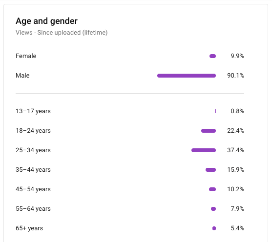
Get to know the demographics of your audience. If you read this blog regularly, you’re familiar with the bearcams in Katmai National Park. While the bearcams are extremely popular, receiving tens of millions of views each year, explore.org’s webcam analytics document that the bearcam audience skews heavily toward the female gender and adults over the age of 45. Analytics on Giant Fat Bear at Brooks Falls, however, are much different. Viewers are typically 18 – 35 years old and overwhelming male.
That audience will likely react to and evaluate information differently than the typical bearcam commenter. And, they are relating to different things in the bear world. Knowing that, I might respond to questions and comments on the video in ways that I wouldn’t during a live chat on the bearcams.
If a video generates a lot of similar questions or leads people to make assumptions, write an FAQ to address those and then put it some place obvious. When the views on Giant Fat Bear at Brooks Falls began to skyrocket, I took mental notes on the questions it generated to see if there was a pattern, while keeping in mind that the internet is a big place where people from all over the world can access the video. In addition to the questions people were asking, the number of comments prompted me to consider how I could provide further context. I identified three questions originally, wrote concise answers for them, and pinned the FAQ to the top of the video comments.
The FAQ didn’t stop people from asking questions (and I didn’t it want it to), but it caused the queries to change. Questions became less repetitive. They branched to other facets of bear biology. Plenty of people appear to be reading the FAQ as well. As of this writing, the FAQ on Giant Fat Bear has 2.8 thousand likes and zero dislikes.
The FAQ proved to be particularly valuable in ways that I did not expect. Much of the internet is little more than websites recycling (to state it mildly) the work of others. When the video first began to trend in 2018, the FAQ was often the only source of info used by websites looking to generate click-bait content based off my video. It was used in the prestigious Daily Mail, for example, to produce one of the tabloid’s most fact-laden articles ever.
When in doubt, assume that a person asks questions in good faith. It’s not always easy to discern the difference between questions asked in good or bad faith, and trolls should not be engaged. However, each person experiences life through the lens of a unique worldview and knowledge base. Furthermore, access to open space and outdoor recreation (both physically and inclusively) is far too limited for many people, especially among those that experience racism and discrimination. Yet biophilia and an instinctual curiosity reverberates through each of us, and by asking a question a person signals that they want to learn.
This is why I included “Are you making fun of the bear’s fatness?” in the FAQ. It’s not dumb to not know much about bears. Most of us don’t have easy access to bear habitat, let alone the opportunity to observe wild bears. People also post a lot of offensive stuff online. Given the unfortunate status quo of social media, I don’t fault anyone for thinking I might’ve been making fun of a fat bear instead of simply describing him. It is not obvious to everyone that bears must get fat in order to survive.
Think carefully about offers to license your content. Video distribution agencies prowl social media sites looking for engaging videos to add to their collections. Their offers to license and distribute your video look appealing at first glance, but I eventually rejected them all. Providing meaningful information and context was more valuable to me than the ten cents I might make through a third party distributor. I was particularly hesitant because some viral media companies distribute wildlife videos and spread them without context or even checking to see that video was recorded ethically. By rejecting these solicitations, I sacrificed reach but remained in control of the flow of information.
Lastly, choose a catchy title for your video but also one that isn’t confusing. Some comments on Giant Fat Bear at Brooks Falls suggest that a handful of people read the title literally and expected to see a giant fat bear fall.
I’ve greatly enjoyed seeing how this simple video has inspired interest in bears, art, memes, and eventually helped to propel 747 to Fat Bear Week greatness.
As I draft this post, Giant Fat Bear continues to generate questions and comments. Many of the comments are simple jokes, but I still count those as a win. It means that a person was engaged. For those few seconds (and more if they asked a question) they were thinking about bears.
I have no allusion that leaving a comment on a video is the same as stewardship and advocacy for wild animals. But the first step towards stewardship is awareness and understanding. As Freeman Tilden, the founder of modern heritage interpretation, wrote in Interpreting Our Heritage, “Through interpretation, understanding; through understanding, appreciation; through appreciation, protection.” We get there one step at a time and we get there more easily with guides along the way.


![Screen shot of youtube comment. Text says, "Gladhe 1 month ago He protecc He attacc He most importantly Eat big mac!]](https://fitznaturalist.com/wp-content/uploads/2021/01/screen-shot-2021-01-22-at-9.03.55-pm-1-e1611675551409.png)
