As is tradition—going way back to the before times (2017)—I’ve endorsed a bear for Fat Bear Week. This year’s bracket might be difficult to predict, but with voting commencing today at 12 p.m. Eastern and continuing through October 11, it’s time to throw my weight behind a Fat Bear Week contender.
I’d let him speak for himself but his mouth is usually too full of salmon.
Friends, humans, and ursids, let us stand in awe of a true competitor. A candidate with conviction. A candidate with strength. A candidate that stands up for what he believes. A candidate the size of a double-wide refrigerator. This Fat Bear Week vote for the mighty 747.
747 returns to Brooks River every summer as a giant and just keeps getting bigger.
Perhaps you don’t want to listen to me. After all, I’ve endorsed 747 before and it hasn’t usually led to his victory. Our culture is celebrity obsessed, though, so maybe you’ll listen the expert opinions of these randos.
Homer remarked that 747 is the only other individual whose blubber flies like his.
Dr. Evil threatened world destruction if 747 fails to win.
I spoke with the President too, believe it or not. (He seems to clear his schedule when you have something to say about Fat Bear Week.) Joe Biden noted that 747 grew proportionally faster than this year’s inflation rate.
747’s summer was one of competition and success. In June and July, he yielded space to bear 856. By August, however, 747 turned the tables. He frequently challenged and displaced his long-time rival.
It’s hard work staying dominant and getting fat too. Bears as large as 747 tend to overheat easily, and while their limb bones are built to support their great mass sometimes climbing those hills is a struggle.
Name another bear who struggles uphill with such finesse. Here's a full minute of 747 riding a leisurely struggle bus. pic.twitter.com/mUoM4JxbbK
You also can’t get that fat without eating a lot of food, and 747 excels in this life goal. Although we don’t know exactly how many fish 747 ate this year, a study about brown bears on Kodiak Island may provide some insight.
Brown bears shed their fur once per year in early to mid summer. Since new fur grows during a bear’s active season, it contains a record of what the bear ate during that time. Studies of captive bears had previously determined the relationship between the mercury content in food and the mercury content in hair. To apply this to bears on Kodiak, researchers first determined how much mercury is found in the Pacific salmon that spawn on Kodiak. They then analyzed the mercury content found in the bears’ hair to gain an estimate of salmon consumption. Large adult males, on average, ate 6,146 pounds (2,788 kg) per bear per year! Some adult males ate a lot more, though, as much as 10,000 pounds of salmon. Since 747 fished at Brooks Falls almost every day between late June and mid September this summer, then his total salmon consumption may likely have been near the upper end of that spectrum.
For fisheries managers and biologists, these statistics are more than pieces of trivia. They are necessary to help inform decisions about salmon escapement goals, so that salmon runs are sustainable for people and the wildlife who depend on them. The aforementioned Kodiak study found that “the estimated population of 2,300 subadult and adult bears [on Kodiak] consumed 3.77 million kg of salmon annually, a mass equal to ~6 percent of the combined escapement and commercial [salmon] harvest (57.6 million kg).” Katmai National Park’s bear population is about as large as Kodiak’s, and when we work to sustain salmon runs we’re also celebrating the life they provide to many other species and individuals, such as bear 747.
Bears get fat to survive winter hibernation, and Katmai National Park’s Fat Bear Week bears are well positioned to weather the oncoming famine. But there’s candidate who eclipses the rest. Your bear might be a 10 but 747 is 1,400 pounds. I’m voting for 747, are you?
Download your bracket from FatBearWeek.org and go there to vote in each Fat Bear Week match from October 5 to 11.
THE THING ABOUT BEARS IS THAT A LOT OF THEM ARE BIG. BUT LIKE HAVE YOU SEEN 747?? HE’S SO BIG. A GIANT, REALLY. HE JUST SITS THERE AND FISHES LIKE THERE’S NO TOMORROW. I MEAN HE HARDLY LEFT THE FALLS ALL SUMMER. DOESN’T MATTER HOW COLD THE WATER IS OR WHICH OTHER BEARS ARE THERE….
Brooks Falls is, without question, the most famous place in Katmai National Park and one of the most famous wildlife-watching destinations in North America. Even if you can’t place it on a map, you’ve likely seen it in a wildlife film, in a photograph, or on TV. Search “bear catching salmon,” for example, and nearly all of the first 50 photos are of a bear standing on the lip of Brooks Falls.
On a sunny, warm morning in mid July 2021, I arrive at the boardwalk leading to the falls after hiking the short trail through the surrounding spruce forest. It’s a promising time to visit. The early summer sockeye salmon migration is in full swing and hungry bears are eager to catch them. But about halfway along the boardwalk, I realize the chances of reaching the falls in a timely manner are slim. At a covered platform nicknamed the Treehouse, where the boardwalk forks and leads to different viewpoints of the river, there’s a wall of people.
Under the Treehouse roof, about 25 people surround a frazzled park ranger who clutches a metal clipboard. The clipboard and the scribble of names he places on it are the ranger’s only lifeline to a semblance of order—it’s the waitlist for the groups wanting to gain access to the platform overlooking the falls. Like a restaurant maître d’, the ranger greets new arrivals, take their names, and asks others to wait their turn when people fill the Falls platform to its 40-person capacity. He also imposes a one-hour time limit for people at the Falls so that those who are waiting have a chance to go there.
Few people normally hang out at the Treehouse voluntarily, since if offers no lines of sight to the river and its bears. Therefore, the crowd at the Treehouse this morning indicates that the wait time to access the falls is substantial. Having staffed the platforms as a ranger in the past, I don’t wish to add to this ranger’s workload or anyone’s wait time this morning. Instead, I look for space at the adjacent Riffles Platform where rangers don’t manage a specific capacity.
I don’t find much space there either. About 20 people occupy it already. Even more fill in gaps within a few minutes of my arrival as the queue for the Falls platform grows larger. With 40 people at the falls, 25 in the treehouse, 30 or more at the nearby Riffles platform, and surely more to come, I leave for a a less crowded space.
The lower fourth of Brooks River meanders through seasonally flooded marshes and gravel bars before spilling into the glacially-fed and turquoise-colored Naknek Lake, the largest lake wholly contained within any U.S. national park. The lower river offers space and safety for mother bears and their cubs who choose to avoid the risks posed by the larger males fishing at the falls. Young, recently weaned bears also use the area as a place to socialize and graze on tender grass with less risk of encountering a larger, more dominant competitor. It’s also the most ecologically diverse place along the river so even if there are no bears in sight, there’s usually something to catch your eye.
About 20 minutes after leaving the falls boardwalk I arrive at the lower river and station myself on a platform adjacent to the long footbridge that leads to Brooks Lodge and the park visitor center. The perch allows me to see most of the river mouth as well as the meandering reverse S-curve upstream. Few bears use the lower river as I sit, although the vicinity remains filled with activity. A near continuous high-decibel, high-pitched whine fills the air as float planes arrive and taxi to the lakeshore. They disgorge their passengers out of my line of sight, but each plane must’ve been filled to capacity. Over the next hour, I count more than 200 people crossing the bridge toward the falls. Almost none walk in the opposite direction. I sympathize mentally with the Treehouse ranger who is likely clutching his clipboard even more tightly.
Later in the day, another ranger reports to me that the wait to reach the Falls platform exceeded two hours at its peak. In total more than 350 people arrived at Brooks Camp this day, which doesn’t seem like much, but that’s on top of the pilots and guides who brought people here, the 30 people who stayed in the campground, the 50-60 people who stayed in the lodge, the 30 concession employees, and the 20 park staff. Even with my conservative math, about 500 people occupied Brooks Camp, all attempting to share a 1.5 mile-long river corridor with two to three dozen brown bears.
By the end of summer 2021 more than 15,000 people visited Brooks Camp—most of whom arrived in July and all of whom used infrastructure largely designed in the 1980s and 1990s to accommodate about half to two-thirds as much at most. It’s double the visitation of 2007, the first year I worked as a ranger at Brooks Camp.
The popularity of national parks is a welcome sign that these spaces are important and meaningful to broad swaths of the public. It wasn’t that long ago, that a National Park Service director wondered aloud whether parks were losing their relevancy. However, at the same time that our national parks experience record high visitation many more people encounter significant barriers that inhibit them from experiencing these places. I might’ve been sharing Brooks River with 500 people that day last July, but millions more are denied the opportunity. In an era of great crowding in our national parks, I wonder, do we have the determination to make parks accessible to everyone?
⚠️Wednesday, Mar. 23 9:20am: The park is currently full, and we are temporarily delaying entries into the park. Vehicles attempting to enter the park should return in 3-5 hours.
Consider visiting nearby attractions. Check this account for updates before returning.
The first national parks in the United States were protected for their scenic splendor, unique features, and wildlife. Nothing compares to Yellowstone’s geyser basins, Yosemite’s towering granitic cliffs, or Sequoia’s majestic trees. However, broad public support for these areas in the late 1800s was lacking. Yellowstone, Sequoia, Yosemite and Mount Rainier—the first four national parks created by Congress—were remote and difficult to access. Upon their establishment, they lacked the facilities and basic infrastructure necessary to accommodate large numbers of people. Even so, the park boosters, advocates, and visitors who had experienced these landscapes understood they were special places.
To build a constituency for parks and facilitate a national park experience for more people, the earliest park managers built roads, trails, campgrounds, and visitor centers. They hired rangers. They allowed concessioners to build and operate hotels, lodges, restaurants, and trinket shops. After Congress established the National Park Service (NPS) in 1916, the fledging agency doubled down on infrastructure development. During the Great Depression, the Civilian Conservation Corps and Works Progress Administration constructed hundreds, perhaps thousands, of miles of trails and roads within park boundaries. Soon after, a post-WWII travel boom highlighted a need to modernize parks and accommodate a tsunami of people (visitation to all national parks combined increased from about 3.5 million to almost 30 million between 1931 and 1948). The effort was sanctioned by Congress in 1956 through the Mission 66 program, a 10-year-long and billion-dollar plan to expand and modernize facilities and infrastructure in national parks.
Making parks physically accessible to greater numbers of travelers established the experiential paradigm that national parks function within today. Namely, a physical visit to a park inspires people and leads them to become park stewards and supporters.
The effort, it can be convincingly argued, worked. More people visited. More people had great experiences. More people cared for parks. It helped fuel a burgeoning environmental awareness and protection movement. The paradigm, it seemed, had created more stewards than ever before. But not everyone was pleased with the trajectory of tourism in national parks.
In Desert Solitaire, one of Ed Abbey’s most well known essays is “Polemic: Industrial Tourism and National Parks.” Much of the book and “Polemic,” especially, is based on Abbey’s experience working as a ranger at then Arches National Monument in the 1950s, a time before pavement bisected the little visited park in southeast Utah.
Abbey seemed to enjoy his job. He muses something that probably every ranger, including me, has thought at one time or another: “On the rare occasions when I peer into the future more than a few days I can foresee myself returning here for season after season, year after year, indefinitely. What better sinecure could a man with small needs, infinite desires, and philosophic pretensions ask for?”
But, as Abbey saw it, not all was rosy at Arches. He writes, “For there is a cloud on my horizon. A small dark cloud no bigger than my hand. Its name is Progress.” Under the direction of the National Park Service, Arches soon transitioned from an off-the-beaten-path retreat to a major tourist destination.
Abbey experienced Arches as the NPS implemented its Mission 66 plan. He worried and warned that national parks were threatened by “industrial tourism” whose “chief victims of the system are the motorized tourists. They are being robbed and robbing themselves. So long as they are unwilling to crawl out of their cars they will not discover the treasures of the national parks.”
Abbey’s “Polemic,” true to the title word’s meaning, is a scathing criticism of development in national parks and the NPS’s efforts to expand it. “Where once a few adventurous people came on weekends to camp for a night or two and enjoy a taste of the primitive and remote, you will now find serpentine streams of baroque automobiles pouring in and out, all through the spring and summer, in numbers that would have seemed fantastic when I worked there: from 3,000 to 30,000 to 300,000 per year.” *
*Abbey might have exaggerated the numbers here, although visitation did increase substantially between the time Abbey last worked at Arches in 1957 when, according to National Park Service statistics, annual visitation was 25,400 to 135,000 visitors in 1968 when Desert Solitaire was published. In 2021, visitation exceeded 1.7 million.*
Abbey outlined several ways to alleviate crowding and further development such as an end to road building in parks, putting more rangers into the field, and banning cars from parks. “No more cars in national parks. Let the people walk,” he writes. “The automotive combine has almost succeeded in strangling our cities; we need not let it also destroy our national parks.”
If Abbey was angry then, he might feel a rage today. More than 297 million people visited national parks in 2021during a pandemic. More than 327 million people visited national park areas in 2019. Record high visitation stresses the already expansive and often underfunded infrastructure of parks. Parking lots are consistently full; excess cars line the road or their drivers shove their vehicles onto narrow shoulders. Some areas, such as Acadia’s Cadillac Mountain that you need a permit to get in the park parking lot. Herds of us overwhelm trails and overlooks too. Climbing Yosemite’s Half Dome requires a permit awarded through lottery as does Zion’s Angels Landing. You now need a “timed entry permit” to enter Rocky Mountain National Park and drive Glacier National Park’s iconic Going-to-the-Sun Road. Remote hiking areas, where Abbey’s preferred visitors go, are often filled too. When I worked as a backcountry ranger at North Cascades in summer 2017, most every backcountry campsite filled during summer weekends. The overflow spilled into the surrounding national forests, public lands with significantly fewer rangers than national parks.
Clearly, the industry of tourism has grown substantially during the last several decades. Although the implications of this reality is not something I wish to tackle in this essay, our national parks are at a tipping point beyond which I worry the experience of visiting them as well as its wildlife, plants, and scenery will suffer. While I support rethinking how we use cars in national parks and we certainly should not be building new roads, denigrating those who experience parks by car is not the answer. I now see Abbey’s objections to visiting parks by car as ableist.
As an aside, I should note how far my thinking has evolved on this issue. Starting my career twenty years ago, I agreed with Abbey’s no-cars-in-parks stance. Cars are a menace, I thought. (And to be honest, that remains true in many ways. Automobiles kill tens of thousands of people and hundreds of millions of vertebrate animals in the U.S. each year. Transportation also accounts for about 30% of the United States’ greenhouse gas emissions. Driving less would do our world a lot of good.)
Fresh out of college and equipped with good health, I privately sneered at those who drove through parks without riding a bicycle or spending time on the trail. Like Abbey, I wondered, are you really having valid national park experience if you don’t risk hypothermia or sunburn? Yet, most of the time I drove into parks, parked my car and then rode my bike or hiked. I was, hypocritically, dependent on the car and, more importantly, I didn’t consider that the experience of those visiting parks primarily by car as equally valid an experience as my own. Of equal or perhaps even more concern was my rejection of the needs of people who couldn’t visit. “Oh, you can’t come,” I thought, “That sucks but what am I supposed to do about it?” Nature deficit disorder is real, but let’s not pretend that experiencing a national park by car is a cause. There are other much more systemic issues at heart.
When we’ve traditionally explored how to address crowding in national parks, most of the ideas, especially those that have emerged out of the NPS bureaucracy, center around encouraging people to visit less crowded parks, to use shuttles where available like at Zion and Acadia, to visit during less crowded times and seasons, and to encourage people to do more planning or plan like like ranger. Comparatively little thought has been given toward efforts designed to connect parks with people who experience barriers that hinder them from visiting.
With these barriers in place, focusing primarily on congestion in parks is like rearranging chairs in a crowded room, while ignoring everyone that can’t even get in the building.
No panacea exists to solve accessibility issues in our parks. And, thankfully, a growing number of organizations are working toward solutions such as Brown People Camping, Disabled Hikers, Latino Outdoors, National Ability Center, Outdoor Afro, Unlikely Hikers, and Wilderness Inquiry to name a few. There’s one way, however, that the NPS can break the prevailing paradigm almost immediately to provide people from all backgrounds with meaningful national park experiences, and with little more than an internet connection, which brings me back to Katmai.
While at Brooks River, I don’t share the river with only the few hundred people on the ground with me. I share every moment with many thousands of people watching from around the world. In 2012, Katmai National Park partnered with explore.org to host streaming webcams at Brooks River. Several webcams (collectively and affectionately known as the bearcams) stream live footage of Brooks River each summer and fall, allowing anyone with an internet connection the opportunity to watch bears fishing for salmon.
Each year, the bearcams receive millions of views. During 2021, for example, the bearcams saw 16.5 million page views on explore.org. People also watched from 110 countries and all 50 states. The programs that rangers and I host on the bearcams reached hundreds of thousands of people collectively. These numbers are several orders of magnitude larger than even the record setting visitation experienced at Brooks River during the same year.
Although the bearcam experience lacks the immersiveness of an on-site visit, its depth far surpasses anything you’d typically get in person. A webcam experience isn’t limited by flight schedules, vacation days, outdoor skills, fitness, or wellness. It lasts as long as you want. It is accessible whenever you want. Through the bearcams, we watch bears not for a hurried few hours. We watch across weeks, seasons, and years. We see bears return to the river every year of their lives. We watch mother bears rear multiple litters of cubs, and those cubs, in turn, mature through sub-adulthood and adulthood. We discern the breadth of each bear’s individuality as it decides how to make a living. We witness the ebb and flow of the largest salmon runs left on the planet, how the fish underpin Katmai’s ecosystem, and how their year-to-year variability influences the behavior of bears and other wildlife. There’s no wildlife-watching experience quite like it.
If you haven’t experienced a national park through a webcam, then it might be difficult to envision that watching a park through a webcam can be meaningful. But, friends, it is true. A study comparing and contrasting on-site (i.e. in-person) and online (webcam) visitors to Brooks River found that webcam viewers emotionally connected with bears at higher levels than on-site visitors. The same study found that webcam viewers also support protections for bears at higher levels than people who visit in-person. In fact, support for bears and national parks among webcam viewers equalled or exceeded those reported by on-site visitors on almost all metrics evaluated in the study. Subsequent research has found that the bearcams provide mental health benefits and that people greatly value the individual animals that they see through webcams. To expand these lines of research, I’m collaborating with Dr. Lynne Lewis from Bates College, Dr. Leslie Richardson from the NPS and Dr. Jeffrey Skibins from East Carolina University to conduct and analyze more on-site and online surveys of Katmai’s visitors. Our analyses of online surveys from 2019 and 2020, for example, have confirmed previous results and have even underscored the importance of individual, easily recognized bears in people’s experience.
As the aforementioned crowding issues demonstrate, providing space for everyone who wants to visit parks in-person isn’t feasible or sustainable for Katmai or any other national park. It is feasible, however, to provide meaningful, memorable wildlife and nature-based experiences through the democratizing and stewardship-raising force of webcams. (And if you don’t believe me after all this, please go to the bearcams and ask for yourself in the comments.) It’s long past time for more national parks to utilize webcams to bridge barriers that hinder people from finding meaning and value in national parks and other wild spaces.
I’ll be the first to admit that the bearcam experience is different than visiting Katmai in-person, and my advocacy for the use of webcams does not mean I believe webcams can or should replace the in-person park experience. Nothing that a computer screen provides can truly replicate the wellspring of awe that I feel while standing at Brooks Falls and seeing a dozen bears compete for fishing spots. But, for almost everyone except very fortunate individuals like me, the in-person bear watching experience is ephemeral. Only a tiny fraction of Brooks Camp’s visitors return more than once, according to the two most recent in-depth visitor surveys (2006 and 2014). It’s a once-in-a-lifetime trip for many. For others, it’s not feasible at all.
We can’t build our way out of crowding and access issues like we did after the post-WWII tourism boom or try to shove people into parks during increasingly crowded “non-peak hours” or “shoulder” seasons, not if we want to ensure a high-quality experience, the integrity of park ecosystems, or address the systemic barriers that prevent many people from visiting parks. In contrast, webcams in national parks can provide a form of nature-based equity. They create life-long and devoted stewards among those who may never visit in-person. They help our nature-starved societies find connections with the non-human realm. They heal people.
National parks rank among the nation’s most revered landscapes, and their place within American culture is no accident. In the 150 years since Yellowstone National Park’s establishment, the national park idea has evolved. Yellowstone and other parks are much more than places “set apart as a public park or pleasuring-ground for the benefit and enjoyment of the people.” We value parks for the solace they give us, the fun we experience in them, the wonder and awe they inspire, the opportunity to consider our shared history, and, of course, for the plants, animals, and natural processes that parks harbor. I cherish my time in parks. Everyone deserves access to similar opportunities.
In the United States at least, many of us are eager to return to some semblance of normalcy in a COVID-positive world. Our governments and public discourse are a hot mess of arguments about how to best achieve this. In the context of national parks, other public lands, and wild areas, however, “normal” does not equate universal access. It never has. This upcoming spring and summer, national parks will once again be overwhelmed with people. Rangers will do their best to cope, but without more rangers and the regulatory and policy tools to address congestion, the NPS will go back to its default mode: put out active fires, ignore the tinder, and hope the flames don’t spread.
Katmai National Park existed within the standard visitation paradigm for decades. For those who visit to watch bears in-person, it is an amazing and profound experience. When I worked there as an interpretive ranger, when I’ve visited during my free time, and when I’ve returned as a fellow with explore.org, those moments when I watched bears expressing their survival instincts are experiences more meaningful and memorable than almost any thing else I’ve done in my life thus far.
I last worked as a ranger in Katmai in 2016 though. Without webcams Brooks River would be a fading memory by now, no matter how many photos I took or journal pages I wrote. With the bearcams I, along with anyone else with an internet connection, can return at any time to find inspiration in the beauty of our world as well as the tenacity and intelligence of wild animals. Watching bears, whether in-person on online, creates life-long memories and inspires stewardship. Are national parks truly spaces for everyone? Not yet, but if more parks use webcams as a tool to reach people there’s no reason they can’t be.
Life as a champ is rough. Rivals look to take advantage of any weakness you might show. Arm chair critics analyze your every move. Fans expect perfection. When the next championship tournament rolls into town your body has aged another year and your preferred food has worked its hardest to evade and escape you. Meanwhile, you’re trying to live your best life, because you are a bear and the concerns of humans matter not to you.
Yet, for those of us who recognize greatness and celebrate success when we see it, there is one clear choice for Fat Bear Week 2021—the mighty 747.
Long-time readers of this blog may be thinking, “This again?”
…Let me tell you dear friends: 747 is as fat as ever. He deserves your Fat Bear Week vote.
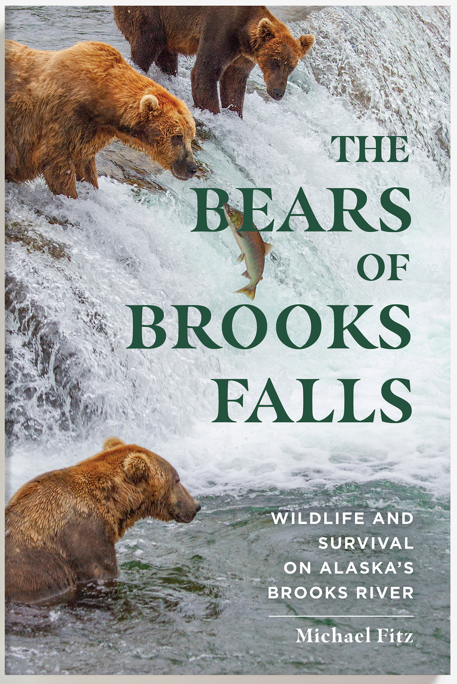
Brown bears get fat to survive. Their obesity (and it is that since a bear’s body fat percentage is routinely 20-30 percent or more when they begin hibernation) is a savings account. In the den, bears do not eat or drink. They stay warm and hydrated by burning body fat. Unlike utilizing muscle for energy—a process that produces metabolic wastes that must be recycled, sequestered, or purged from the body—burning fat is a relatively clean fuel as I write in chapter 4 of my book, The Bears of Brooks Falls.
It’s akin to cultivating mass only to carefully harvest it later. Just not for vanity’s sake, bro.
747 cultivates mass at an exceptional rate. This summer, he reigned as Brooks River’s most dominant adult male. Even the river’s long-time dominant bear, 856, would not challenge him, and as a result 747 had nearly free access to any fishing spot of his desire.
A single brown bear can eat thousands of pounds of salmon per year. The largest can eat 6,000 to 10,000 pounds. Given his size, appetite, high rank in the bear hierarchy, and his keen fishing skills, 747 is more than capable of eating many thousands of pounds of salmon each summer. At Brooks Falls, he intercepts a great deal of fish by being at the right place at the right time and waiting for his food to come to him. When Brooks River’s sockeye migrated upstream, 747 was primed to harvest them.
He’s so successful that in September 2019 and again in September 2020, he was estimated to weigh more than 1,400 pounds. This places him, as I estimate, among the top one percent of brown bears based on body mass.
Even with his size, he remains agile.
747 reminds Grazer and cubs that he's still a dominant big boy at Brooks Falls. pic.twitter.com/mNNNF3OD66
And yes, that is a tapeworm hanging on for a ride.
Fat Bear Week celebrates the success of Brooks River’s bears, the ecosystem and salmon that sustain them, and the bears’ abilities to get fat and survive. 747 exemplifies success among adult male brown bears. He deserves your vote and a repeat Fat Bear Week victory.
August 6, 2015. I stand at the crest of Katmai Pass, remarkably alone in an exceptionally quiet place, not having seen or spoken to a person in five days. Surrounded by wildness, I couldn’t help but think of the transformational moments that occurred here about 100 years before.
While wildlife such as brown bears take center stage in Katmai National Park today, volcanoes originally placed Katmai on the world map. Each national park is unique, but Katmai stands apart from all others for a landscape that did not exist before June 6, 1912.
An extinct fumarole in the Valley of Ten Thousand Smokes.
On June 6, 1912, around 1 p.m. in the afternoon, Novarupta volcano exploded at the head of the isolated Ukak River valley. The eruption continued for 60 hours, plunging the region into darkness. It was the largest eruption of the 20th century and the fifth largest in recorded human history. Novarupta unleashed roughly 4 cubic miles of ash and 2.6 cubic miles of pyroclastic flows. In total, this represents 3 cubic miles of underground magma, an output greater than the eruption of Krakatoa in 1883 and 30 times more than the eruption of Mount Saint Helens in 1980. The eruption drained a magma chamber underneath the 7,600-foot Mount Katmai, creating a 2,000 foot deep caldera, and flooded the area near Novarupta in hundreds of feet ash and pumice.
In the aftermath, the Katmai area, particularly the mainland Pacific coastline and interior regions near Mount Katmai became uninhabited. What seemed to be a wasteland, however, would soon inspire the movement to establish Katmai National Park.
Robert Griggs was a professor of botany at Ohio State University when, in 1915, he led a National Geographic Society expedition to explore vegetative recovery on Kodiak Island. About of foot of ash fell on Kodiak in 1912 and Griggs found the town “bleak and desolate” with only tall shrubs, trees, and hardy perennials surviving above the ash when he visited in 1913.
Upon his return to Kodiak in 1915, however, Griggs found a wholly different place. The island was verdant. As he recalled, “[I] could not . . . believe my eyes. It was not the same Kodiak I had left two years before. . . . I had come to study the revegetation, but I found my problem vanished in an accomplished fact.” Griggs concluded the foot-deep ash, rather than killing the hardy perennials underneath, served as a mulch that retained soil moisture and suppressed competition for space and nutrients.
Instead of remaining on Kodiak watching the grass grow, Griggs decided to explore the area closer to the eruption center with his remaining time. Landing in Katmai Bay with two expedition companions, Griggs discovered a strikingly different scene than the greenery of Kodiak, one that he described as an “entrance to another world.” It seemed the entire world was covered in ash. Traveling conditions were so difficult—they routinely encountered thigh-deep quicksand and dangerous river crossings—that the team could not ascend far up the valley. The little he saw, though, convinced Griggs that the area was worthy of further exploration.
The next year, 1916, Griggs returned determined to reach Mount Katmai, then thought to be the sole source of the 1912 eruption. His larger and better-equipped expedition slogged up valley that July and eventually climbed Mount Katmai, becoming the first people to gaze into its 2,000-foot deep caldera.
While on the caldera rim, Griggs thought he saw wisps steam wafting from the far side of the volcano. He would soon discover what lay on the other side but was wholly unprepared for what he saw. I’ll let this excerpt from my book, The Bears of Brooks Falls, describe what happened next.
July 31, 1916 was a tiresome day for Griggs and his two partners, Donovan Church and Lucius Folsom. Their legs remained fatigued from their second Mount Katmai climb and the ash beds offered little firm ground to stand on.
Not far from the highest point in Katmai Pass, Church gave out, “incapacitated by too many flapjacks at breakfast” and waited while Griggs and Folsom continued onward. Griggs’ first glimpse through the pass didn’t hint of much worth investigating except more ash and pumice, but just as he considered turning back a tiny puff of steam caught his attention. This fumarole, or volcanic gas vent, wasn’t particularly large, but the day was damp and chilly so Griggs used it practically, warming his hands in the condensing steam. Shortly afterward he spotted another plume rising from a larger fumarole in the distance. Curiosity hastened Griggs forward and he climbed a small hillock for a better vantage.
“The sight that flashed into view . . . was one of the most amazing visions ever beheld by mortal eye. The whole valley as far as the eye could reach was full of hundreds, no thousands—literally tens of thousands—of smokes curling up from its fissured floor.
“After a careful estimate, we judged there must be a thousand whose columns exceeded 500 feet. I tried to ‘keep my head’ and observe carefully, yet I exposed two films from my one precious roll in trying for pictures that I should’ve known were impossible. For a few moments we stood gaping at the awe inspiring vision before us…It was as though all the steam engines in the world, assembled together, had popped their safety valves at once and were letting off steam in concert.”
With the day waning and Church still waiting on the other side of Katmai Pass, Griggs and Folsom had little time to explore further, but this was truly virgin territory. No one had set foot in this valley since the eruption irreparably altered it. No one had felt the hot earth under their shoe leather or warmed their hands next to the fumaroles. No one had seen the eruption’s epicenter, the steaming dark gray lava dome Griggs would later name Novarupta. After roughly estimating the number and extent of visible fumaroles, he christened the landscape the Valley of Ten Thousand Smokes.
Griggs didn’t return to his base camp until very late in the day. Despite his fatigue he found sleep impossible, his mind whirling with thoughts about the valley he had just found. The landscape was “unseen and unsuspected…until this hour…I had yet only a very inadequate conception of the place we had discovered, but I had seen enough to know that we had accidentally discovered one of the great wonders of the world. I recognized at once that the Katmai district must be made a great national park, accessible to all the people, like Yellowstone.”
Griggs returned home later that summer and began immediately to lobby for a national park in the Katmai region. With the support of the National Geographic Society and their contacts in the federal government, President Woodrow Wilson proclaimed Katmai National Monument in 1918.
Standing in Katmai Pass about 100 years later, I thought of the moments that Griggs and Folsom experienced as they wandered into the Valley of Ten Thousand Smokes for the first time. With the heat trapped in the ash and pumice having almost completely dissipated, there are no fumaroles in the pass today. Large lava flows from the southwest flank of Mount Trident, even fresher than the 1912 deposits, constrict the valley leading to the pass from the south. A wrinkled cryptogamic soil covers much of the pumice, anchoring the airy gravel in place. The veneer of glaciers on the nearby volcanoes has thinned as the climate continues to warm.
Still, the scene remains remarkably similar to that in which Griggs experienced. No roads or maintained trails snake their way into the Valley or the pass. The views are unimpaired. No light pollution reaches its night skies. In calm weather, your footsteps and heartbeat are often the only sounds—a quiet so immense that the rip of a jacket’s zipper feels like an intrusion. The Valley of Ten Thousand Smokes is contradictory, both wholly different and very much the same as it was when it inspired Griggs to pursue permanent protection for a unique landscape on the face of the Earth.
In 1912, the Alaska Peninsula was forever changed. Rarely has a single event—one that humans witnessed—catalyzed the creation of a national park. If you’ve been fortunate enough to experience the sublimity of wild landscape then perhaps you’ve also experienced something akin to what Griggs felt at Katmai Pass in 1916. The legacy of the discovery of the Valley of Ten Thousand Smokes continues to shape the history of Katmai.
Looking north in Katmai Pass near the spot where Griggs and Folsom found their first fumarole. The Valley of Ten Thousand Smokes is found just beyond Mount Cerberus at center.
It’s been two months since my book, The Bears of Brooks Falls, was released for your reading pleasure. Whether you’re fortunate enough to visit Brooks River in person or if you are a fan of the Brooks River bearcams on explore.org, I hope the book will become a valuable companion to your bear-watching experience. I’ve been pleased to find many people have enjoyed it and found its storylines to be enlightening.
I also hope it’s provoked your curiosity about bears, salmon, Katmai National Park, the history of national parks, and the evolving role that people play in parks and other wild landscapes. With bearcam season right around the corner (expect the cams to go live in mid to late June), I’m also coordinating with bookstores to host online talks about the book.
There’s been no designated place for readers to ask questions about the book though, so let this post serve that purpose. If you have a question or a comment about something you read in The Bears of Brooks Falls, then please drop it in the comments. I’ll do my best to reply. And, of course, I’ll be online almost everyday during bearcam season to answer your questions about bears and salmon as the resident naturalist with explore.org.
Many years ago, inspired by the complicated and fascinating intersection of bears, salmon, and people at a most unique place, I conceived the idea of a book that captured the story of Brooks River in Katmai National Park.
Part one of The Bears of Brooks Falls explores the establishment of Katmai National Monument, from the moments preceding the largest volcanic eruption of the 20th century to the discovery of the surreal Valley of Ten Thousand Smokes. These events inspired the creation of Katmai National Monument and, soon after, the efforts to expand the park for wildlife like brown bears.
Today, Katmai is most famous for its brown bears. Part two is devoted to their lives as well as the salmon that the bears depend on for their survival. I explore the marvel of the hibernating bear, discover Brooks River from a cub’s perspective, and follow the tribulations and growth of young bears recently separated from their mother. I also ponder how Katmai’s brown bears experience reproduction, competition, hunger, and death.
Few organisms are as important to an ecosystem as sockeye salmon are to Brooks River. These fish face tremendous obstacles and challenges. From freshwater to the ocean and back again, they travel thousands of miles, running a gauntlet of predators to fulfill their destiny. The journey ends when they sacrifice their lives to reproduce. Salmon are Katmai’s keystone, driving Brooks River’s productivity and significance.
In part three, I examine modern humanity’s influence over Brooks River. Humans may be the river’s biggest wildcard. Climate change looms large over the land and seascapes, and people alter the behavior of the bears that make the scene so special. The infrastructure needed to support thousands of visitors and their recreational activities invites conflict with bears. Managing bears and people in such a small area is especially challenging, provoking a decades-long and often emotional debate about the river’s future.
Brooks River’s bears live in a land that straddles the border between the wild and human realms. Their lives are intertwined with ours, and as a result Brooks River is a microcosm for many of the issues facing our national parks. No book has captured this story before.
I’d also love to know what you think of the book. Drop a comment in response to this post, email me, or post a review on the websites of major booksellers.
Origin stories seem to be almost requisite for superhero movies, even for well-known characters. (Like, we all know by now that a radioactive spider bit Peter Parker and Bruce Wayne witnessed the murder of his parents; so perhaps the next time Hollywood decides to reboot their tales, maybe just skip over those parts?) Landscapes, on the other hand? Their origins are not investigated nearly enough.
In my last post, I introduced the glacial origins of Brooks River, perhaps the most iconic wildlife viewing site in U.S. national parks. This was far from the full story though. After glaciers sculpted the land, a series of dramatic changes occurred as the river evolved into its current form. In this online chapter of The Bears of Brooks Falls: Wildlife and Survival on Alaska’s Brooks River, I investigate the river’s most recent origins. Brooks River is a superhero of a landscape, providing a home for bears, salmon, and people for thousands of years.
In the coming weeks, please check my blog and Twitter feed to find details about how to order signed copies of The Bears of Brooks Falls. And, be sure to ask for it at your favorite independent bookstore. The book ships out March 9, 2021.
Qit’rwik
Throughout the years I spent as a ranger at Brooks Camp, I enjoyed exploring the thin ribbon of beach bordering Naknek Lake, especially in spring when the lake was near its annual low point. The beach stretching north from the mouth of Brooks River is one of the most inviting and extensive on Naknek Lake. It’s also temporary—a symbol of the lake and river’s continued evolution.
On a prime May evening in 2015, I make time to explore the changes wrought on the beach by the prior winter’s wind and waves. I exit the line of alder and spruce near the visitor center and walk toward a lake that is dramatically lower than the previous fall. Two wrack lines, built with airy pumice and driftwood flotsam, identify former high water stands from years past. The uppermost borders the very edge of the vegetation line and marked the high water mark in 2012, a year when the lake, or at least its wind-driven waves, rose to the beach’s upper boundary. The other, where the lake reached its maximum volume in 2014, is more than 10 feet closer to the water and a foot lower in elevation. Even with my eyes closed, when walking to the water from the tree line I could find the wrack lines by sound and texture. Pumice and small branches of driftwood roll and crunch underfoot like broken pieces of hard styrofoam. Gravel and sand, in contrast, feel heavy and less hollow.
The beach at Brooks Camp in springtime. Photo looks south toward the outlet of Brooks River.
When my feet reach the water’s edge, I turn right and walk south, approaching the river by paralleling a set of early season bear prints. I stop and face the river where it flows through a narrow channel barely a stone’s throw wide. I’m isolated at the end of a gravel bar, where the river finally meets the lake, and unable to go farther without wet feet. Otter tracks crisscross the sand, while on the opposite shore terns, mergansers, and gulls rest and preen on a bar of pebbles jutting into the shallow lake. They keep a wary eye on me but make no move to fly.
The beach and the gravel bars adjacent to the river mouth are altered by Naknek Lake’s predictable cycle of swelling and shrinking. It is widest in early spring after months of sub-freezing temperatures reduce the lake’s inflow to a trickle, and thinnest in early fall after a summer’s worth of rain, snowmelt, and glacial runoff fill the basin. In late summer, I couldn’t come close to approaching this area without swimming. I stand on dry ground about six feet lower in elevation than last autumn’s wrack line. A multi-year time lapse of this spot would record an annual cycle—the lake swelling with onset of spring thaw and shrinking when widespread freezing temperatures return in autumn. When flooded this spot is patrolled most often by hungry bears who swim in search of carcasses of spawned-out salmon.
Wind-driven waves periodically reorganize the beach and river mouth. Temporary longshore currents, driven by strong easterly winds, purge sediments from the lakeshore south of the river and carry them northward. Storms shoal the unconsolidated sand and gravel into bars and spits, altering the flow of the river where it meets the lake.
Although these changes can be dramatic, the winter of 2014-2015 brought only a subtle reorganization to the river mouth. More sediment was deposited on a gravel bar near the tree line neighboring the lodge. On the south side of the river, a substantial spit grew a few feet northward. This spit arcs upstream into the river to create a calm, protected cove where waves do not reach, a convenient place for Brooks Lodge and National Park Service staff to moor boats away from the lake’s waves. I wondered how far this fan of gravel might one day extend. It’s grown a little wider every year of my observations.
An iteration of the spit and sheltered lagoon behind it has featured prominently at the river for hundreds of years, perhaps longer. In the Alutiiq (Supiaq) language, Brooks River is known as Qit’rwik. Pronounced kettiwick or kittiwick, Qit’rwik is a descriptive word that translates to a “sheltered place on the water.” More generically, a qit’rwik can refer to any lagoon or protected bay that is connected to open water and can provide shelter for a boat.
In September 1940, Mount McKinley National Park Superintendent Frank Been and U.S. Biological Survey biologist Victor Cahalane visited Katmai National Monument. They witnessed Alaska Natives, who traveled from the King Salmon and Naknek area to Brooks River, harvesting salmon. Mary Jane Neilson participated in those harvests and later recalled, “While we were at Qitirwik…Grandma…and our parents would catch fish to split and dry. The men built racks to dry the fish at the mouth of Brooks River on the south shore. Fish racks were still up in the 1950s when the National Park Service became more visible in the area.” Motorboats had replaced traditional mammal skin kayaks by then, but the river mouth, partly sheltered and enclosed by spits of sand and gravel, still provided people a safe harbor from wind-driven waves and a convenient spot to prepare and dry salmon.
The Melgenak and Angasan families at Qit’rwik in 1950. National Park Service Photo.
Many a qit’rwik’s story is locked in place by fickle, shifting sediments and the evolving nature of Katmai’s lakes. South of the river mouth a small pond hides in the forest. Before the National Park Service constructed a one-lane road to it in 2014, I occasionally visited the Beaver Pond to escape Brooks Camp’s bustle or simply for a change of scenery. Walking south along the lakeshore from the river mouth, a hedgerow of alder, birch, and poplar trees obscured the pond and any resting bears in the vegetation, but the actual bushwhack to it was short when I chose the route correctly.
At first glance the pond is like many others in the area. It is moderately sized and oblong, measuring about 2000 feet east to west and 1600 feet north to south. Beavers, as its nickname suggests, have used it for decades although the pond is not a product of beaver industry. There is no dam to hold its water back nor does much flowing water enter it. The pond is fed primarily by rain, snow, and slow seepage from adjacent marshes.
Perhaps thousands of similarly-sized ponds dot western Katmai and the adjacent Bristol Bay lowlands, most of which are glacial kettle holes, features that form where stranded blocks of glacial ice were surrounded by till and outwash. As the isolated ice melted, they created enclosed basins that filled with water. Despite its superficial resemblance, Beaver Pond is not a kettle either. Its history began in the shifting sands and pebbles along the Naknek Lake shoreline.
The Beaver Pond occupies an open embayment that was once cleaved into the glacial outwash bordering Naknek Lake. At first, it may have been exposed to the full force of wind and waves, not unlike the modern-day beach adjacent to the lodge and visitor center. Strong winds funneling across the Aleutian Range and down Iliuk Arm did not permit the bay to remain open indefinitely, however. Wind stirred waves pushed gravel and sand westward from the raw, highly erodible glacial sediments near the Iliuk moraine. These collected into an overlapping series of northward-growing horsetail shaped spits. Eventually, the bay was encircled and permanently separated from Naknek Lake as the spits migrated and thickened toward Brooks River. The Beaver Pond’s divorce from Naknek Lake may have taken decades or centuries, to finalize. All the while, the growing horsetail-shaped spits created a series of long-lasting qit’rwiks.
The Beaver Pond’s formation is just a small part of a more ancient story, one that explains how Brooks River evolved and how it became an important place for people.
The Beaver Pond is a former embayment of Naknek Lake. It was separated from the lake by longshore currents that deposited nearly parallel arcs of sediment from east to west as seen in this LIDAR imagery.
Brooks Lodge and the NPS visitor center sit on a lumpy terrace about 12 feet higher than the highest historical stands of Naknek Lake. From the lodge, the terrace’s geometry is apparent. Shaped by waves on one side while the river carved into the opposite shore, it tapers wedge-like toward the river mouth. This is just one of the many old terraces undulating throughout the river corridor from the Beaver Pond to Dumpling Mountain and upstream to Lake Brooks. At first glance, especially when bushwhacking in the forest’s dim confines, the terraces seem haphazardly placed, but a closer look reveals a roughly concentric shape to many. Between the river mouth and Lake Brooks, their concave faces open toward Naknek Lake and climb in a stair step manner—a series of short, steep rises each topped with a relatively flat bench. The terraces continue dozens of feet up nearby hillsides.
When the large Ice Age glaciers vacated Katmai, a series of glacial lakes began to occupy the excavated basins. Such lakes are far from static and often subject to rapid change, filling quickly and sometimes draining even quicker. Those in Katmai rose far above the modern counterparts; their waters held back by temporary ice dams or raw, erodible, and sparsely vegetated terminal moraines.
Lake Brooks was perhaps the first lake in the Brooks River area to undergo a rapid transformation. At the greatest extent of the Newhalen stade glaciers, 23,000 to 20,000 years ago, ice filled two-thirds or more of Naknek Lake’s basin, extending lobes around the north and south sides of Dumpling Mountain. The southernmost lobe pushed completely across the area now covered by Lake Brooks. When this glaciation waned, Lake Brooks began to fill the void. Unlike today, though, when Lake Brooks feeds Brooks River and Naknek Lake, this first iteration of Lake Brooks didn’t find connectivity with an infant Naknek Lake. It was walled in by ice to the east, mountains to the north and south, and a newly deposited terminal moraine to the west. Ancestral Lake Brooks had nowhere to go but up.
Evidence for its rise is preserved in wave cut terraces that lie stranded on hillsides. The highest such terrace sits near the western end of Lake Brooks. At more than 200 feet in elevation, it is 140 feet above the lake’s modern level. At its greatest height, liquid water likely occupied only the far western end of the Lake Brooks basin and only for a short period of time. Filled to capacity and separated from the Naknek Lake basin by ice, Lake Brooks spilled over the moraine on its western shore and drained west through the Bristol Bay lowlands. At the same time, a proto-Naknek Lake began to form in front of the glacial lobe north of Dumpling.
The ice divide between the lakes was short lived and the lakes merged after the Newhalen-aged glacier receded sufficiently to release Lake Brooks’ water into the Naknek basin. With the ice divide gone, Naknek Lake captured and reversed the flow of Lake Brooks.
Naknek Lake now covers 150,000 acres and is the largest lake wholly contained within a U.S. national park. Six large lakes (Brooks, Coville, Grosvenor, Hammersley, Idavain, and Murray), Savonoski River, Ukak River, and countless small ponds and creeks feed it. Yet Naknek Lake is a shell of its former self. It changed just as dramatically as Lake Brooks, if not more so, although these changes are far from finished.
Naknek Lake currently sits at a modest 42 feet in elevation, but in the wake of glacial retreat, the Pike Ridge moraine at the lake’s west end was a formidable barrier to water. Before any outlet could drain the lake, water had to rise high enough to overtop this earthen dam. It did only after reaching heights not seen before or since. Wave cut terraces and stranded beaches adjacent to the lake exist at 190 feet above sea level in the uplands adjacent to the lake. At full pool, Naknek Lake was as much as a third larger than today. It swallowed half of the Savonoski River floodplain; annexed Lake Brooks (el. 72 feet), Lake Coville (el. 108 feet), and Lake Grosvenor (el. 108 feet); made islands out of Dumpling Mountain and Mount La Gorce; and drowned the future site of Brooks Falls underneath dozens of feet of frigid water. For thousands of years after glaciers left, the lake remained so high that no hint of Brooks River existed.
Slowly, Naknek River’s down cutting reduced the Naknek Lake’s storage capacity. Islands merged. Rivers lengthened. Lake basins separated. All the while, waves carved terraces onto mountainsides during prolonged pauses in the draining. But the future site of Brooks River remained an abyss. Terraces higher than 98 feet in elevation are capped with volcanic ash from an eruption twelve to thirteen thousand years ago, indicating the land adjacent to the modern river mouth was still below as much as 56 feet of glacially cold water at the time.
After Naknek Lake captured its water, the Lake Brooks basin mirrored the changes of greater Naknek Lake for thousands of years until they separated for good between 6,500 and 5,500 years ago. Then, lowering lake levels exposed a dike of igneous rock in the path of the water flowing from Lake Brooks to Naknek Lake. At the surface after thousands of years or subaqueous inconsequentiality, and unlike the veneer of unconsolidated glacial till and lake sediments covering much of the Brooks River area, this bedrock was not easily erodible. Meanwhile, Naknek Lake continued to drain away as its outlet, Naknek River, eroded through the terminal moraine serving as the lake’s dam. The gently lapping water of Lake Brooks lacked the erosive energy to remove its newfound bedrock dam, however. Lake Brooks, perhaps for the first time ever, became locked in place.
Brooks River begins its journey to Naknek Lake at the northeast corner of Lake Brooks.The head of Brooks River. The line of ripples across the center of the photo mark the bedrock shelf that maintains the level of Lake Brooks.
Nearly all the dry land surrounding Brooks River today was exposed when the first semblance of a river formed five thousand years ago, but water levels were still high enough that the early river was very short, merely a wide area of slowly flowing water between the diverging basins. Less of a river than a narrow strait, the area quickly became an important resource for animals and people.
The oldest evidence of people known from the Alaska Peninsula comes from a squeeze of land about 75 miles southwest of Brooks River. Ugashik Narrows separates north and south Ugashik Lakes on the Alaska Peninsula National Wildlife Refuge, and is one of the most popular sport fishing destinations in all of southwest Alaska. Evidently, its popularity extends much further back in time. Artifacts at the narrows reach 9,000 years in age, but the first people there may not have been fishing much. Chipped stone tools suggest the first residents at Ugashik Narrows came for caribou, animals that would’ve moved efficiently across the open, tundra-like habitat, browsing on lichens in winter and green forbs in the summer. Instead of swimming across the lakes at Ugashik, the caribou crossed the stream at the narrows. People let the land funnel their quarry.
A similar dynamic occurred at the Brooks River narrows circa 3000 BC. A caribou herd moving toward the river narrows faced a choice: swim across miles of open lake water or follow the land. Caribou are good swimmers, but like many terrestrial mammals they often stay high and dry when given the option. The first people at Brooks River, like those at Ugashik Narrows, knew this well. They followed the migratory herds to the emergent Brooks River or established camps there and waited. Archeological excavations uncovered large stone lances and knives—weapons used to hunt large mammals—from Brooks River’s earliest human inhabitants. Caribou bones within their campsites prove they were successful.
The currently available archeological evidence suggests, curiously, that salmon were not a major food source for the earliest cultures at Brooks River even though salmon may have colonized Katmai’s lakes soon after they formed. Analysis of sediment cores from Nonvianuk Lake north of Brooks River indicate the presence of anadromous salmon there as much as 10,000 years ago, but no direct evidence of this yet been obtained for Naknek Lake so far back in time. The placement of the earliest camps at Brooks River are away from what would have been the water’s edge at the time, so if salmon were present when the first people arrived, perhaps they weren’t abundant enough to target or the strait between the Lake Brooks and Naknek Lake basins was too challenging to fish successfully.
No matter the reason for the lack of piscivory, free passage for salmon through Brooks River was short lived. As Naknek Lake continued to recede, the strait evolved into a river. Approximately 4,000 years ago the lengthening river uncovered a ridge of sedimentary rock less than a mile downstream of Lake Brooks. At first, Naknek Lake remained high enough that barely a ripple tumbled over the hard conglomerate. Perhaps it was unnoticeable to the salmon migrating in the young river. The ripple grew year by year, growing taller as Naknek Lake withdrew. By 3,500 years ago a distinct plunge formed, one high enough to temporarily impede salmon migrating upstream to spawn. Brooks Falls had emerged.
Although the scene appears timeless, Brooks Falls is a very young geologic feature.
I like to imagine a qit’rwik from long ago, a harbor that perhaps inspired the proper name, Qit’rwik. The former waterfront property hides today within the surrounding forest with artifacts from previous cultures buried in the thickening duff. That qit’rwik foreshadows the fate of Brooks Lodge, the rangers’ cabins, the campground, and the visitor center. Could the newly conceived gravel bars at the river mouth, which seem so ephemeral at first glance, become a future qit’rwik as the river continues to evolve? Some iteration of Brooks River and its adjacent lakes will remain long into the future. It won’t be the same, but it’s far more likely to outlast our cultures than we are to outlast it.
References:
Brooks River known as Qit’rwik and meaning of word: Helen Lons email to Katmai National Park Staff. 2007.
In September 1940, Mount McKinley National Park Superintendent Frank Been and U.S. Biological Survey biologist Victor Cahalane visited Katmai National Monument: Norris, Frank B. 1996. Isolated Paradise: An Administrative History of the Katmai and Aniakchak National Park Units. National Park Service. Pg. 60.
Mary Jane Neilson quote: Neilson, M. J. 2005. The Pelagia Story. Unpublished Masters Thesis. University of Alaska Fairbanks. P. 43.
Definition of kettle hole: Hambrey, M. and Jurg, A. 2004. Glaciers, 2nd Edition. Cambridge University Press.
These collected into a series of lengthening beaches, which migrated and thickened toward Brooks River into horsetail shaped spits: Hults, C.P. 2016. Draft Geomorphic Map of the Brooks River Area and Part of the Road to Valley of Ten Thousand Smokes. Natural Resource Report NPS/NRSS/GRD/NRR-2016/. National Park Service, Alaska Regional Office, Anchorage, Alaska. LIDAR imagry of the Brooks River area clearly shows the land’s geomorphology and can be viewed at http://maps.dggs.alaska.gov/elevationdata/#-17339224:8083535:14.
Age of Beaver Pond: The ages of the spits encircling Beaver Pond are not precisely known, but are most likely young. Some are perhaps fewer than three hundred years old. The elevation of sediments north of the pond is slightly higher than the modern day lake elevation (13 m). The sediments also lack pre-Russian contact archeological artifacts that would indicate an earlier origin.
Lake Brooks spilled over the moraine on its western shore and drained directly on to the Bristol Bay lowlands: Ibid. Hults, C.P. 2016.
Timeline of Lake Brooks/Naknek Lake separation and former elevation of lakes: I relied heavily on the elevations and summary in Hults, C.P. 2016. It is also explained in Dumond, D. E. 1981. Archeology on the Alaska Peninsula: The Naknek Region, 1960-1975. University of Oregon Anthropological Papers. No. 21.
Naknek Lake was certainly lower in elevation than Lake Brooks, perhaps as low as present day: Ibid, Hults. 2016. After Naknek Lake captured Lake Brooks, one last push of ice formed the Iliuk moraine around 20,000 years ago. Discharge from this brief advance formed the broad spruce-covered outwash plain south of Brooks River. Braided drainage channels on its surface indicate the outwash plain was deposited on land, not under a lake, and terraces as high as 68 meters are conspicuously absent along Lake Brooks’ eastern shoreline.
At full pool, Naknek Lake was as much as a third larger than today: This is my rough guess based on the minimum combined surface areas of Naknek, Brooks, Coville, and Grosvenor Lakes.
Wave cut terraces at 59 and 57 meters above sea level, respectively, indicate the lake was once much higher and more extensive: Curiously, isostatic rebound is not believed to have significantly altered the elevation of the terraces. Kaufman, D. S., and K. B. Stillwell. 1995. “Preliminary Evaluation of Post Glacial Shorelines” in Geologic Studies in Alaska. Dumoulin and Gray, Editors. U.S. Geological Survey.
All terraces higher than 30 meters in elevation are capped with volcanic ash from an eruption twelve to thirteen thousand years ago: Ibid, Kaufman and Stillwell. 1995.
Artifacts at Ugashik Narrows are approximately 9,000 years old: Dumond, D. E. 1987. Prehistoric Human Occupation in Southwestern Alaska: A Study of Resource Distribution and Site Location. University of Oregon Anthropological Papers. No. 36.
In September 2017, I took a brief trip to Brooks Camp, the world-famous bear-viewing site in Katmai National Park. This was a rare opportunity for me to visit for fun, as opposed to traveling there to work for the National Park Service or explore.org.
Bear watching is the most popular human activity at the river and the close proximity of Brooks River’s brown bears to the designated wildlife-viewing platforms makes for some exceptional photographic opportunities. However, I toted only a small point and shoot camera with a limited zoom. Taking good photographs, therefore, was challenging so I focused more on recording video of bears. Video can also provide a sense of scale that is sometimes difficult to capture in photos, especially when a titan is in the vicinity.
On the last morning of my trip, I found the colossal 747 walking out the river to challenge a competitor at Brooks Falls. This is what happened.
After I uploaded this video to YouTube, I hadn’t expected it to garner much attention, but a little more than three years later Giant Fat Bear at Brooks Falls is approaching one million views and has generated more than 3,500 comments.
When a video goes viral or becomes modestly popular, you can either let it develop a life of its own or attempt to heighten the experience. A captivating video is a chance to give people more than a few seconds of entertainment. It presents an opportunity.
People are naturally curious, especially so toward animals, but context and relatable, meaningful information are often needed to match that curiosity. How might those in the fields of heritage interpretation or science communication provide the casual viewer with a more meaningful experience? Here are a few of the strategies that I found successful with a short video about a fat bear.
Anticipate what a person with no context of the place or subject might need to know. The universe is a big place. Put yourself in the mindset of someone who does not have your experience or background. Although people relate to brown bears easily and on many levels (they definitely love a chonky bear), the natural history and ecology of these animals are not universally or even well known. I soon realized my modest video description was inadequate. Viewers were drawing conclusions and asking questions that I had not anticipated. They wanted to know more.
Get to know the demographics of your audience. If you read this blog regularly, you’re familiar with the bearcams in Katmai National Park. While the bearcams are extremely popular, receiving tens of millions of views each year, explore.org’s webcam analytics document that the bearcam audience skews heavily toward the female gender and adults over the age of 45. Analytics on Giant Fat Bear at Brooks Falls, however, are much different. Viewers are typically 18 – 35 years old and overwhelming male.
That audience will likely react to and evaluate information differently than the typical bearcam commenter. And, they are relating to different things in the bear world. Knowing that, I might respond to questions and comments on the video in ways that I wouldn’t during a live chat on the bearcams.
If a video generates a lot of similar questions or leads people to make assumptions, write an FAQ to address those and then put it some place obvious. When the views on Giant Fat Bear at Brooks Falls began to skyrocket, I took mental notes on the questions it generated to see if there was a pattern, while keeping in mind that the internet is a big place where people from all over the world can access the video. In addition to the questions people were asking, the number of comments prompted me to consider how I could provide further context. I identified three questions originally, wrote concise answers for them, and pinned the FAQ to the top of the video comments.
The FAQ didn’t stop people from asking questions (and I didn’t it want it to), but it caused the queries to change. Questions became less repetitive. They branched to other facets of bear biology. Plenty of people appear to be reading the FAQ as well. As of this writing, the FAQ on Giant Fat Bear has 2.8 thousand likes and zero dislikes.
The FAQ proved to be particularly valuable in ways that I did not expect. Much of the internet is little more than websites recycling (to state it mildly) the work of others. When the video first began to trend in 2018, the FAQ was often the only source of info used by websites looking to generate click-bait content based off my video. It was used in the prestigious Daily Mail, for example, to produce one of the tabloid’s most fact-laden articles ever.
When in doubt, assume that a person asks questions in good faith. It’s not always easy to discern the difference between questions asked in good or bad faith, and trolls should not be engaged. However, each person experiences life through the lens of a unique worldview and knowledge base. Furthermore, access to open space and outdoor recreation (both physically and inclusively) is far too limited for many people, especially among those that experience racism and discrimination. Yet biophilia and an instinctual curiosity reverberates through each of us, and by asking a question a person signals that they want to learn.
This is why I included “Are you making fun of the bear’s fatness?” in the FAQ. It’s not dumb to not know much about bears. Most of us don’t have easy access to bear habitat, let alone the opportunity to observe wild bears. People also post a lot of offensive stuff online. Given the unfortunate status quo of social media, I don’t fault anyone for thinking I might’ve been making fun of a fat bear instead of simply describing him. It is not obvious to everyone that bears must get fat in order to survive.
Think carefully about offers to license your content. Video distribution agencies prowl social media sites looking for engaging videos to add to their collections. Their offers to license and distribute your video look appealing at first glance, but I eventually rejected them all. Providing meaningful information and context was more valuable to me than the ten cents I might make through a third party distributor. I was particularly hesitant because some viral media companies distribute wildlife videos and spread them without context or even checking to see that video was recorded ethically. By rejecting these solicitations, I sacrificed reach but remained in control of the flow of information.
Lastly, choose a catchy title for your video but also one that isn’t confusing. Some comments on Giant Fat Bear at Brooks Falls suggest that a handful of people read the title literally and expected to see a giant fat bear fall.
I’ve greatly enjoyed seeing how this simple video has inspired interest in bears, art, memes, and eventually helped to propel 747 to Fat Bear Week greatness.
As I draft this post, Giant Fat Bear continues to generate questions and comments. Many of the comments are simple jokes, but I still count those as a win. It means that a person was engaged. For those few seconds (and more if they asked a question) they were thinking about bears.
I have no allusion that leaving a comment on a video is the same as stewardship and advocacy for wild animals. But the first step towards stewardship is awareness and understanding. As Freeman Tilden, the founder of modern heritage interpretation, wrote in Interpreting Our Heritage, “Through interpretation, understanding; through understanding, appreciation; through appreciation, protection.” We get there one step at a time and we get there more easily with guides along the way.
The Guardian article is short and worth reading (h/t to blog reader Rebecca F. for alerting me to it). It focuses on Rocky Mountain National Park’s effort to deal with human waste in alpine areas where the volume and lack of decomposition creates health hazards and pollutes water. Along the route to Longs Peak in Rocky, the National Park Service installed new toilets that separate urine from solids and, purportedly, lessen the workload and hazards for rangers. It’s a big and expensive effort to contain something we all do naturally.
While the ranger life is often romanticized in various ways, that friendly park ranger you meet on the trail could very well have been on their way to checking a seldom maintained privy or have just finished cleaning an unpleasant mess from the trailside. Rarely do we give much thought to what happens after we flush a toilet or use an outhouse in a park. With visitation in many national parks continuing to increase, more and more seemingly remote reaches of parks experience significant human waste issues.
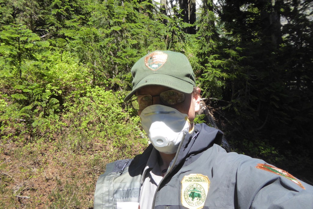
For most of my adult life, I worked as a park ranger at several different national parks. And, if you’re a ranger you are bound to deal with poop at some point, sometimes often. I’ll spare you the details of my dirtiest national park human waste story (pro tip: avoid the handrails in Carlsbad Cavern). Yet, I want to take the opportunity to discuss what a backcountry ranger might deal with during their day on a trail. Take a short journey with me to North Cascades National Park.
In 2017, I was fortunate enough to work in North Cascades, one of the more rugged national parks in the contiguous 48 states. Once every two weeks, I was assigned a three to five night backpacking route through the park and adjacent national recreation areas to assess trail and campsite conditions, make minor trail repairs, check to see that people complied with park rules, and generally ensure that people were having a good experience. I enjoyed those trips, especially the evenings when work was finished and I could relax at a secluded campsite looking at trees and watching for wildlife.
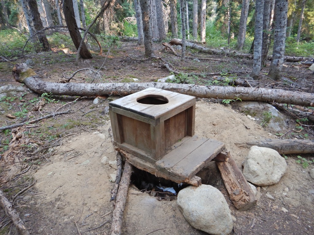
North Cascades is cherry-stemmed with a well-maintained, extensive trail network and almost every trail is dotted with a few backcountry camps. The luxuries of each camp vary—some are little more than a dirt tent pad—but one thing you can count on is some sort of toilet. Except at boat-in sites and some high elevation camps, most are simple privies consisting of a box over a hand-dug hole in the ground.
A privy box sits above a too large hole at Fireweed Camp in North Cascades National Park. Once filled to capacity a ranger or, more often, the trail crew digs a new hole nearby and moves the box seat over it or replaces it with a new one.
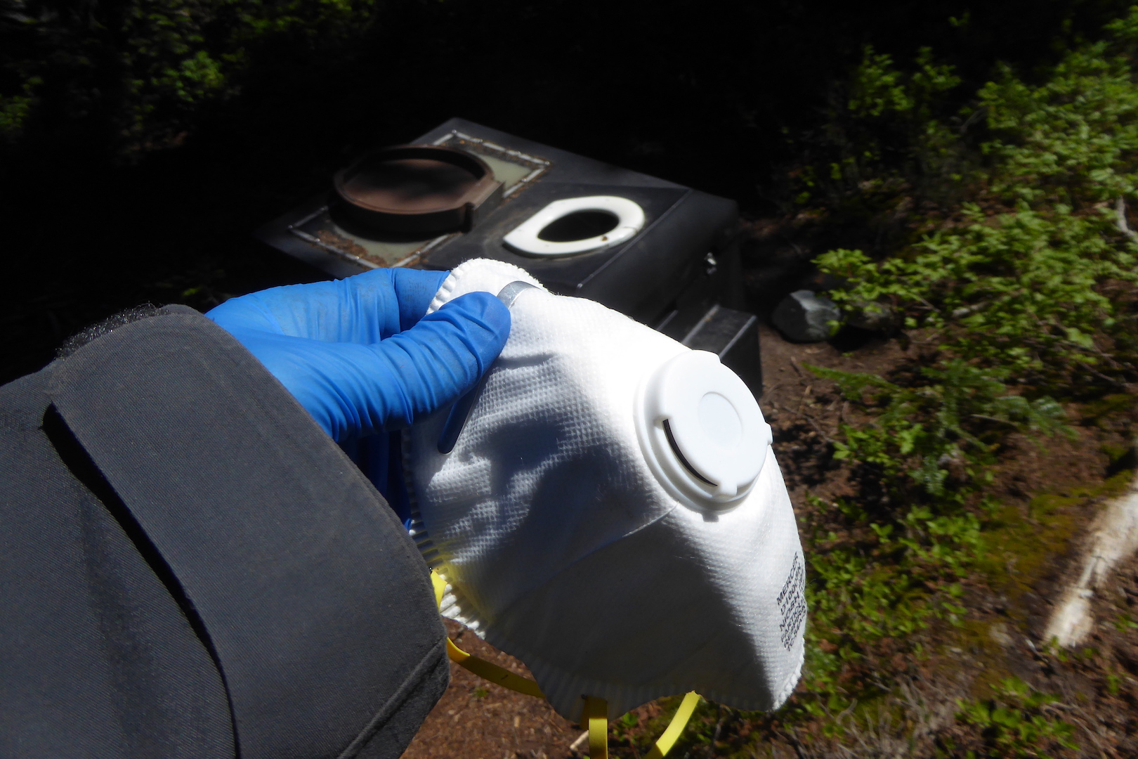
Checking toilets was a frequent duty on the trail. I would glance into every backcountry privy and assess its condition, which meant I looked into a lot of toilets during a typical multi-day trip. Most didn’t need attention, thankfully. Yet I always approached slowly, mentally prepared to encounter unpleasant conditions in need of remedy.
Along Brush Creek at the isolated Graybeal Camp—on the third day of a five day hike that previously included stirring a composting toilet and bagging up human waste deposited inappropriately on the surface of the ground adjacent to a tiny stream—I arrived to find the privy nearly full to the brim. Faced with such situations, there are various tricks one can use to increase a privy’s capacity. For example, a ranger I knew would use using a long, stout branch to knock over the cone of feces and toilet paper deeper into the privy hole at a heavily used site, perhaps prolonging the need to dig a new hole for a couple of weeks. In this case at Graybeal though, there appeared to be no room at the inn.
Graybeal Camp is lightly used compared to more popular destinations like Ross Lake, Cascade Pass, Sahale Arm, and Copper Ridge. Only a few weeks remained in the hiking season when I arrived in late August and many feet of snow would soon bury the camp for the winter. But this camp needed a new privy hole and I couldn’t in good conscience pawn the problem off on another ranger.
I located the trail crew’s cache of tools at a nearby group site and prepared to dig a new hole and move the toilet to it. That is, until I realized there was a risk of disturbing something I shouldn’t.
The places we call national parks were never unpeopled and areas that we consider good campsites today were also likely to have been used by indigenous peoples. I didn’t know if park archeologists had inventoried the campsite for artifacts or even assessed the potential for them. The last thing I wanted to do was disturb an archeological site for a lowly hand-dug privy hole.
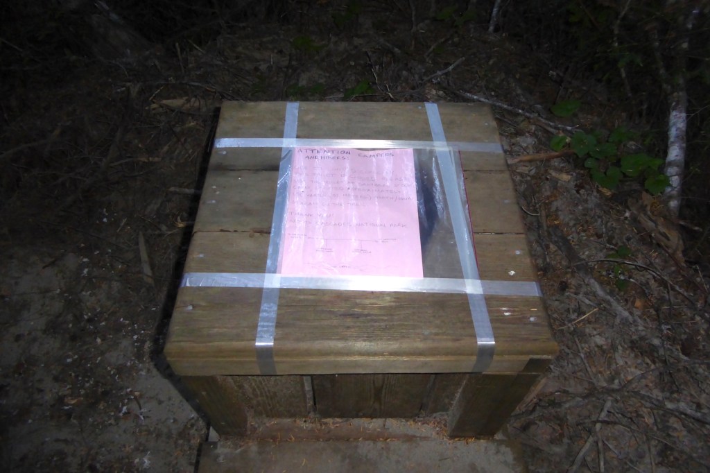
After I confirmed with the backcountry office that archeologists did not clear the site for digging, I needed another plan. The tool cache had a roll of fiberglass tape. I carried a re-sealable plastic freezer bag, some paper, and a pencil. So I wrote a note closing the toilet “due to limited capacity,” placed it in the bag, and taped it over the toilet hole.
Was this a satisfactory solution? Not at all. I had, unfortunately, pawned the work off to other park staff. But, it kept people from pooping on the ground* and the toilet at the group campsite was relatively close, so the risk of human waste proliferating everywhere was minimal.
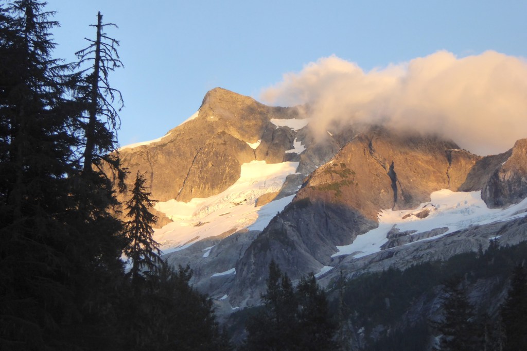
*People were, in fact, pooping on the ground. Unbeknownst to me (I had not been to that campsite before), the trail crew later discovered that a flash flood had washed the toilet off its hole and placed it directly on the ground in the forest. What I thought was a mound of human waste extending a few feet into the earth was merely a foot tall mound of human waste sitting on sandy outwash.Alpenglow on Whatcom Peak as seen from Graybeal Camp.
Privies work well at relatively low elevation, forested sites if use isn’t heavy and moderate levels of decomposition can work its magic. But what to do in places that are too dry, too cold, too rocky, or too well trodden to for a traditional privy to work?
That’s the issue that Rocky Mountain National Park rangers deal with on the route to Longs Peak, and why they chose to utilize a new toilet design. Still, I am aware of no backcountry toilet that doesn’t require some maintenance. When the vaults on the toilets at Longs Peak are full, then the waste must be flown out by helicopter. Many other high-elevation backcountry toilets require more labor.
There are many backcountry sites within North Cascades where a simple privy won’t work, so for many years the park has used a type of above-ground composting toilet.
A compositing toilet at Pelton Basin.
For these to work well, though, the toilet can’t be used too frequently, the contents can’t get too wet with urine or precipitation, the dry-matter to human waste ratio can’t skew too much toward feces, and they should be stirred regularly to promote composting. A full toilet requires someone to shovel the contents into a drum that can be flown out by helicopter.
Dealing with composting toilets was one of the more unpleasant tasks during my time in the backcountry. Excessive moisture often prevented composting, so they were often filled with a festering sludge. After a trial-by-fire experience stirring one for the first time, I found that slow, deliberate movements as well as covering as much of my skin as I could were necessary safety precautions when maintaining this style of toilet. There is a real risk working around a vat of human feces, especially when you are more than a day’s hike away from the trailhead.
Long sleeves? Facemask? Disposable gloves? Some sort of eye protection? Check.Ready to stir. Remember the days when N95 masks didn’t need to be rationed? Good times.
I’m not complaining about the toilet work. Because, honestly, looking at a few turds each day isn’t that bad in the scheme of things. I’d do it again without complaint, accepting it as a necessary duty so that less human waste pollutes our parks. People gonna poop and the urge doesn’t always strike us at convenient times or places. However, as visitation continues to increase in many national parks, the burden and hazards of human waste grows too, in both easily accessible places as well as remote backcountry locations.
If you visit a national park (and, really, consider postponing your trip while COVID19 rages), you could personally thank the park staff for the work they do to. However, a more rewarding thank you would be to do your part keep wild areas and parks clean.
North Cascades was long considered a hidden gem of a park; one in which you could go on a summer weekend and find a place to camp fairly easily. Since its establishment in 1968, however, the population of Washington State has more than doubled. Mountaineering, hiking, skiing, and backpacking are more popular than ever. Millions of people live only a two to three hour drive from Washington’s iconic national parks and national forests. These destinations, however, operate with essentially the same number of campsites that they did in the 1970s. The North Cascades park complex (including Ross Lake and Lake Chelan National Recreation Areas) is no longer a place where you can expect to easily find a campsite on summer weekends. Finding a campsite is even becoming increasingly difficult on weekdays.
As we approach and exceed the carrying capacity of developed areas of parks, then increasing numbers of people spill into areas that have been traditionally off the beaten path. We bring our waste and waste issues with us. National parks, forests, and other recreational areas are increasing challenged to meet the demands posed by current levels of visitation. Turds included.
I first traveled to Brooks River within Katmai National Park in early May 2007, and today it’s hard for me to imagine my life without it.
On the morning of my first flight to Brooks Camp (which is only accessible by boat, plane, or a very long, boggy, buggy, and rough cross-country hike), fellow rangers and I hauled our clothing, equipment, and months of food to the floatplane docks along Naknek River in the small town of King Salmon, a sprawling community surrounding an airport and mothballed U.S. Air Force base. We were excited and enthusiastic to begin the adventure, but few of us, I believe, truly understood what we were getting ourselves into. I certainly didn’t. Not quite a greenhorn when it came to wild areas, I had never experienced a landscape like this.
Immediately after takeoff, I gazed out the window of our small plane, my eyes transfixed on what many people would describe as nothing. King Salmon’s few houses, roads, and infrastructure quickly yielded to tundra and scattered spruce trees. This was land devoid of permanent human habitation. Cross hatching animal trails led to unknown destinations. I saw wildly meandering creeks, too many ponds and lakes to count, and a horizon bounded by unnamed mountains.
After twenty-five minutes of flying, the pilot landed smoothly on Naknek Lake’s calm surface, and we taxied to an empty beach in front of the few scattered buildings marking Brooks Camp. With the help of fellow staff, I hurriedly unloaded and stashed my gear inside a nearby tent frame cabin and began to settle in.
Later that evening, Jeanne, my then girlfriend and now wife, and I returned to the beach. I had just finished a winter job at Death Valley National Park, where daily temperatures had already risen above 100˚F, but Brooks Camp looked like winter couldn’t decide to stay or go. Leaves had not broken bud, thick blankets of snow clung to the mountains, and the underground water pipes to our cabin remained frozen. I walked wide-eyed, trying to take in the totality of the scene—the turquoise color of Naknek Lake, the snow-capped mountains, the pumice-strewn beach, a set of bear prints in the sand—when Jeanne waved her arm toward the horizon and remarked, “This is spectacular.”
I don’t recall if I responded or not. Doesn’t matter, because she was right. I had never looked upon land so empty yet so full.
Katmai and Brooks River are unlike any other place. But relatively little has been published about the bears, salmon, and humanity that intertwine at the river. In 2014, I first imagined an idea of writing a book about Brooks River and its inhabitants. In 2016, I began to work on it in earnest and this year I finished the manuscript. I’m pleased to announce my book, The Bears of Brooks Falls: Wildlife and Survival on Alaska’s Brooks River, is available for pre-order. It ships out in March 2021 via Countryman Press. In eighteen chapters, the book strives to explore the ecology of the river’s famed brown bears and salmon as well as the complex relationship people have with the place.
Part one focuses on the colossal eruption of Novarupta Volcano in 1912 and the discovery of the Valley of Ten Thousand Smokes. This event reshaped the area’s history and led to the establishment of Katmai National Monument in 1918, a time when the national park idea was still fledging.
Today, Katmai is most famous for its brown bears. Part two is devoted to their lives and the salmon the bears depend on to survive. I explore the marvel of the hibernating bear from a den on Dumpling Mountain, discover the river from a cub’s perspective, and follow the tribulations and growth of young bears recently separated from their mother. The brown bear mating season provides the chance to learn how bears compete during one of the most important times in their lives. Writing about the bear hierarchy, I consider how this social structure provides advantages to bears who live in an unfair world. Katmai’s brown bears experience hunger in a profoundly different way than people. They must eat a year’s worth of food in fewer than six months to survive hibernation. Their feeding choices and habits reflect highly tuned adaptations to take advantage of summer’s ephemeral bounty. And, the poignancy of a cub’s death, one witnessed by thousands of people on the park’s webcams, provides the chance to reflect on the end of a bear’s life.
Few organisms are as important to an ecosystem as salmon are to Katmai. Leading Odyssean lives, sockeye salmon face tremendous obstacles and challenges. From fresh water to the ocean and back again, they travel thousands of miles, running a gauntlet of predators to fulfill their destiny. Weakened by their freshwater migration and subsisting without food for weeks, the journey of Brooks River’s sockeye ends when they sacrifice their lives to reproduce. They are the ecosystem’s keystone, driving the river’s abundance and significance.
In part three, I examine modern humanity’s influence over Brooks River. Humans may be the river’s biggest ecological wildcard. Climate change looms large over the land and seascapes, and people alter the behavior of the bears that make the scene so special. The infrastructure needed to support thousands of visitors and their recreational activities invite conflict with bears. Managing bears and people in such a small area is especially challenging, provoking a decades-long and often emotional debate about the river’s future.
The Bears of Brooks Falls: Wildlife and Survival on Alaska’s Brooks River is an exploration of brown bears and salmon in one of the Earth’s last fully intact ecosystems. It’s an honest and deep dive into issues surrounding the role people play in the riverscape and Katmai National Park. And, I’m so excited for you to read it, and I hope you’ll consider adding it to your bookshelf.


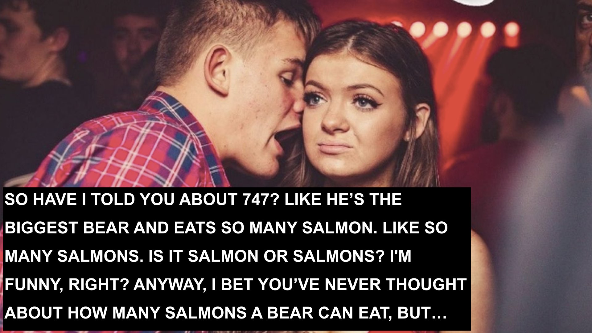
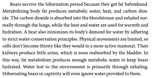


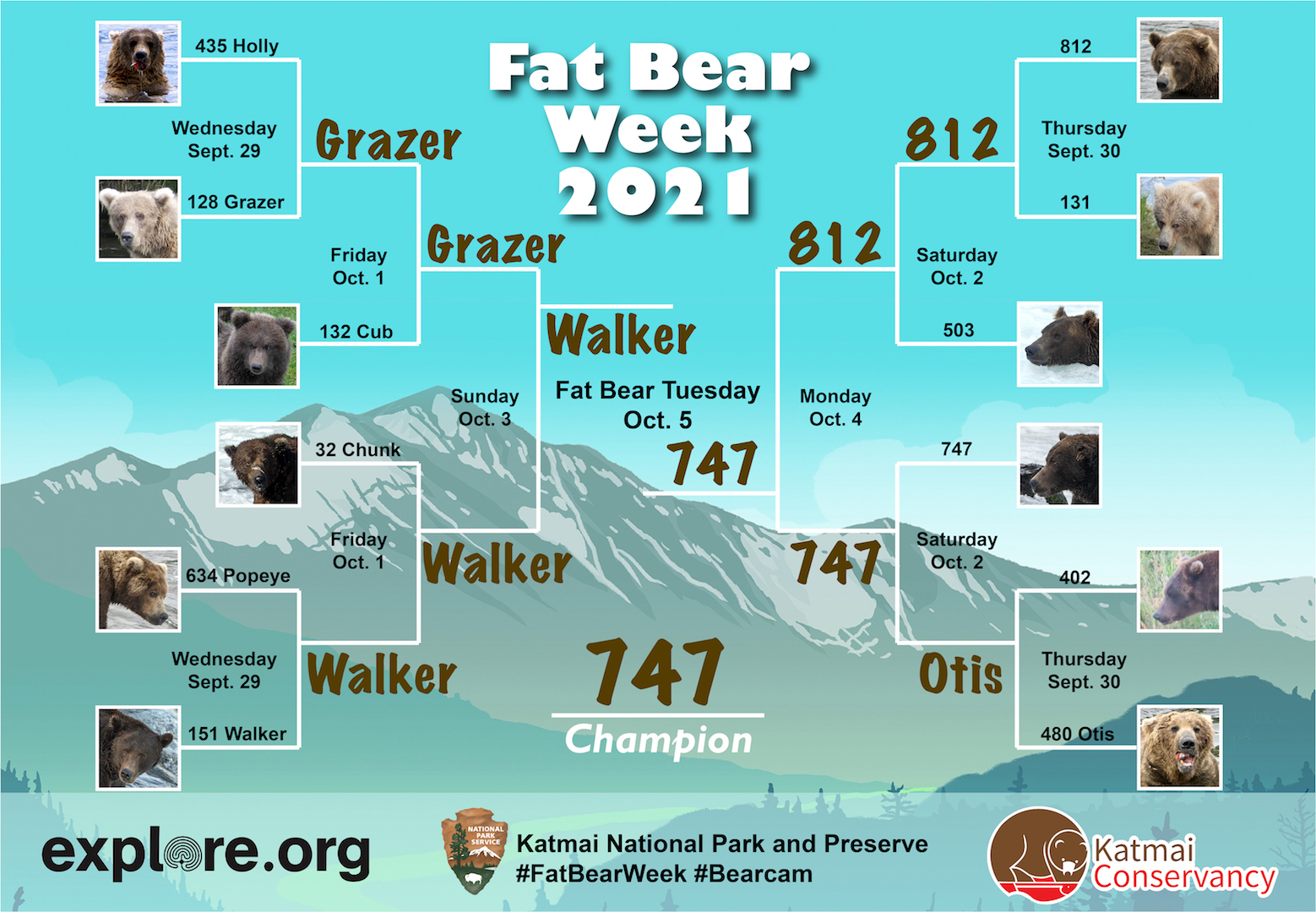
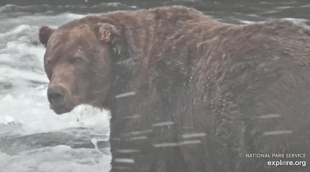
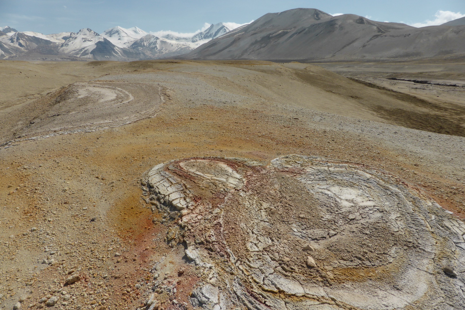
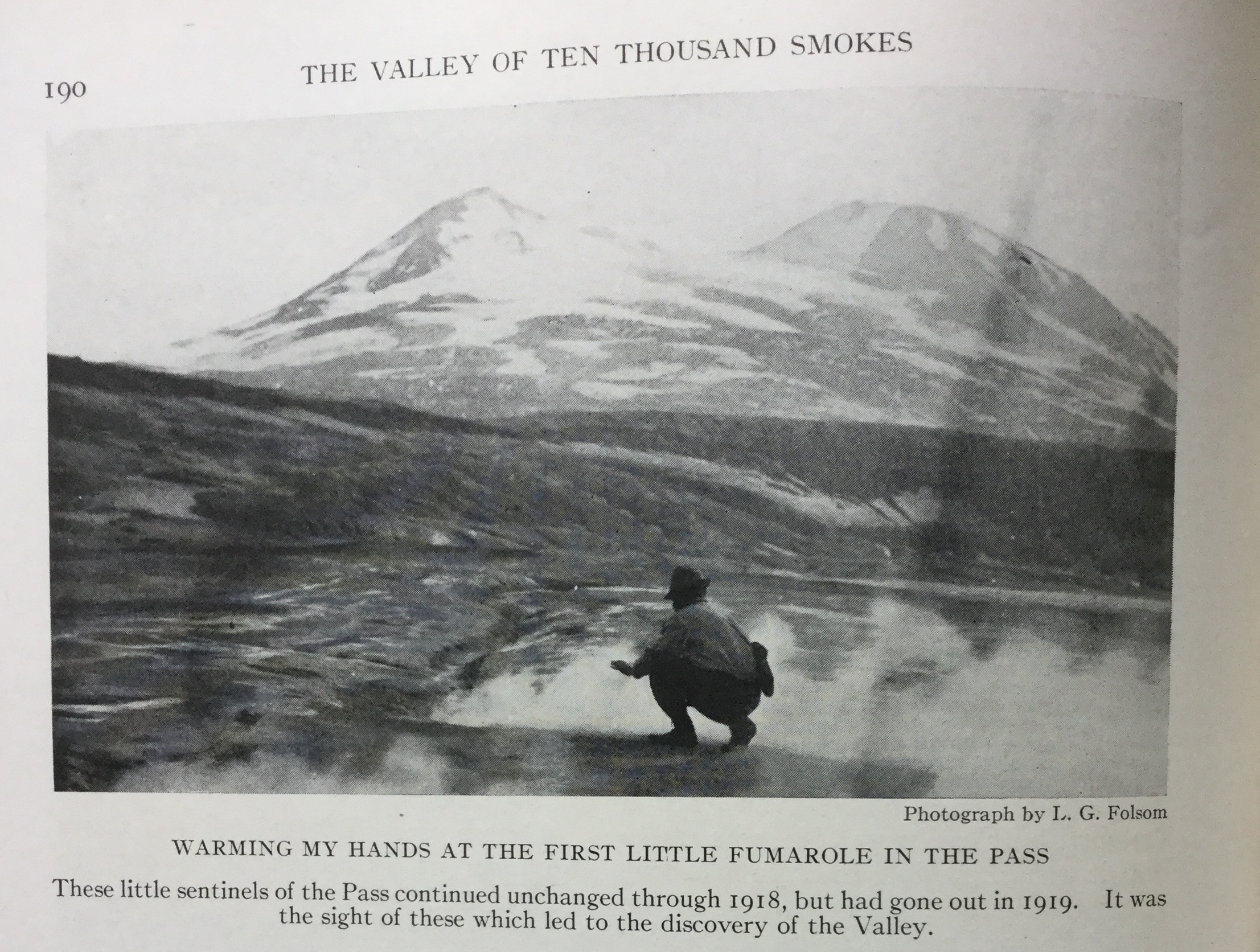
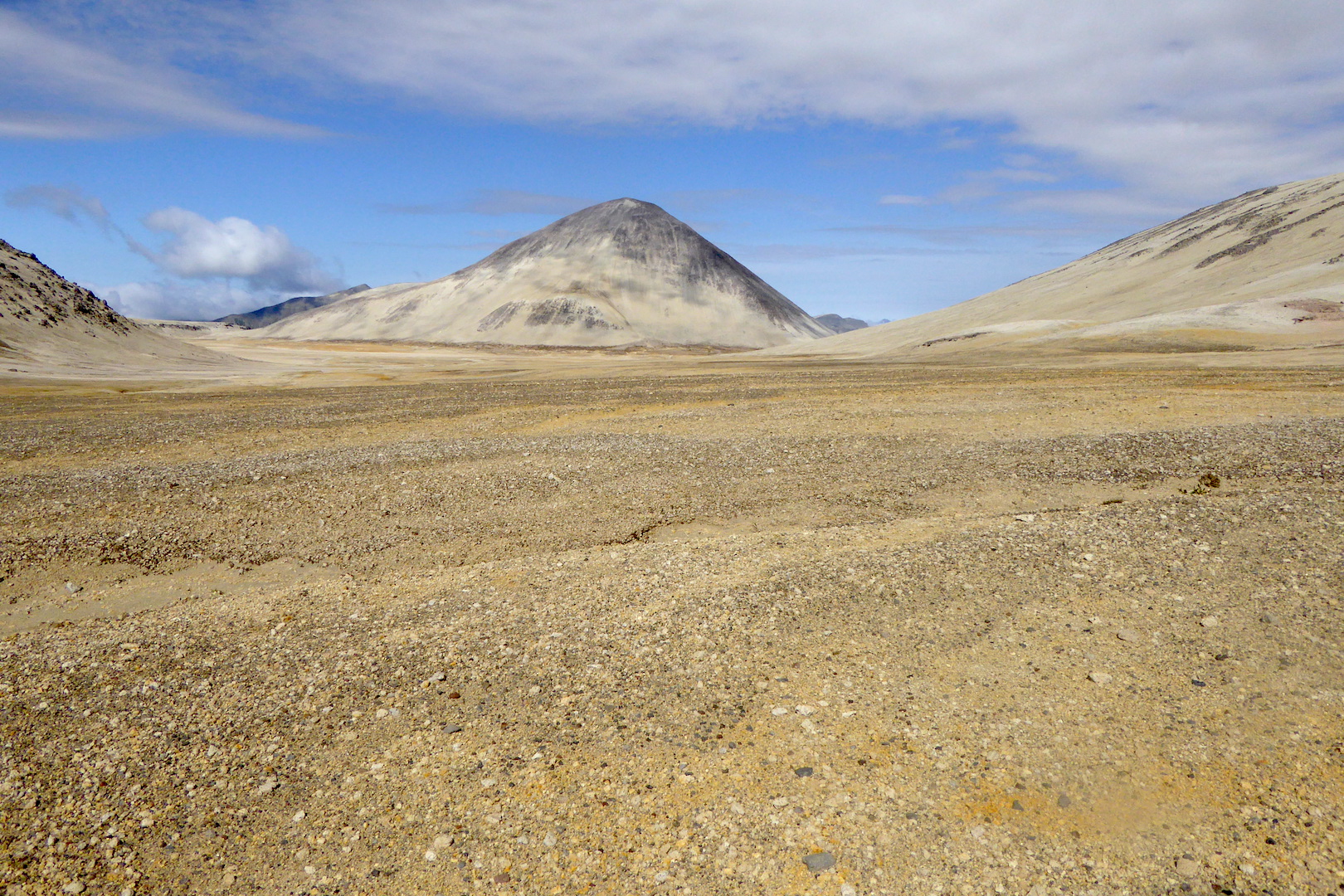
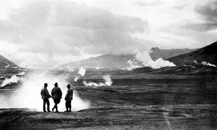
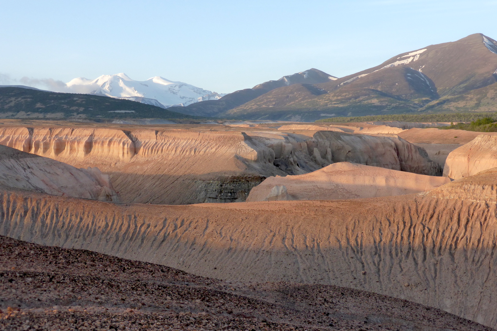


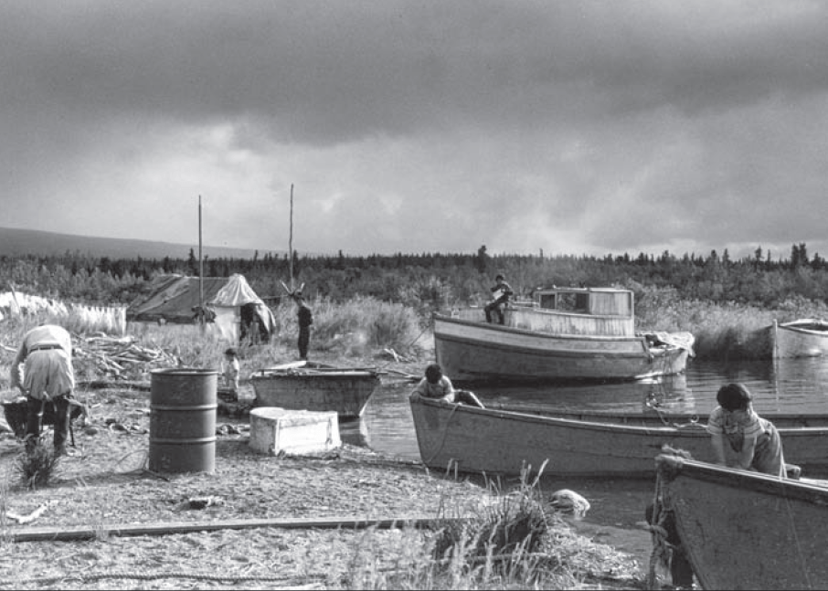
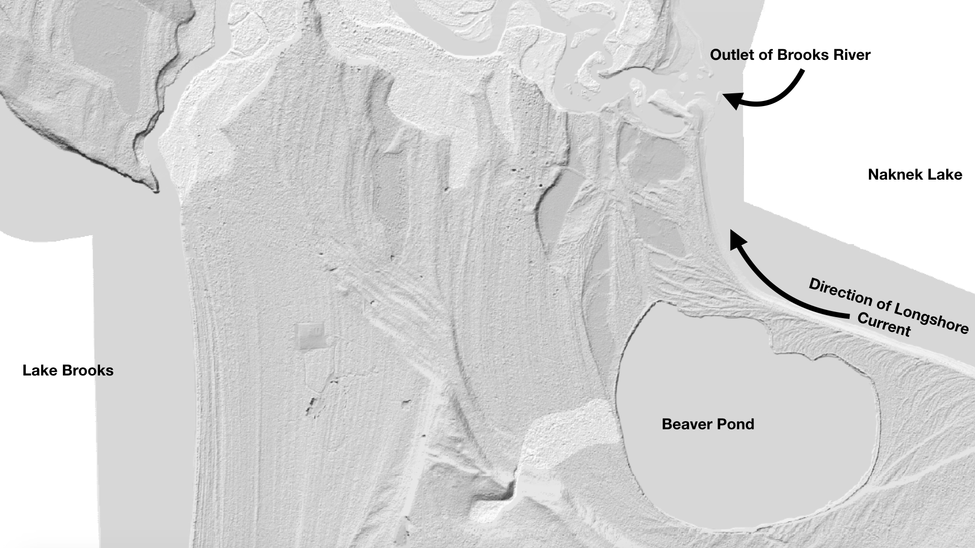
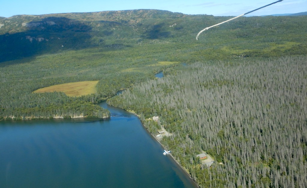
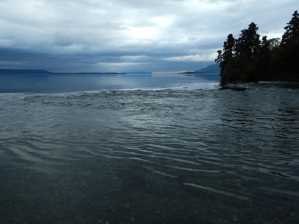


![Screen shot of youtube comment. Text says, "Gladhe 1 month ago He protecc He attacc He most importantly Eat big mac!]](https://fitznaturalist.com/wp-content/uploads/2021/01/screen-shot-2021-01-22-at-9.03.55-pm-1-e1611675551409.png)