In the Salt Marsh

Along the Atlantic Ocean and Gulf of Mexico, from Newfoundland to Florida, you can find a special habitat—the Spartina salt marsh. A transition zone between the land and the sea, this is a challenging place to live for many organisms. I found myself with some spare time while visiting family in South Carolina, so of course I couldn’t resist exploring a nearby salt marsh, one of the most productive ecosystems on Earth. This habitat produces more biomass per meter than almost any other biome. Only tropical rainforests are more productive.

brown grass in salt marsh meadow

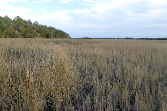
A typical salt marsh scene in winter: golden-colored cordgrass.

I reached the marsh near low tide, which exposed soggy ditches and mud flats. The mud was soupy in places, sucking at my boots.

Looking down on boots in soupy, dark brown mud.

Oysters clung together in the lowest reaches of the tidal flats and ditches. The tips of their shells may be fragile, but they are also extremely sharp, as sharp as a surgeon’s scalpel. I don’t know whether the shell’s sharpness is an accident of evolution or an adaptation to protect them from predators like drums, rays, and clumsy humans like me. I do know that I’ll never forget the first time I tried to walk over a few oysters while only wearing flip flops. Trust me, it’s not a pleasant experience.

oyster shell with sunlight passing through translucent upper portion of shell.

The edges of many oyster shells are thin and fragile, but also very sharp.

Walking was easier where vegetation was firmly established. On the U.S. Atlantic coast, most salt marshes are dominated by Spartina grasses. There are several species of Spartina, but the most abundant is salt marsh cordgrass (Spartina alterniflora). Cordgrass thrives in this habitat, despite the harsh conditions—flooded twice-daily by tides, exposed to high salinity, and mired in anoxic (oxygen-free or oxygen-limited) mud.

golden brown grass, trees seen on horizon

Salt marsh cordgrass is the most abundant and ecologically important plant in East Coast salt marshes.

Most flowering plants have a fairly low tolerance for salt, but the cordgrass is watered by the ocean twice a day. Cordgrass meets the salty challenge by sequestering salt in its shoots and excreting the salt through glands in its leaves. The grass deals with the challenge of low oxygen levels in the deep mud by exchanging gases from roots in the upper few centimeters of mud to those underneath. Few plants have these dual abilities, which is the reason cord grass so thoroughly dominates salt marshes. Once you learn to identify salt marsh cordgrass, you can easily and accurately judge the average level of high tide, since cordgrass is usually limited to areas that receive substantial flooding with each high tide.

brown grass of salt marsh, taller rushes on left of photo, trees on horizon

The transition between the low marsh to the high marsh is marked by plants other than salt marsh cordgrass. The high marsh lies above the typical high tide line. Plants like black needlerush (Juncus roemerianus), salt meadow hay (Spartina patens), salt grass (Distichlis sp.), and saltwort (Salicornia sp.) begin to compete with cord grass where tidal flooding is less frequent. Needlerush is the taller plant on the left of the photo.

pinkish, segmented stem of saltwort

Saltwort is a noticeable member of the mid to high marsh community.

Unlike salt marsh cord grass, saltwort tolerates high salt levels through its ability to retain water in its stems, but it cannot withstand the same level of submersion that cordgrass can. Saltwort always captures my attention though, not only because it is a pretty plant, but because it is tasty. Late December is not a choice time for nibbling on saltwort stems. Few were even standing, but the sight of them reminded me of their pleasing salty bite. (I’ve also pickled saltwort using a recipe I found in a Euell Gibbons book. It tasted surprisingly good.)

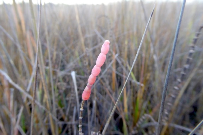
Before leaving the marsh, I took some time to watch birds out on the lower fringes of the exposed mud. A casual scan through binoculars revealed over a hundred semipalmated plovers. On the edge of the marsh, these birds work to survive the winter before returning north to their breeding grounds from Newfoundland and Labrador west to Alaska.They were also finding a few more invertebrates than I was.

shorebird pulling a worm out of mud with its bill

Worms are yummy for plovers.

My urge to get a little closer to the exposed mudflats brought me to the edge of the cord grass where the mud was very soft. While plovers were pulling invertebrates out of the mud, I was having some difficultly extracting my boots from the mud. Salt marshes are challenging places to live and, if you’re human, difficult places to travel.

looking down on very muddy pants and footware

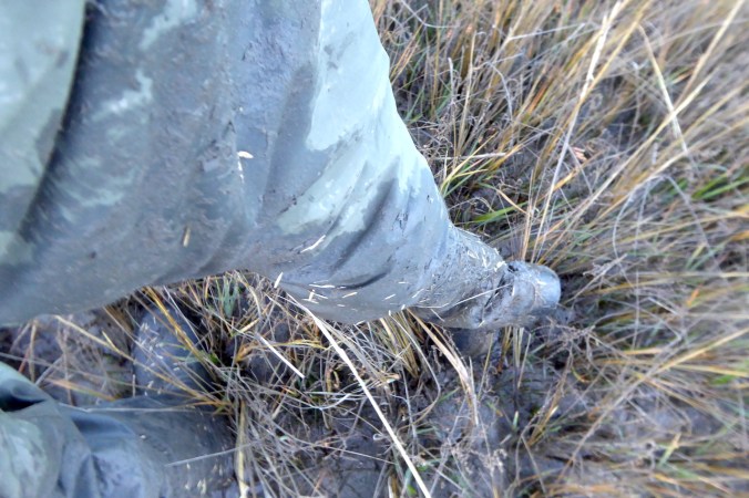
Salt marsh trekking is dirty business.

Earth Time Lapse

Nothing is completely static on geologic timescales, but some features—like volcanoes, barrier islands, glaciers, and human development—change faster than others. To see these changes, I’ve been playing around with Google’s Earth Engine. By combining over 30 years of Landsat imagery it offers a remarkable look at how Earth’s surface has changed recently. I found reason for concern, but was reminded just how beautiful the planet is.

Volcanoes

Volcanoes are the most dynamic landforms on Earth. While the above GIF’s imagery starts a few years after Mount Saint Helen’s 1980 eruption, it captures the volcano’s awakening from 2004-2008 when a large lava dome grew in the crater. Very cool.

Surtseyan eruptions are island forming eruptions that happen in shallow water. In 2011 and 2012, you can see new islands suddenly appear on the sea’s surface in the Zubair Group, volcanic islands in the Red Sea. Few people have seen new islands form, but there they are. Super cool.

Barrier Islands

Barrier islands move, often rapidly. Toms Cove Hook is protected as part of Assateague Island National Seashore and Chincoteague National Wildlife Refuge. Unlike most barrier islands on the Atlantic coast of the U.S., Assateague is almost free of permanent structures and roads. Toms Cove Hook has no development at all. Here is an increasingly rare opportunity to watch a barrier island dance. Beautiful.

Fire Island is a national seashore off of Long Island in New York. Before the 2012 breach, watch the sand slowly creep across the island. Barrier islands move shoreward when sea levels rise. They are not permanent features. When allowed to move naturally I find these islands exceptionally beautiful, but they are no place for permanent roads or structures. It’s human folly to build on these islands. They simply change too quickly.

Glaciers

Carbon Glacier carves the north slope of Mount Rainer. Worldwide, glaciers have undergone significant declines over the last 30 years and Carbon Glacier is no exception, but that doesn’t mean glaciers still don’t flow downhill. Even receding glaciers continue to erode the land as Carbon Glacier demonstrates. It carries sediments downhill in a conveyor belt-like manner while its terminus shrinks. I find a glacier’s flow mesmerizing.

Human Development

This is, sadly, probably the easiest example of rapid change to find on Earth today. Cranberry Township, Butler County, PA is a typically example of the development much of the U.S. has experienced in my lifetime. I grew up about 20 miles north of here and witnessed its semi-rural farmland transform into a maze of tract homes and strip malls.

That rainforest destruction I heard about as a kid really hasn’t abated either. GIF showing destruction of Amazon rainforest

Who knew it would be so easy to watch decades of change? Tools like the Earth Engine are amazing and they allow me to see the world like never before. As I browsed I was awed by power and beauty of natural changes and saddened by the rate humans are altering the planet. Hopefully, we can use information like this to inspire everyone to protect what we have left.

Brooks River Bears Need Your Help

two sleeping bear cubs

402’s spring cubs rest near the Lower River Platform at Brooks River on October 24, 2013.

Addendum: Please read the response to this issue by Katmai’s Superintendent, Mark Sturm.

In 2017, an elevated bridge and boardwalk will be constructed at Brooks River. In this post, you’ll find a letter that asks Katmai National Park to further restrict the timing of staging and construction for the bridge. My reasoning is outlined in the letter. I wrote it because I believe no staging or work on the project should happen from late June to late July or September and October. Brooks River’s bears, especially those who are not habituated to people, need complete access to the lower river area in the fall. That is their last chance to gain weight before hibernation. The current work schedule allows staging and work to begin when bears need Brooks River most. This is not acceptable.

You are welcome to use the letter to contact the park. You can use it as is, or personalize it as you see fit. You can copy the letter’s text below or download the rich text file which can be used with almost all word processing software.

Before you contact Katmai with your thoughts, please consider the following…

  • The construction dates for the bridge project are in a federal contract which has already been awarded. If the dates can be modified it won’t be a simple process since it’s currently a contractual obligation. Don’t expect any change, if it comes, to be quick.
  • Form letters are easy to respond to, because the recipient only needs to write one response. Personalized messages often require more in-depth responses.
  • Phone calls can be more effective than written correspondence.
  • Be polite and respectful when you contact the park. The people who manage Katmai are intelligent and well-meaning. They do not deserve insults or personal attacks.

You can contact the park in several ways.

And now the letter:

Superintendent Sturm,

As you know, an elevated bridge and boardwalk will be constructed at Brooks River in 2017. The summary of work outlined in the project’s construction specifications generally restricts work and staging of equipment and supplies outside of July. Yet, it places minimal restrictions on staging and construction in late summer and fall. This will have serious impacts on bears who need full access to the river in September and October. I urge you to reconsider the construction schedule and modify the current contract to minimize the project’s impact on bears.

The construction schedule allows work in the river corridor to commence as soon as October 1. Work hours outlined in the construction specifications also permits staging on the spit at the mouth of Brooks River anytime after August 1. These activities can potentially displace many bears from the lower river, especially those who are not human-habituated.

Dozens of brown bears gather at Brooks River throughout September and October. The fall feeding period is especially critical, since bears are hyperphagic and need access to Brooks River’s abundant salmon. The river mouth provides salmon catch rates far higher than other areas of the river. Additionally, many bears who use the river in the fall are not habituated to people or vehicles. Habitat use by these bears is already restricted by the presence of people. Staging and construction in the fall will further displace these animals. Impacts to wildlife and the visitor experience from staging and construction of the bridge is of short duration, but can potentially be serious for individual bears who need to utilize the river. Bears that feed at Brooks River may do so because they know of no other or better place. For them, salmon in Brooks River ensures their yearly survival.

I understand that water levels in Naknek Lake provide a narrow window to transport materials and supplies to Brooks River, and often this can only occur in mid to late summer. However, this does not justify displacing bears from the food resources they need to survive, even for one season. Brooks River is a world famous bear viewing area. In FY16, the bearcams received 40 million hits. Brooks River’s wildlife deserves the highest level of protection possible. To do this, I urge you to place further restrictions on the construction schedule for the elevated bridge at Brooks River. Staging should only occur outside of July and September-October. Construction and clearing work in the river corridor should begin no sooner than November 1.

I look forward to your response and thank you for your time.


Addendum: Please read the response to this issue by Katmai’s Superintendent, Mark Sturm.