The Difference Between Brown and Grizzly Bears

For my book on Brooks River’s bears and salmon, I find myself digging deep into natural history and ecology of brown bears. Sometimes I uncover research that challenges my long held assumptions. Take the difference between brown and grizzly bears, for example; something I often said was mostly based on geography and diet. As I wrote for Katmai’s website:

All grizzly bears are brown bears , but not all brown bears are grizzly bears. Grizzly bears and brown bears are the same species (Ursus arctos), but grizzly bears are currently considered to be a separate subspecies (U. a. horribilis). Due to a few morphological differences, Kodiak bears are also considered to be a distinct subspecies of brown bear (U. a. middendorffi), but are very similar to Katmai’s brown bears in diet and habits.

Even though grizzlies are considered to be a subspecies of brown bear, the difference between a grizzly bear and a brown bear is fairly arbitrary. In North America, brown bears are generally considered to be those of the species that have access to coastal food resources like salmon. Grizzly bears live further inland and typically do not have access to marine-derived food resources.

These geographic and dietary distinctions seem simple enough. However, there is little scientific evidence to support it. Both brown bears and grizzly bears exist, but the differences between them aren’t what I had long assumed.

bear grazing on vegetation with travertine and forest in background

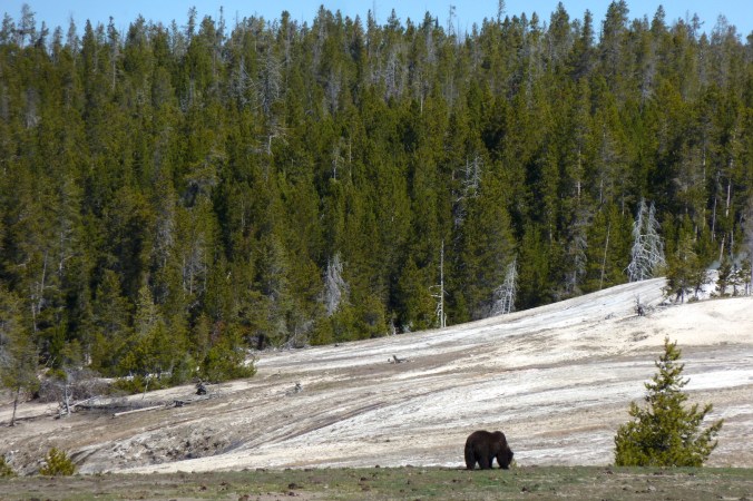
A grizzly bear grazes on springtime vegetation near Old Faithful in Yellowstone National Park.

bear in water

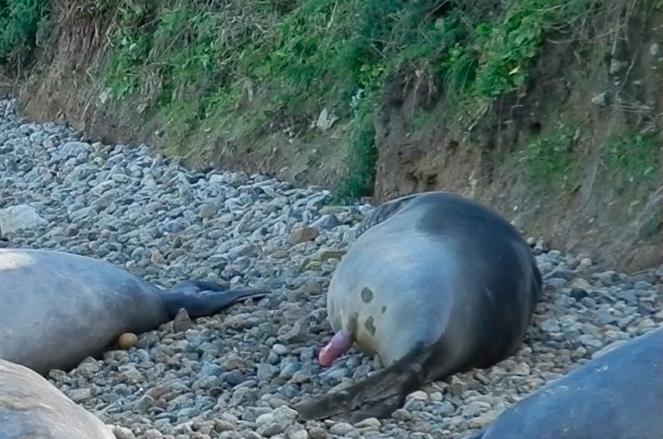
A brown bear at Brooks Falls in Katmai National Park. (NPS Photo)

Although North American brown, grizzly, and Kodiak bears belong to the same species, Ursus arctos, bear taxonomy underwent many revisions before scientists reached this conclusion. In the nineteenth and twentieth centuries, taxonomists frequently lumped and split brown/grizzly bears into many different species and subspecies. The separation peaked in 1918 with the publication of C. Hart Merriam’s Review of the Grizzly and Big Brown Bears of North America in which Merriam proposed around 80 (not a typo) species and subspecies of North American brown bears. Taxonomists like Merriam relied on morphological characteristics that could be seen or observed to classify living and extinct organisms. Warm-blooded animals that have hair, breathe air, and produce milk for their offspring are mammals, but warm-blooded and air-breathing animals that lay eggs, have feathers and toothless beaks are birds. These are greatly simplified examples, I realize, and such tidy and clear distinctions aren’t necessarily common in nature. They often become more difficult to resolve at the genetic and species level, especially in cases of hybridization or when taxonomic distinctiveness is based on subtle physical differences.

Merriam’s nuanced classifications of brown and grizzly bears were based on differences in skull morphology and dentition, characteristics he examined painstaking detail. Among taxonomists, Merriam was a splitter. On southeast Alaska’s Admiralty Island alone, he classified five distinct species . In the Katmai region, Merriam described two species, Ursus gyas for the Alaska Peninsula and Ursus middendorffi for Kodiak Island , as well as others for bears living in the Cook Inlet area and on the Kenai Peninsula.

If you think his classifications of brown/grizzly bears was a little over the top, you’re not alone. Merriam foreshadowed opposition to his conclusions when he wrote in his Review, “The number of species here given will appear to many as preposterous . To all such I extend a cordial invitation to . . . see for themselves.” And they did. Most of the species or subspecies described by Merriam were later regarded as local variations or individual variants. While all of Merriam’s species have since been lumped together as U. arctos, in the mid 1980s as many as nine extant or extinct subspecies of U. arctos were recognized in North America , but the only names for North American brown bear subspecies in still widely used are U. a. horribilis, the grizzly bear, and U. a. middendorffi, the Kodiak bear. Recently, however, even these classifications have come under question.

In hindsight, it’s easy to scoff at Merriam’s conclusions. Could there really be dozens of brown bear species in North America? Within the methodologies and knowledge of his era, his results aren’t that far fetched. Little was known about the behavior, growth rates, ecology, and population dynamics of North American bears in the nineteenth and early twentieth centuries. Given access to the same tools and information as modern taxonomists, Merriam may have discovered grizzly and brown bears can’t be so easily divided by differences in skull and tooth shape.

Ursus arctos is one of the most widely distributed mammal species on Earth. Historically, brown bears were found from the British Isles south to North Africa and east across northern and central Asia to Alaska and most of western and central North America. Two to three million years ago, they split from a common ancestor shared with black bears . The oldest brown bear fossils are from China and date to about 500,000 years ago. By 250,000 years ago, they spread to Europe. During the last 100,000 years of the Pleistocene, bears immigrated and emigrated across much of the northern hemisphere as climate and habitat dictated. When continental ice sheets advanced, available habitat shrunk and bears became isolated into separate populations. When the ice receded, bears dispersed into the new territory. Beginning around 70,000 years ago, the first brown bears moved into North America. While we know when and where bears lived and live from fossils and historical records, this doesn’t necessarily deduce the genetic relatedness of modern populations.

Phylogeography is a branch of phylogeny, the evolution of an organism or group of related species or populations. As such, phylogeography traces the distribution of genetic variation through time and space. In this regard, mitochondrial DNA (mtDNA) is especially useful to track female ancestry. MtDNA  resides in the mitochondrion, a cell’s powerhouse, and is inherited from the mother only, unlike nuclear DNA which is a recombination of genes from both parents. According to mtDNA analysis, there is no divide between brown and grizzly bears based on an animal’s relationship to the coast or marine food sources, nor does it support the status of U. a. horribilis or U. a. middendorffi or any other historical subspecies in North America. The only historic classification that holds is at the species level—Ursus arctos. Instead, matrilineal ancestry suggests brown bears in North America fall into three main clades.

  • Mainland Alaska, Kodiak Archipelago, and northwest Canada.
  • ABC Islands (Admiralty, Baranof, and Chichagof) in southeast Alaska.
  • Southwestern Canada (Alberta, British Columbia) and the lower 48 States.

Clades are groups of organisms evolved from a common ancestor and consequently share a genetic relationship. The three North American clades, as well as others in Europe and Asia, are believed to be descended from brown bears living in isolated populations in Asia during the late Pleistocene . Since then, the mtDNA has remained geographically separated due to the tendency of female brown bears to be homebodies. Female brown bears are philopatric. They tend to remain near or have partly overlapping home ranges with their mother and do not rapidly invade areas already occupied by other brown bears . This can prevent or at least greatly slow mtDNA from mixing into other bear populations, even long after significant barriers like ice sheets have disappeared.

screen capture of Earth with clades of bears outlined.

Approximate range of brown bear clades in North America based on mtDNA. Different clades are represented by horizontal and vertical lines. The solid red circle marks the location of brown bears on the ABC islands.

Bears on the ABC Islands are the most genetically distinct of all Ursus arctos. Their mtDNA aligns them more closely to polar bears than to other brown bears , a genetic uniqueness most likely resulting from interbreeding with a small number of isolated polar bears at the end of the last ice age. Since then, female brown bears on the islands have not spread their polar bear genes to the mainland. Bears in British Columbia, Alberta, and into the lower 48 represent another lineage who arrived in Alaska around the same time as the ancestors of the ABC bears. During a warm interglacial period, some of these bears moved south into the mid continent before the ice advanced again and sealed them off from their brethren to the north.

All other brown bears in northwest Canada and Alaska, including those on Kodiak, belong to a clade that dispersed from Asia in two separate waves. Those in northwest Canada arrived first, perhaps as early as 33,000 years ago. Bears now occupying mainland Alaska represent the last pulse of ursine migrants onto the continent, arriving just before rising sea levels flooded the Bering Strait and closed the land bridge between Asia and North America. Excluding the ABC islands, all Alaskan brown bears belong to this pedigree, which stretches from northwestern Canada and Alaska west across Russia and into Europe and includes most of the world’s brown bears.

The results from mtDNA only convey information about the maternal line, however. MtDNA cannot trace genes spread exclusively by male brown bears, so it underrepresents the role of males in gene flow. Male brown bears have larger home ranges and disperse away from their mother’s home range more readily than females, especially during their first few years of independence. Males do carry one important bit of DNA that females don’t—the Y chromosome. Like mtDNA, it is only inherited from one parent, but unlike mtDNA it can only be passed from father to son, making the Y chromosome an important marker to trace paternal gene flow and diversity.

While mtDNA shows particularly strong clade differentiation  across the entire range of Ursus arctos, geographic variation in the Y chromosome of brown bears is much shallower . According to analysis of the Y chromosome, no deep genetic or geographical divergences could be found from bears in Eurasia or North America. Brown bears on the ABC islands and mainland Alaska, for example, share closely related haplotypes (a group of genes inherited from a single parent ) found in the Y chromosome. Even brown bears from populations as separate as Norway and the ABC islands have been reported to carry highly similar Y chromosomes . Male genes, therefore, flow across clades.

infographic showing hypothetical inheritance of mitochondrial DNA and Y-chromosome through three generations of bears.

Within mammals, mitochondrial DNA can only be inherited through the maternal line. The Y chromosome is only passed from father to son. MtDNA tends to stay within genetically related clades because female bears are philopatric. Male bears, due to their inclination to disperse farther and have larger home ranges than females, can spread Y chromosomes over bigger areas. Unlike nuclear DNA, neither mtDNA nor the Y chromosome are a mix of maternal and paternal genes.

This isn’t to imply male bears from the Yukon immigrate to Europe or vice versa, just that males are more apt to wander and set up home ranges well away from their mother. If female brown bears, due to their philopatry, differentiate a population’s genetics over time, then male bears homogenize it. In other words, female brown bears like to stay in familiar terrain, but males often spread their seed far and wide.

With evidence of geographically isolated clades through mtDNA but not in the Y chromosome—can we still divide brown bears into biologically significant units? Even though genetic research adds another dimension to our understanding of wildlife, morphology remains an important way to differentiate species, and subspecies don’t necessarily need to be from separate or unique ancestry to be worth protecting. Grizzly and brown bears still exist, just not along a clean geographic and dietary divide. Where we draw the line is less important than the overall conservation of bears. Populations of brown bears—whether they are from Katmai, Kodiak, or Yellowstone—remain ecologically and culturally special no matter their genetic distinctiveness. Bears in Yellowstone are geographically and (at least currently) genetically separated from other “grizzlies.” Kodiak bears aren’t genetically distinct enough to justify them as a separate clade even though they have been isolated from mainland bears for approximately 12,000 years. Hypothetically speaking, if bears are extirpated from Kodiak or Yellowstone then they won’t be coming back and a valuable repository of genetic diversity will be lost forever.

The line between a brown bear and a grizzly, as I used to define it, was always tenuous at best. (Should grizzlies in interior Washington, British Columbia, and Idaho—who may have fed on salmon before runs in the Columbia and Snake watersheds collapsed—be considered brown bears?) Now through DNA analysis we know Ursus arctos cannot be so arbitrarily split based on their geographical closeness to the ocean. It’s still ok to say grizzly, Kodiak, or brown bear—the names can still be incredibly powerful and useful—but maybe the only truly accurate name for them is Ursus arctos.

References:

Bidon, T. , et al. Brown and polar bear Y chromosomes reveal extensive male-biased gene flow within brother lineages. Mol. Biol. Evol. 2014. 31(6): 1353-1363.

Davidson, J., et al. Late-Quaternary biogeographic scenarios for the brown bear (Ursus arctos), a wild mammal model species. Quaternary Science Reviews. 2011. 30:418-430.

Rausch, R. L. Geographic Variation in size in North American brown bears, Ursus arctos L., as indicated by condylobasal length. Canadian Journal of Zoology. 1963. 41(1): 33-45.

Schwartz, C.C. et al. “Grizzly Bear,” in Wild Mammals of North America: Biology, Management, and Conservation. 2nd Edition. Editors Feldhamer, George A., Bruce C. Thompson, and Joseph A. Chapman. John Hopkins University Press. 2003.

Talbot S. L., et al. Genetic characterization of brown bears on the Kodiak Archipelago. Final Report to Kodiak National Wildife Refuge, U.S. Fish and Wildlife Service. 2006.

Waits L. P., et al. “Genetics of the bears of the world.” In Bears: Status Survey and Conservation Action Plan. Compiled by Christopher Servheen, Stephen Herrero, and Bernard Peyton. IUCN/SSC. 1999.

Waits, L. P., et al. Mitochondrial DNA Phylogeography of the North American Brown Bear and Implications for Conservation. Conservation Biology. 1998. 12(2): 408-417.


To Change or Not To Change: A National Park Question

Last year, Isle Royale National Park released a draft plan to determine whether and how to stabilize the park’s wolf population. After evaluating the merits of several alternatives, weeding through public feedback, and with only two wolves remaining, the park has decided to introduce 20-30 wolves over a three-year period. In the park’s decision, managers have affirmed their belief that wolves on Isle Royale are an irreplaceable part of the ecosystem, and their loss is unacceptable.

Parks are being increasingly managed for change, but the myth of national parks as static vignettes of primitive America remains pervasive. As I wrote on this issue last year, parks are not pure. We live in an era of unprecedented change, and situations like Isle Royale’s will only become more common.

The National Park Service has made strides toward acknowledging that parks will change, but it’s time to put a greater effort into planning for it. To help the public better understand the dynamic nature of national parks and their significance—what we’re willing to save and what we’re willing to let go—there should be an effort across the NPS to identify at-risk resources and decide whether to protect them. Resources to protect would be species, habitats, and processes that if lost would impair the significance of the park or reduce biodiversity. This could help guide current and future management of parks, leading the NPS to implement preventative or prescriptive actions to stave off unacceptable impairment instead of waiting until it’s nearly too late.

In areas with endemic or endangered species—such as Hawaii Volcanoes, Haleakala, and Channel Islands—it may be most appropriate to manage against change to mitigate the risk of losing unique habitats or species to extinction.

In other areas where forest compositions will shift, it may be more appropriate to let change happen as long as native biodiversity is protected.

view of tundra and shrubs with mountains and lake in background

In Katmai National Park, shrubs and trees now grow at higher elevations compared to 100 years ago.

view of mountain scenery with craggy peaks and snowfields.

Should this view be protected or should trees be allowed to encroach on the scene? At North Cascades National Park, tree line is expected to rise in elevation which may threaten views like this one near Cascade Pass. Forests in this park, especially at low elevations, are also projected to burn more frequently under a warmer climate.

Importantly, this planning effort could help the public better understand decisions like Isle Royale’s, which seems inconsistent and arbitrary to many people who commented on the plan.

Biologists predict wolves will be extirpated from Isle Royale within a few years without direct intervention, but why intervene on the behalf of wolves at all? Wolves, as a species, don’t need Isle Royale to survive. As the NPS reasons, it’s less for them, and more for the park. Without wolves climate change would have a greater influence on the archipelago. Plant communities would shift dramatically under heavy browsing pressure from moose, causing a cascade of effects and perhaps, according the park’s Final Environmental Impact Statement, become less resilient.

“Under alternative A, increased [moose browsing] is probable and combined with climate change effects, it is likely that the rate of vegetation changes would be exacerbated and potentially accelerated. Additionally, it is expected that the resiliency of current wildlife populations to change would be reduced and contribute to more rapid population swings. Under alternative B [the preferred alternative] and C, it is expected that the project [sic] warming trends influences [sic] on the island would be less likely to be compounded by herbivory and its associated impacts.” (Pg. V)

Scenarios like Isle Royale’s will only become more common as we continue to fragment habitat, introduce invasive species, and change the climate. Not that I want it to be this way. Ideally park ecosystems would remain healthy enough and function normally enough so native species and biodiversity are protected without our heavy-handedness, but unless we shift our priorities dramatically then we’ll find ourselves stepping in at ever increasing rates.

We can no longer afford to think of parks as museums. What exists in them exists because we, directly or indirectly, choose it. In the face of unprecedented change, national parks cannot remain static. It wasn’t feasible in the past and it’s increasingly infeasible now. Where do we draw the line and how do we intervene? That’s something we need to decide right now—nationwide, collectively, and not in a piecemeal manner.

A Winter Cycling in Death Valley

Author’s note: Over ten years ago, I wrote this essay about my cycling experiences at Death Valley. In it you may notice a bias against car travel because I wrote it for a cycling audience in mind, particular those who travel by bicycle. I even pitched it to a cycling magazine (they liked it but needed more quality photos).

I continue to ride my bicycle a lot, and I highly encourage everyone to do so (it’s better for you and the Earth), but over time I’ve come to realize that I should be less judgmental of people who experience parks in different ways than me. Still, I chose not to edit this essay—even though it could certainly use it, especially stylistically. With that being said, here it is, unadulterated and unedited.


I had never been anywhere this windy. I was out for a leisurely overnight trip from Furnace Creek in the heart of Death Valley to the town of Shoshone and back. All went well during this ride—my legs felt strong but worked, I was able to relax, the temperature warmed to a comfortable level (it was December), and I was surrounded the whole way by beautiful scenery. All went well, that is, until the wind hit me like a punch in the face.

Visibility was great earlier that day, and the wind was mostly calm. I could see fifty miles to the north along the wide-open expanse of the valley floor, but there appeared to be a haze obscuring the most distant mountains. My attention was repeatedly drawn back to this haze because it was moving closer. As I rode north, it moved south further obscuring the horizon. By the late afternoon, it was easy to see what was approaching, one of Death Valley’s infamous wind storms.

I’m slow on my bicycle and even more so when it is loaded down with camping gear. The windstorm, if it had any malicious intent, couldn’t have chosen a better time to try and wipe me out. It was late afternoon. I had already ridden sixty miles and my energy levels were dropping. Home was only a dozen or so miles away but the wind forced me to drop into the granny gear. Then it blew even harder. Sand stung my face and dust irritated my eyes. I felt like I was trying to pedal through water. I gave up riding a few miles from home and started to walk.

View of dust storm approaching from right.

A dust storm blows across Death Valley.

That day was rough, as were many others, but I always felt compelled to go back out. After all, there was a 3.3 million acre national park surrounding me. In many areas of the United States, the winters may be soaking wet or too cold to bicycle. Occasionally those things can combine to make Death Valley a not-so-fun place to ride. The odds of that happening, however, are very much against it.

It was an easy choice for me to not bring a car to Death Valley National Park, because I don’t own one. I had lived without a car in remote areas of New Mexico and Washington State before, but still I was a little apprehensive about living and working in Death Valley without the ease an automobile would provide (the supermarket lies sixty miles distant from Furnace Creek). It’s not uncommon to read about a car being a “must have” in order to visit and explore Death Valley. For typical national park visitors, this is true. However, I don’t consider touring cyclists to be typical visitors. Without a car, and on a bicycle, is one of the best ways to experience this park.

On average Death Valley is the hottest and driest place in the United States. The books written about it are full of superlatives describing its extreme heat and changes of elevation. The Badwater Basin, elevation -282 feet, is the lowest dry land point in North America. Telescope Peak, the park’s highest point at elevation 11049 feet, looks right down upon Badwater from its western foothold. Temperatures exceeding 120° F are routine anywhere in the valley during the height of summer. The earth’s second hottest temperature ever recorded, 134° F, was measured at Furnace Creek*.

Those are a couple of the most notable features of Death Valley National Park, but during the five months I spent there I discovered that there were many things rewarding to find, and most of those things I would have missed if I hadn’t been riding my bicycle.

I would have missed the level of fitness Death Valley propelled me to. I spent the previous winter and summer in one of the flatter portions of Maine. Cycling there kept me fit, but not like Death Valley. When you’re in the valley, especially at Badwater, there’s only one-way to go—up. The easiest way out of the Death Valley is on a road that climbs over 3000 feet in 20 miles. That’s the pass that I tackled first. From there, the roads became more challenging and exciting. Days riding with 4000 feet and 5000 feet of elevation gain, or more, became common. Whether or not I was loaded up with camping gear or out just for a day ride didn’t matter. The challenge was always there. Over the course of the season, I pounded at the roads daring gravity to slow me down. Of course gravity did its job, but with each passing week my legs became stronger, mountain passes became less daunting, and the return trips down those monster climbs became more rewarding.

That’s something else I would have missed without my bike, the challenge and reward of it all. How far could I safely ride this day or that? What discoveries does that canyon next to the road offer? I found that some days were devoted to cycling, some were devoted to hiking, and some were devoted to both.

I sometimes carried my hiking boots, daypack, lots of water, and trusty bike lock in a couple of panniers. After finding a suitable road sign near a promising destination or hiking route, I would lock my bicycle to the signpost confident that bicycle thieves probably were not perusing the roads. After that, it was just a matter of hiking in.

I wandered to some spectacular places on those days—canyons with waterfalls (yes, even waterfalls can be found in Death Valley if you know where to look), mountain peaks, and the ruins of mining operations gone bust. The lack of daylight during the winter months was limiting however, even more so than my energy levels on some days. I would regretfully leave the mountaintop I reached or the deep canyon I was sheltered in only to be surprised by what I could find while cycling back home.

Without my bicycle, I would’ve missed the surprises that even the ordinary roadsides offered. It was sometimes as simple as being surprised by how different the land looked under different light, how hard cycling can be when you just don’t feel as energized as you wish you were, or sometimes it was just the simple presence of wildflowers that surprised me.

Obviously, Death Valley is a very dry place. Furnace Creek averages less than two inches of rainfall per year. Plant life is not abundant. Occasionally though, winter rains can help produce spectacular flower blooms during the late winter and spring seasons. Unfortunately, this wasn’t one of those winters. Hardly any rain fell, even by Death Valley standards. However, some areas did receive a light rain shower or two. Annual and perennial plants will respond to such things in due time. I must admit, I’m a bit of plant nerd and easily get distracted by things such as roadside wildflowers. Still, it may seem oxymoronic to go to Death Valley to see wildflowers, but in the right place at the right time of the year flowers can appear.

Along a road I pedaled numerous times, light rain had fallen months before. When I came back that way early in March, I was surprised to see the diversity and results of that rain. That day I was sailing down the road on its 6% grade until I noticed the scattering of flowers along the shoulder. I was distracted and surprised enough by them that I barely covered a mile in the next hour. These flowers didn’t produce much along the lines of lushness, but the land no longer felt as desolate as before.

I couldn’t say the same for other areas of the park. “No Services Next 54 Miles.” “No Services Next 72 Miles.” These were some of the road signs I encountered in the Death Valley region. Remoteness and desolation were in no short supply, and that’s part of why people are fascinated with this place. Other than roads, Death Valley has very few developed areas. Yes, there certainly are the typical campgrounds, restaurants, and trinket shops one expects to see in a national park, but the lack of water mercifully limits these services to a very limited number of places. Away from those places, nothing seems to stop the desolation and expansiveness of this place.

The Harrisburg Flats, which the Emigrant Canyon Road crosses, was once the site of a thriving mining community, and like most mining towns in the area it went bust. Now, not much more than rusting tin cans scattered amongst the low shrubs reveal the town’s location. This area, with its evidence of people come and gone and its lack of people today, filled me with the sense that this is about as lonely and desolate of an area as I’ve ever visited.

I cycled up the long haul through Emigrant Canyon for miles and miles to this point with only a handful of automobiles passing by. When I reached the Harrisburg Flats, ten then twenty minutes came and went between cars. I was alone. The old tin cans didn’t offer any company and neither did the northern harrier and the golden eagle I spotted flying nearby. This certainly was a desolate spot, but a blissful one as well. If I had reached this spot in a car after an hour of driving, instead of several hours of pedaling, the emotion of the moment would have been lost. It’s a moment I sometimes think about when streets are crowded and society is noisy.

A lot would be lost without exploring this park on a bicycle. Even the wind added to the experience. The same wind that forced me to walk my bike and flung dirt in my eyes and mouth made plenty of noise. It howled through the edges of the doors and windows of my home. It roared across my ears when I cycled drowning out almost all other sound. But when the wind quit, which it often does (trust me), the silence of Death Valley took over.

During one wonderfully calm day, in the midst of a ride that climbs a vertical mile from Furnace Creek to Dante’s View, I was fortunate to discover just how quiet Death Valley really is. Few cars had passed by me that day in November, which certainly was welcome. However, it wasn’t the lack of cars that I discovered that day. What struck me the most was the immense silence. As I ascended the last few miles to Dante’s View, I only heard two things: the sound of my tires gripping the pavement and my heart pounding in my chest. After I stopped and rested, I didn’t even hear those things.

View of salt flats and mountains

Looking into Death Valley from Dante’s View.

Minus forests, abundant streams, and maybe a conveniently placed bicycle shop, Death Valley offers all a cyclist could want. Ascents of challenging mountain passes, the land’s vast and subtle beauty, the isolation and desolation, the new discoveries, even the wind—it was always these things that brought me back out to ride again. You can even find trees and water if you look for them. Would I have experienced all of these things if I was traveling by automobile? Possibly. Would they have been as fulfilling? Never. The views were never as grand, the flowers never as pretty, and the wind never blew as hard as it did when I was riding my bicycle.

*This is now considered the hottest temperature ever recorded on Earth.

Northern Elephant Seals

Northern elephant seals are one of the largest pinnipeds on Earth. Large males can weigh as much as an SUV—four to five thousand pounds. Females are much smaller, topping off at only about one thousand pounds. Since the first few pairs began to haul out at Point Reyes in the 1970s, more and more have arrived each year.

seal resting on cobble beach, dock and boathouse in background

A subadult male elephant seal rests on a cobble beach in the Chimney Rock area at Point Reyes National Seashore.

This aggregation is a seasonal event. Unlike many mammals, the birthing and breeding season coincide in elephant seals. Males arrive first, establishing beach front territory where they’ll be able to establish and protect a harem. Pregnant females show up next, after which they soon give birth. Pups are weaned after about a month of nursing. Like bears, female elephant seals fast while giving birth and nursing. They do not eat, drink, or leave the beach during this time. Consequently, they lose 30-40% of their body weight during this short time. Mating occurs before the females depart to the open ocean. Adult males stick around longer, aiming to increase their chances of mating with as many females as possible.

Males have unique individual calls, and helps them recognize each other and avoid some physical conflict. While my mid January visit was too brief and my viewing was too far away to make such differentiations, there was plenty of activity to see and hear.

The biggest bulls already had established territories and harems. Newborn pups cried nearly constantly, especially when a wave of cold water washed over them. Females barked at each other too. For gregarious creatures, they sure let others hear it when their personal space is encroached upon.

(This place could really benefit from a webcam.)

The main overlook provided the best viewing opportunity to see bulls with harems. The females didn’t seem to be ready to mate, having just given birth or just about to, but that didn’t stop some of the bulls from trying. Forced copulation is not uncommon among elephant seals. Females can be seriously injured and pups crushed by randy males.

I also found good viewing opportunities nearby at the old U.S. Life Saving Station.

elephant seal resting on side with penis emerging

I had no idea what was going on here, but later learned this is an elephant seal’s penis. (Also, I’m told, these are nicknamed a “pink floyd.”)

Northern elephant seals were once thought to be extinct from decades of unrelenting and unregulated hunting, then a small population was found off of the Mexican coast in the early twentieth century. Luckily, the species was given strict protection while their ocean habitat remained largely intact, and their population has grown about six percent per year since the early twentieth century. There are now probably more than 150,000 northern elephant seals.

Many marine mammal species were once so rare that we can’t take them for granted, and we need to ensure their habitat and food sources are protected. If you’re in the neighborhood of Point Reyes National Seashore in January and February, you must stop and see elephant seals at Chimney Rock.