Drivers of Hibernation

Brown and black bears hibernate to avoid winter famine. For five to seven months, they do not eat, drink, urinate, or defecate, a strategy quite unlike other mammalian hibernators. Chipmunks, for example, cache food to eat in between bouts of torpor. Marmots and arctic ground squirrels don’t eat during winter and survive off of their fat stores like bears, but they activate their metabolism periodically to wake and urinate.

I recently spent about 40 hours reviewing studies related to hibernation and denning in brown bears for a chapter in my book on Brooks River’s bears and salmon, which reminded me just how remarkable this process is. While in the den, bears spend about 98% of their time not moving. Their heart rate declines dramatically from 50-60 beats per minute during summer to 10-20 per minute in hibernation. During this time, they hardly breathe, taking 1.5 breaths per minute on average. Their body temperature drops several degrees entering them into a state of hypothermia. Finally, the metabolic rate of a hibernating bear is 70-75% less than its summer peak. To survive, bears subsist on their body fat, catabolizing it into energy and water.

brown bear sitting on rock surrounded by water

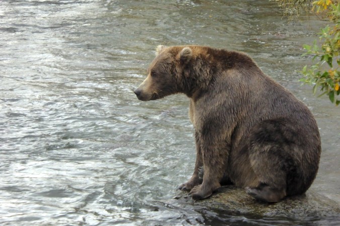
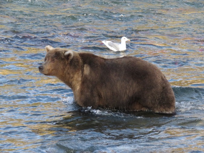
All brown bears, like this adult male known as 89 Backpack, get fat to survive.

Despite their lack of physical activity, hibernating bears maintain muscle strength and bone health. Even if immobilization didn’t cause starvation, osteoporosis, and atrophy in people, we would die of dehydration if placed in an equivalent situation. Hibernating bears, however, are nearly completely self-supporting. The only input they need from the outside world during hibernation is oxygen.

The physiology of bear hibernation is complicated and not fully understood. Scientists are still elucidating basic details about this remarkable process. For example, what causes bears to enter and exit the den? How long do bears need to switch their metabolism from to hibernating mode? As it turns out, the switch is a long process.

Researchers in Sweden used implanted heart rate monitors and GPS-enabled tracking collars on fourteen brown bears. The devices recorded the movement, heart rate, heart rate variability, and body temperature as well as ambient temperature and snow depth. The results, published last year in “Drivers of hibernation in the brown bear,” are insightful because it allowed the researchers to develop correlations between the variables that drive and trigger hibernation.

In fall, well before hibernation begins, body temperature and heart rate of bears began to decrease. Heart rate started to slow, on average, 24 days before den entry, and body temperature began to drop 13 days before den entry. Overall activity lessened 25 days before entry, but metabolic activity declined steeply just as the bears entered their dens. It took an additional 20 days after for heart rate and metabolic activity to bottom out.

The transition back to a more active physiology started long before bears left their dens. Heart and metabolic rate began to rise one month and 20 days, respectively, before den exit. Body temperature began to rise even earlier, a full two months before den exit when winter still locked the landscape in ice and snow. All bears left the den when their body temperature was 36.7˚C (98˚F) ± 0.15 °C, the active-state body temperature for brown bears. As the researchers note, the narrow temperature range at this time suggests bears exit the den when their body temperature reaches a specific point. Body temperature and metabolic rate stabilized 10 and 15 days, respectively, after den exit, but heart rate didn’t stabilize for another month.

Graph that shows the timing of several variables affecting the start and end of hibernation in bears.

These graphs chart the relationship between physiological parameters of brown bears in Sweden. Den entry (left column) and exit (right column) are indicated by time zero (the green vertical line) to determine the sequence of physiological events. SDANN is the standard deviation of heart rate variability over five minute intervals. It was used a proxy measure of metabolic activity. A red line denotes when a variable was decreasing, while a blue line indicates when a variable was increasing, with the number of days from the entry/exit indicated. From Drivers of Hibernation in the Brown Bear and reposted under the Creative Commons Attribution 4.0
International License.

Even though the bears’ physiology initiates the ultimate beginning and end of hibernation, climate plays a role in this process too. Changes to body temperature before den entry were affected by ambient air temperature, but bears largely relied upon a physiologic slowdown to cool themselves. In spring, bears left the den when the weather was right, exiting when air temperature rose to above 3.7˚C ± 1.5 ˚C (38.7˚F ± 2.7˚F).  Some biologists have suggested that food availability drives the timing of den entry, but this study did not attempt to test the hypothesis.

As a survival strategy, bear hibernation is remarkably efficient, and no other animal attains the same physiologic feats. Small mammal hibernators wake to pee; bears don’t even need to do that. Changing from an active metabolism to one of hibernation and back again takes a lot of time. If you are fortunate enough to see a bear in the middle of fall or the middle of spring, that bear is likely living in a transitional body equipped to handle two worlds—one with food and one without.


Filling the Gaps: 274

In the fall of 2016, a bear with a distinctive light-colored patch of fur on its left shoulder was seen at Brooks River. The identity of this bear, at the time, was a mystery. It behaved like it knew its way around the falls and looked like a bear I should recognize.

The problem was I didn’t. So, I speculated. Based on the bear’s shoulder patch, I said it could be 469, a bear who is not often seen at Brooks River but became of interest to webcam viewers in 2013 as he dealt with a leg or foot injury.

Afterwards, the mystery bear was sometimes labeled as 469 in photos and videos.

I was never sure of this ID. The bear’s face, overall fur color, and body size didn’t match 469, but my suggestion fueled further speculation when the bear returned in 2017.

I now know my identification was incorrect. Katmai’s staff has since identified this bear as 274.

bear standing in water with gull in background

Bear 274 Overflow on September 27, 2017. NPS photo.

274 is a maturing adult male and is believed to be the offspring of 438 Flo. Unlike most brown bear cubs, he and a sibling remained with their mother through four summers (most mother bears in Katmai keep their cubs for two to three summers). This is the only example of a brown bear family in Katmai remaining together for four summers.

bear family with older cubs sitting on grassy island

438 (center right) sits with her two 3.5 year-old offspring in 2010. One of these cubs, perhaps the bear on the far left, is believed to be 274.

I never had the opportunity to watch 274 in person in the fall as he is an infrequent visitor, which is perhaps the reason I was mistaken originally. Bears have distinctive features that allow us to identify them across seasons and years. Yet, they can be notoriously difficult to recognize from early summer to fall. 274’s wide-set blond ears and shoulder patch should remain distinctive identifying features during future autumns. His current shoulder patch, it should be noted, wasn’t present in 2012, the last time he was positively identified in the fall.

bear walking in water next to grassy bank

Bear 274 in September 2012. NPS photo.

As he continues to grow, we could see 274 attaining a higher rank in the bear hierarchy. During the last few years he’s not been timid when using Brooks Falls, but he’s also not been large enough to occupy the most preferred fishing spots without being displaced regularly. If genes (which control his potential for growth, health, and lifespan) and fortune (which provide the opportunity for him to attain his physical potential) align, then 274 could become one of the more dominant bears at Brooks River.

brown bear sitting and looking towards camera

Bear 274 in July 2016.

Filling the Gaps

Last July on bearcam, we witnessed the ascent of 32 Chunk in the hierarchy at Brooks Falls. Chunk was the largest bear to consistently use the falls in July, and most bears didn’t challenge him. We watched Chunk interact with many bears, occasionally with some that I (and many bearcam watchers) didn’t recognize. In mid July, for example, we saw Chunk displace another large adult male.

GIF of bear on left moving away from approaching bear who appears at right.

In this GIF from July 2017, a unidentified bear avoids the approach of 32 Chunk.

At the time, a few bearcam watchers speculated the subordinate bear may have been 856, who was the most dominant bear at Brooks River for many years. As I wrote in a previous post, I didn’t think this was 856. So who was it? Was he a previously identified bear or a newcomer to the river?

Before his seasonal position ended this fall, Ranger Dave from Katmai posted photos of several bears who were seen along the river, but were unknown or unrecognized by webcam viewers. Assuming Ranger Dave’s IDs are correct, which they are much more often than not, the unknown bear in the GIF above could be #611.

brown bear standing in water

Bear 611 at Brooks Falls in 2017. Photo courtesy of Dave Kopshever and Katmai National Park.

611 is a bear I don’t know much about. According to my notes, he was first identified in 2015, but only in September and October not in July. Preliminary bear monitoring data from that fall state this bear was an older subadult or young adult at the time.

611_09162015

611 in September 2015, the first year he was identified. NPS photo.

I may be splitting hairs or misunderstanding Dave’s intent, but note that Ranger Dave said, “This is believed to be 611” when he posted the photo. Perhaps there’s still some uncertainty regarding the ID. Filling in the gaps of who’s who at Brooks River can be difficult, and it isn’t possible to identify every bear with certainty. But—based on scars, size, head shape, and ear color—I am fairly convinced the bear in the 2017 photo posted by Ranger Dave is the same bear that Chunk displaced in the GIF above.

At Brooks River, I made the effort to learn to recognize the bears who used the river frequently. Since bear behavior is often complex and can vary from animal to animal, recognizing individual bears leads to a better understanding of their growth, behavior, and strategies for survival. If 611 returns in 2018, we’ll have another opportunity to observe his behavior. Will he challenge other adult males for fishing spots or will he avoid confrontation more often than not? Whatever happens, it will allow us to learn just a little more about the bear world.

Burpee Hill

Dry weather has been infrequent in western Washington this fall, so when a clear day dawned earlier this week I couldn’t resist the opportunity to take a wandering bike ride, one of my favorite pastimes. Over the last several years, my bicycle rides and hikes have become far more leisurely since I have become more prone to distraction. Without a fixed agenda though, I’m more open to discovery. Why, for example, would anyone pass on the chance to see a baby snake?

tiny snake in palm of gloved hand

This tiny garter snake was basking on the side of the road on a warm fall day in late October. Concerned it might become road kill, I moved it off of the pavement.

With temperatures near freezing on Monday, I wasn’t going to find any snakes, but over a fifty mile round trip—from Skagit River to the end of the road near Baker Lake—I found more than enough to hold my attention. After a mere two miles of pedaling, I found a reason to pause.

I began at the old concrete silos in Concrete, a small town along the middle reaches of Skagit River…

Concrete silos. Text on silos reads,

Why was Concrete named Concrete? You only get one guess.

Cycling route profile from Google Maps.

No, I didn’t ride the hill as slowly as Google Maps says it will take.

…and immediately began a steep climb up Burpee Hill. In two miles, the road gains over 800 feet of elevation, although I didn’t mind the opportunity to warm up with frost lingering on the grass.

The North Cascades region is the sum of a complex geologic history. Large-scale mountain building, volcanism, and extensive glaciation created and shaped a landscape of unparalleled ruggedness in the Lower 48 states. This area’s geology is, well, complicated. Just take a look at the geologic map.

screen shot of geologic map of Mount Baker and Baker Lake area

Yikes.

On a bicycle, unlike in a car, stopping to check out roadside curiosities—wildlife, road kill, trees, wildflowers, rocks, scenery—is very easy and is an important reason why I enjoy it so much. About half way up the Burpee Hill climb, I stopped to ponder some interesting sediments exposed in a road cut. The coarse to fine grained sediments were well sorted, indicating flowing water had deposited them, and were capped by a mix of unsorted rocks. This is one piece of a grander glacial puzzle.

view of road cut

A few exposures of loose and coarse sediment can be found on the Burpee Hill Road.

Maps that outline the last glacial maximum in North America give the impression that ice flowed largely north to south. While generally true, the story is a bit more complex on a local scale, as Burpee Hill illustrates.

Glaciers are masses of ice that flow and deform, and they behave differently than ice from your freezer. Set an ice cube on a table and strike it with a hammer and it will fracture. Ice in a glacier’s interior, however, is under tremendous pressure. Ice crystals are altered and deformed like plastic putty, so much so that only the upper 30 meters of temperate glaciers are brittle. (The relatively consistent maximum depth of crevasses reveals this fact. Below 30 meters, deforming ice seals any crevasses. Cavities at the base of glaciers have been measured to seal as fast as 25 centimeters per day.) The ice is not impervious to liquid water though. Within temperate glaciers, ice remains at or slightly above freezing, which allows meltwater to percolate to the glacier’s base. Pressure from overlying ice also causes some water to melt at the bed. Once there, meltwater acts as a lubricant helping the glacier slide. These factors, combined with gravity’s pull, drive glaciers along the paths of least resistance, and sometimes these paths lead uphill.

Between 19,000 and 18,000 years ago, a broad lobe of the cordilleran ice sheet invaded the lowlands of Puget Sound. Fingers of the ice sheet reached into the North Cascades as it continued to advance southward. Around 16,000 years ago, the ice sheet reached its maximum extent in western Washington, reaching south beyond Seattle, Tacoma, and Olympia.

On the margin of the ice sheet, lowland valleys like the Skagit offered ice easy passage as it advanced. About 18,000 years ago in the lower and middle reaches of the Skagit valley, ice flowed in the opposite direction of the modern Skagit River. Burpee Hill is largely the result of this process. It’s a 200 meter-thick layer of glacial outwash, glacial lake sediments, and glacial till deposited at the front of ice as it advanced up the Skagit valley. The features are clearer in a LIDAR image.

LIDAR Image

Burpee Hill is the wedge-shaped feature in the center of the image.

LIDAR image with labels. From left to right:

Glacial ice from the Puget Sound area flowed east over the current location of Concrete. The sediments that make Burpee Hill were deposited in front of the advancing ice.

Since its formation, erosion and landslides have eaten away at Burpee Hill, and it is easy to overlook when the lure of craggy peaks and snow-capped volcanoes always dangles ahead. If volcanoes and orogenies are architects of this landscape, then glaciers are certainly its sculptor, reshaping landforms in profound ways. Stories like this are tucked away everywhere. Landforms are rarely ordinary.

Epilogue:
I continued my ride, which (in case you’re wondering) was wonderful even though temperatures remained near freezing. As I expected it to be on week day in early December, the road was quiet. The views of Mount Baker, pockets of old growth forest, and Baker Lake were worth the effort.
view of snow capped volcano and creek valley